Tours
Activities
Places of interest
Where to eat
Where to sleep

Discover the treasures of Fougerolles, Haute-Saône, Franche-Comté

Are you in charge of the destination?
Fougerolles, nestled in Haute-Saône within the picturesque region of Franche-Comté, is a destination full of charm and discovery. Known for its renowned kirsch, this town invites you to explore a rich heritage and breathtaking landscapes.

Embark on a journey through the extensive cherry orchards surrounding the village, a captivating sight especially in spring. The Fougerolles Distillery opens it...
See more

Walking around Fougerolles

See more suggestions
Explore the walking circuits of Fougerolles.
See more suggestions
Randonnée - la vallée d'hamanxard et rapaumont
7.3 km

Randonnée - la vallée d'hamanxard et rapaumont

Access: From Remiremont go to Val-d'Ajol, go to the church. Parking: Park at Place du Sô. Distance: 11 km / Duration: 3 h 30 / Difference in height: 390m / Marking: Green disc. 1) From the church, follow the road to Saint-Bresson (former Gerbe d'Or brewery). Take the forest path and then a tarmac track leading off to the left to an inhabited clearing. Go around the dwellings by a forest track to the top of the mountain (old quarries on the left on the summit used to build the church). Follow the ridge path through the large Scots pines without leaving the forest. 2) At the junction with a tarmac path, head towards the farm on the left (fountain). At the first bend, a path on the left descends through a beech forest. Through a succession of small paths, reach the bottom of the Hamanxard valley (old workers' housing estate, school, farms). 3) The D20 at the bottom of the valley offers a shortcut in case of fatigue or unforeseen circumstances. If you choose to continue, cross the hamlet of Leyval straight ahead (several calvaries). A new ascent begins on a dirt track after a succession of fountains. 4) When you reach the hamlet of Les Granges de Leyval, turn sharply left after the last building. Continue along a grassy path in the direction of the television relay station on the other side (panoramic view of Faymont, Les Feuillées and the Val-d'Ajol). 5) Go down on a small road towards the village of Val-d'Ajol, which you can soon see. 6) Go down through the pastures on a grassy path. After crossing a wetland area often covered with periwinkle, take the path on the right. 7) At the hamlet of La Rochotte (17th century cross and viewpoint), follow the right-hand track which runs down the rest of the hill and leads back to the village by the road.

4 h
11 km
Medium
1 Place de l'église 88340 LE VAL D AJOL
Show
Randonnée - circuit découverte des croix
7.3 km

Randonnée - circuit découverte des croix

Access: From Remiremont, go to Val-d'ajol. Parking: opposite the Peugeot garage, route de Plombières. Distance: 7.5 km / Duration: 2 h 30 / Difference in height: 100m / Signs: green ring. 1) Leave the car park in the direction of the church. Turn right before the bridge and walk along the river to the next bridge. Cross the De Buyer bridge and head towards the Post Office (1719 cross on the right of the Post Office). Go back in the direction of the church. Go back to the small square in rue de Plombières (border marker). Continue to the small square at the foot of the church, opposite the bakery (a 17th century cross). Go up the main street for 200m, passing the war memorial. 2) In the middle of a small square, go towards the Gravel cross (named after a former tabellion general). Continue along the main road to the next crossroads. Follow the Rue du Prieuré d'Hérival which leads to the old station. Walk along the square on the right. At the next crossroads, turn left onto the D20 in the direction of Hamanxard or rue des Mousses. Along the wall of the hotel, a path leads to a place of meditation (imitation of the grotto at Lourdes). 3) Continue along rue des Mousses (D20). On the pavement on the right are three old calvaries (two from the 17th century, one from 1803). Then branch off onto the route de Rapaumont (the Jean Sauvé cross at the crossroads). 4) At the bottom of the hill after a small bridge, a 500m loop leads to the hamlet of La Rochotte (1636 cross and panoramic view of the Val-d'Ajol). Back at the bottom of the hill, walk along the meadow to the hamlet of Bouchâtel. Take the D23 on the right. 5) Stop at Les Chênes (three crosses to visit). After this small hamlet, follow the small road of La Banvoie to the left. 6) At the hamlet called le Pied du Mont (one cross) turn left. 7) At La Banvoie, go back 100m to the right (2 crosses). 8) At the Mésaubé (a cross on the left), go back 30m then head towards the Granges (a cross) and the Cross (a small calvary from 1601). 9) Turn right towards Le Moncel. 10) In the hamlet of Moncel (an old cross at the crossroads), go back 100m to the right (second cross) and return to the starting point by the left-hand street.

3 h
7.5 km
Easy
117 17 route de Plombières Départ depuis l'ancien Office de Tourisme 88340 LE VAL D AJOL
Show
Randonnée - la forêt du chanot
8 km

Randonnée - la forêt du chanot

Access: From Remiremont, take the expressway towards Vesoul. Take the D20 exit for Le Val-d'Ajol, then head for La Croisette at the roundabouts. Parking: park at "l'Hôtel Enfoncé". Distance: 6 km / Duration: 2 h / Difference in height: 130m / Signs: yellow ring. 1) Start from the place called l'Hôtel Enfoncé. Follow the large forest path opposite the Foyer Rural. 200 m after the refuge chalet, take the left-hand path. Go straight on until you reach the magnificent viewpoint of La Feuillée Nouvelle, which is located after the television relay station. 2) On the right at the end of the terrace, a gravel path leads down to the D20. Follow this road for 100 m downstream, until the first bend in the road, where you take a forest track to the right. Follow it for about 1 km until it joins another forestry lane called the Grande Tranchée. 3) Immediately turn left onto a dirt track that runs along the ridge. A hook on the left offered a viewpoint that no longer exists. Therefore, stay on the same ridge path. 4) Leave the ridge path on the right. Cross the Grande Tranchée again. Follow the edge of the forest to the first path on the left leading out of the wood. Cross a tarmac track and take the first path on the right towards the Etang des Prêtres (this pond was listed in the inventory of the Priory of Hérival in 1792). 5) Go along the pond, bypassing it from the north and taking a wide path lined with new houses, then at the next crossroads go back into the forest on a grassy path. 6) Once on the D20, turn right towards the summit to reach the car park after 200 m.

2 h
6 km
Easy
lieu-dit "Hôtel Enfoncé" 88340 LE VAL D AJOL
Show
Randonnée - le chemins des pierres
8.9 km

Randonnée - le chemins des pierres

Access: From Remiremont, go to Plombières-les-Bains. Cross the town then take the Casino direction. Parking: Park opposite the Parc Impérial. Distance: 9 km / Duration: 3 h / Difference in height: 170m / Marking: green disc. 1) Leave the Parc Impérial and walk around the outdoor swimming pool to the left. Cross the old railway bridge over the Augronne. Walk about 500m on the old ballast. 2) Leave the ballast for a tarmac path, then a second path, only gravelled, going to the right. In its first part, it follows the contour line. As the path widens and rises, keep the same course. 3) A sign indicates the Pierre Rousseau situated slightly below the path (text engraved in the stone borrowed from Rousseau). Continue straight on to the Moulin Taqueré (remains of the last mill near the stream). stream). 4) Retrace your steps to the farm, walk along the edge of the forest in search of the Red Cross (on the base: the names of the three young men who were massacred in this forest). At the next crossroads, a short signposted track leads to the cup stone, 300m round trip. Continue upstream on a wide forest track leading to the hamlet of Petit Moulin. 5) Cross this hamlet then the D 157 and go straight into the small wood. At the end of the wood, a tarmac track leads from farm to farm. At the second crossroads, turn left towards the gas station. 6) Meet the fountain circuit. Follow the left-hand path towards a last farm and its calvary. Go down to the forest and follow the small path on the right. 7) The end of the circuit, all downhill, leads back to the imperial park by the main street of the station or by the discovery circuit of Plombières and the Tivoli park.

3 h
9 km
Medium
1 Allée Eugene Delacroix Au abords du Parc Impérial 88370 PLOMBIERES LES BAINS
Show

What to do in Fougerolles

See more suggestions
Explore Fougerolles through its many bookable activities.
See more suggestions
Comprehensive Strasbourg rickshaw tour - 1 hr 20 mins
126 km

Comprehensive Strasbourg rickshaw tour - 1 hr 20 mins

Enjoy this guided rickshaw tour to discover all of Strasbourg! Your driver and tour guide will let you in on the city's secrets! Rickshaws are a unique way to get around and see all the key sites of Strasbourg in just 1 hour and 20 minutes! Your driver will do the pedalling while you enjoy the city's key sites. Once you are comfortably seated on your rickshaw, you will start your tour by discovering the Palais Rohan. This magnificent monument with a classical façade has been classified as a historic monument. In 2009, it opened its doors to the most powerful world leaders on a NATO summit. You will then be taken to the Place Broglie to marvel at Strasbourg's stunning opera house. You will be captivated by its neoclassical façade, which has been classified as a historic monument! Your visit will continue with the Place de la République, where you will admire the relics of German architecture. This stunning square is home to the German imperial district's most iconic monuments. You will then enter into the heart of the German neighbourhood to discover its Haussmann-style avenues, the European sites and the Orangerie district. You will also get a glimpse at the headquarters of the French-German cultural TV channel: Arte.   Your tour will end by a ride through the "Petite-France" neighbourhood, at the heart of the old town. Marvel at typical half-timbering houses built right above the water. You will enjoy an exceptional scenic view on the terrace of the Barrage de Vauban. Let this quaint neighbourhood - which is a UNESCO World Heritage Site - captivate you! Pick this tour and visit all the key places of Strasbourg in an unusual and pleasant way!

Book from 90 EURBook
Show

IGN cards

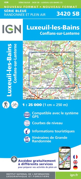
3420SB - LUXEUIL-LES-BAINS CONFLANS-SUR-LANTERNE
Editor : IGN
Collection : TOP 25 ET SÉRIE BLEUE
Scale : 1:25 000
13.90€
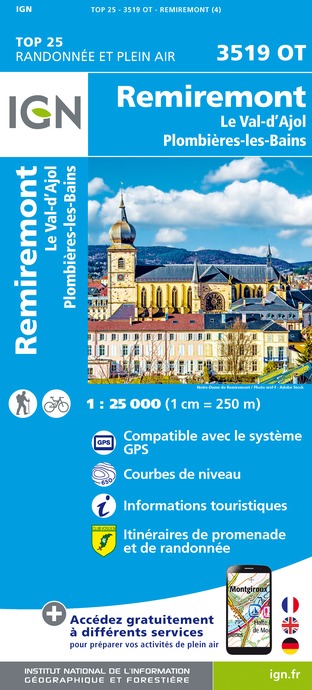
3519OT - REMIREMONT LE VAL-D'AJOL PLOMBIÈRES-LES-BAINS
Editor : IGN
Collection : TOP 25 ET SÉRIE BLEUE
Scale : 1:25 000
13.90€
TOP100D68 - HAUT-RHIN TERRITOIRE DE BELFORT COLMAR MULHOUSE BELFORT PNR DES BALLONS DES VOSGES
Editor : IGN
Collection : TOP 100
Scale : 1:100 000
8.40€
130 VESOUL LANGRES VALLÉE DE LA SAÔNE
Editor : IGN
Collection : TOP 100
Scale : 1:100 000
8.40€
TOP100D88 - VOSGES ÉPINAL NEUFCHÂTEAU ST-DIÉ-DES-VOSGES GÉRARDMER PNR DES BALLONS DES VOSGES
Editor : IGN
Collection : TOP 100
Scale : 1:100 000
8.40€
TOP100D70 - HAUTE-SAÔNE VESOUL LURE VALLÉE DE LA SAÔNE
Editor : IGN
Collection : TOP 100
Scale : 1:100 000
8.40€
201 ALSACE MASSIF DES VOSGES
Editor : IGN
Collection : TOP 200
Scale : 1:200 000
6.80€
89026 - GRANDES TRAVERSÉES DU JURA - GTJ
Editor : IGN
Collection : DECOUVERTE DES CHEMINS
Scale : 1:105 000
9.10€
D70-88-90 HAUTE-SAÔNE VOSGES TERRITOIRE DE BELFORT
Editor : IGN
Collection : CARTES DÉPARTEMENTALES IGN
Scale : 1:150 000
5.90€
D67-68 BAS-RHIN HAUT-RHIN
Editor : IGN
Collection : CARTES DÉPARTEMENTALES IGN
Scale : 1:150 000
5.90€
NR09 BOURGOGNE FRANCHE-COMTÉ
Editor : IGN
Collection : CARTES RÉGIONALES IGN
Scale : 1:250 000
6.80€
SUISSE
Editor : IGN
Collection : DÉCOUVERTE DES PAYS DU MONDE IGN
Scale : 1:303 000
7.00€
ALLEMAGNE
Editor : IGN
Collection : DÉCOUVERTE DES PAYS DU MONDE IGN
Scale : 1:800 000
7.00€
EUROPE
Editor : IGN
Collection : DÉCOUVERTE DES PAYS DU MONDE IGN
Scale : 1:2 500 000
7.00€

What to visit in Fougerolles

See more suggestions
Experience the annual festivals of Fougerolles.
See more suggestions

Where to eat in Fougerolles

See more suggestions
The dining spots in Fougerolles have surprises in store.
See more suggestions

Where to sleep in Fougerolles

See more suggestions
Explore hostels and hotels in Fougerolles.
See more suggestions
Caution!
We have no information on the difficulty of this circuit. You may encounter some surprises along the way. Before you go, please feel free to inquire more and take all necessary precautions. Have a good trip! 🌳🥾