Tours
Activities
Places of interest
Where to eat
Where to sleep
Camping de La Bonde in La motte-d'aigues: Nature and Discovery
Are you the owner?Welcome to Camping de La Bonde in La motte-d'aigues, Vaucluse! Uncover the numerous activities and attractions this beautiful region in Provence-Alpes-Côte d'Azur has to offer. Begin your adventure at the majestic Lac de La Bonde, perfect for swimming, fishing, or simply relaxing by the water.
Hiking enthusiasts will be delighted with the many marked trails, such as those of the Luberon Massif, o...See more
Hiking enthusiasts will be delighted with the many marked trails, such as those of the Luberon Massif, o...See more
Walking around CAMPING DE LA BONDE
See more suggestionsExplore the hiking trails around CAMPING DE LA BONDE.
See more suggestions


")

")


What to do in CAMPING DE LA BONDE
See more suggestionsFind bookable activities in CAMPING DE LA BONDE for an unforgettable experience.
See more suggestions


IGN cards
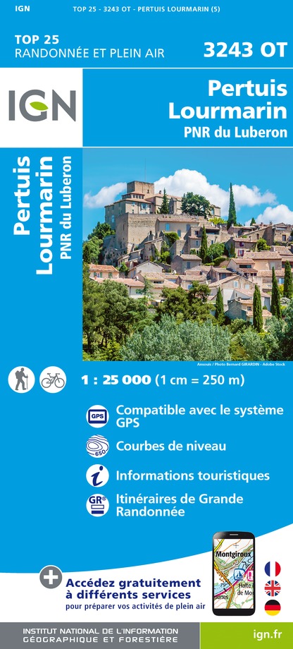
3243OT - PERTUIS LOURMARIN PNR DU LUBERON
Editor : IGN
Collection : TOP 25 ET SÉRIE BLEUE
Scale : 1:25 000
13.90€

TOP75034 - LUBERON MONT VENTOUX
Editor : IGN
Collection : TOP 75
Scale : 1:75 000
9.80€

VEL03 - LE VAUCLUSE A VÉLO
Editor : IGN
Collection : DECOUVERTE A VELO
Scale : 1:100 000
9.10€

TOP100D13 - BOUCHES-DU-RHÔNE MARSEILLE AIX-EN-PROVENCE PARC NATIONAL DES CALANQUES PNR DES ALPILLES ET DE CAMARGUE
Editor : IGN
Collection : TOP 100
Scale : 1:100 000
8.40€

TOP100D04 - ALPES-DE-HAUTE-PROVENCE DIGNE MANOSQUE PNR DU VERDON LAC DE SERRE-PONÇON
Editor : IGN
Collection : TOP 100
Scale : 1:100 000
8.40€

TOP100D84 - VAUCLUSE AVIGNON CARPENTRAS PARCS NATURELS RÉGIONAUX DU LUBERON ET DU MONT-VENTOUX
Editor : IGN
Collection : TOP 100
Scale : 1:100 000
8.40€

TOP100D83 - VAR TOULON FRÉJUS MASSIFS DES MAURES ET DE L'ESTEREL PARC NATUREL RÉGIONAL DU VERDON
Editor : IGN
Collection : TOP 100
Scale : 1:100 000
8.40€

D83 VAR
Editor : IGN
Collection : CARTES DÉPARTEMENTALES IGN
Scale : 1:150 000
5.90€

D04-05 ALPES-DE-HAUTE-PROVENCE HAUTES-ALPES
Editor : IGN
Collection : CARTES DÉPARTEMENTALES IGN
Scale : 1:150 000
5.90€

D13-84 BOUCHES-DU-RHÔNE VAUCLUSE
Editor : IGN
Collection : CARTES DÉPARTEMENTALES IGN
Scale : 1:150 000
5.90€

NR16 PROVENCE-ALPES-CÔTE D'AZUR
Editor : IGN
Collection : CARTES RÉGIONALES IGN
Scale : 1:250 000
6.80€

EUROPE
Editor : IGN
Collection : DÉCOUVERTE DES PAYS DU MONDE IGN
Scale : 1:2 500 000
7.00€
What to visit in CAMPING DE LA BONDE
See more suggestionsExplore the cultural heritage of CAMPING DE LA BONDE.
See more suggestions


Where to eat in CAMPING DE LA BONDE
See more suggestionsDiscover the culinary diversity of CAMPING DE LA BONDE.
See more suggestions


Where to sleep in CAMPING DE LA BONDE
See more suggestionsDiscover popular accommodations in CAMPING DE LA BONDE.
See more suggestions


