Tours
Activities
Places of interest
Where to eat
Where to sleep
Camping Le Moulin à Vent: Discover Cucuron and Surroundings
Are you the owner?Welcome to the CAMPING LE MOULIN A VENT page! Located in Cucuron, Vaucluse, in the heart of Provence-Alpes-Côte d'Azur, our campsite is the perfect starting point for exploring the region's treasures. Start with a stroll around the iconic Cucuron pond, surrounded by ancient plane trees and charming cafés where you can sip a coffee while admiring the landscape. Just a few kilometers away, nature an...See more
Walking around CAMPING LE MOULIN A VENT
See more suggestionsDiscover the walking paths of CAMPING LE MOULIN A VENT.
See more suggestions


")

What to do in CAMPING LE MOULIN A VENT
See more suggestionsEnjoy unforgettable moments in CAMPING LE MOULIN A VENT by booking activities for everyone.
See more suggestions


IGN cards
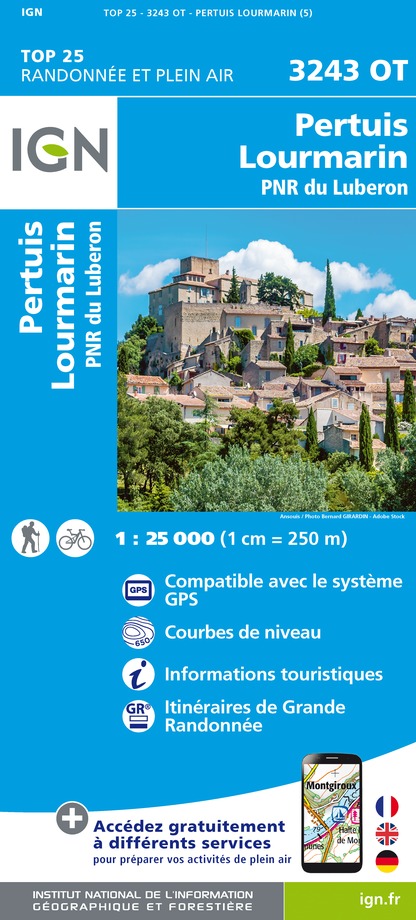
3243OT - PERTUIS LOURMARIN PNR DU LUBERON
Editor : IGN
Collection : TOP 25 ET SÉRIE BLEUE
Scale : 1:25 000
13.90€

TOP75034 - LUBERON MONT VENTOUX
Editor : IGN
Collection : TOP 75
Scale : 1:75 000
9.80€

VEL03 - LE VAUCLUSE A VÉLO
Editor : IGN
Collection : DECOUVERTE A VELO
Scale : 1:100 000
9.10€

TOP100D13 - BOUCHES-DU-RHÔNE MARSEILLE AIX-EN-PROVENCE PARC NATIONAL DES CALANQUES PNR DES ALPILLES ET DE CAMARGUE
Editor : IGN
Collection : TOP 100
Scale : 1:100 000
8.40€

TOP100D84 - VAUCLUSE AVIGNON CARPENTRAS PARCS NATURELS RÉGIONAUX DU LUBERON ET DU MONT-VENTOUX
Editor : IGN
Collection : TOP 100
Scale : 1:100 000
8.40€

D04-05 ALPES-DE-HAUTE-PROVENCE HAUTES-ALPES
Editor : IGN
Collection : CARTES DÉPARTEMENTALES IGN
Scale : 1:150 000
5.90€

D13-84 BOUCHES-DU-RHÔNE VAUCLUSE
Editor : IGN
Collection : CARTES DÉPARTEMENTALES IGN
Scale : 1:150 000
5.90€

D83 VAR
Editor : IGN
Collection : CARTES DÉPARTEMENTALES IGN
Scale : 1:150 000
5.90€

NR16 PROVENCE-ALPES-CÔTE D'AZUR
Editor : IGN
Collection : CARTES RÉGIONALES IGN
Scale : 1:250 000
6.80€

EUROPE
Editor : IGN
Collection : DÉCOUVERTE DES PAYS DU MONDE IGN
Scale : 1:2 500 000
7.00€
What to visit in CAMPING LE MOULIN A VENT
See more suggestionsEnjoy the green spaces of CAMPING LE MOULIN A VENT.
See more suggestions


Where to eat in CAMPING LE MOULIN A VENT
See more suggestionsThe restaurants of CAMPING LE MOULIN A VENT await you.
See more suggestions


Where to sleep in CAMPING LE MOULIN A VENT
See more suggestionsBook a quality accommodation in CAMPING LE MOULIN A VENT.
See more suggestions


