Tours
Activities
Places of interest
Where to eat
Where to sleep
Discover Aragon, Aude, Languedoc-Roussillon
Are you in charge of the destination?Situated in the heart of Aude, amidst rolling countryside and lush vineyards, Aragon, in the Languedoc-Roussillon region, is the ideal destination for lovers of culture and nature. Begin your exploration in the charming medieval village of Aragon itself, where narrow lanes and stone houses will transport you back in time. Don't miss the St. Valentine Church, an architectural gem from the 12th cent...See more


What to do in Aragon
See more suggestionsBook your activities in Aragon now and get ready for adventure.
See more suggestions


IGN cards
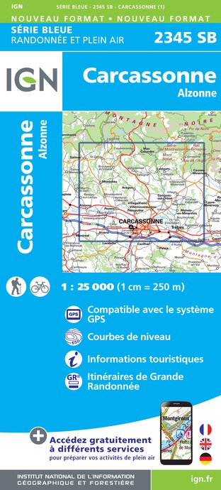
2345SB - CARCASSONNE ALZONNE
Editor : IGN
Collection : TOP 25 ET SÉRIE BLEUE
Scale : 1:25 000
13.90€

TOP100D11 - AUDE CARCASSONNE NARBONNE LIMOUX QUILLAN CANAL DU MIDI
Editor : IGN
Collection : TOP 100
Scale : 1:100 000
8.40€

TOP100D09 - ARIÈGE FOIX SAINT-GIRONS PNR DES PYRÉNÉES ARIÉGEOISES
Editor : IGN
Collection : TOP 100
Scale : 1:100 000
8.40€

89031 - LE CANAL DU MIDI
Editor : IGN
Collection : DECOUVERTE DES CHEMINS
Scale : 1:100 000
9.10€

D09-66 ARIÈGE PYRÉNÉES-ORIENTALES
Editor : IGN
Collection : CARTES DÉPARTEMENTALES IGN
Scale : 1:150 000
5.90€

D11-81 AUDE TARN
Editor : IGN
Collection : CARTES DÉPARTEMENTALES IGN
Scale : 1:150 000
5.90€

EUROPE
Editor : IGN
Collection : DÉCOUVERTE DES PAYS DU MONDE IGN
Scale : 1:2 500 000
7.00€


Where to sleep in Aragon
See more suggestionsBook your stay at one of Aragon's accommodations.
See more suggestions


")


