Alert
Alerts
Tour of the Aiguille de la Vanoise - Stage 1 - Fontanettes car park - Col de la Vanoise refuge

IGN cards


Description
A beautiful 2-day itinerary between glaciers and mountain lakes. Imagine jumping from rock to rock to cross Lac des Vaches in the majestic setting of the most beautiful peaks in the Vanoise.
You'll set off on a varied route between forest and high mountain.
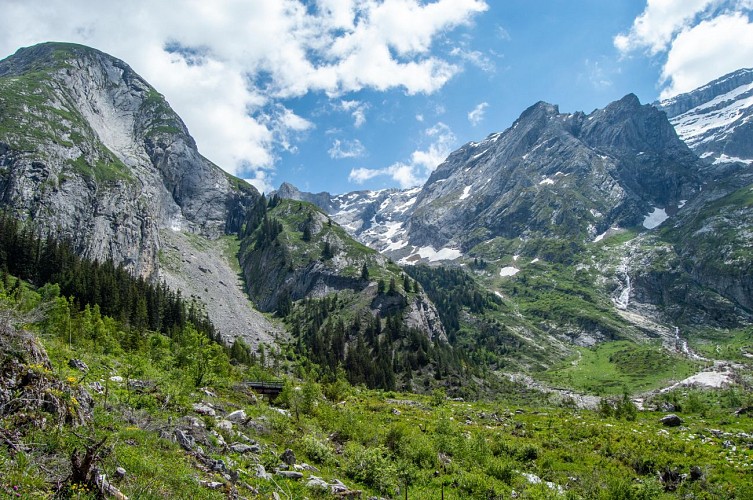
It's an easy start from the Fontanettes car park, and you'll soon take a small forest path that will lead you to the enchanted forest of the Bois de la Glière... This path winds its way between large moss-covered boulders, inviting you to look up at the treetops, walk through the fir cones or touch the bark of the trees.... Suddenly the forest comes to a halt and you come to a platform that invites you to look up at the summit of Pointe du Dard, from where avalanches can sometimes be quite impressive!
The path continues into the cirque de l'Arcelin, a natural amphitheatre offering a breathtaking view of the great vertical walls of Moriond, the Aiguilles de l'Arcelin and the Grand Marchet.
Then take the path known as "Les Arollets" to the right of Moriond. You will then quickly ascend, along a sometimes technical path, towards the Lac des Assiettes plateau and then the Col de la Vanoise refuge.
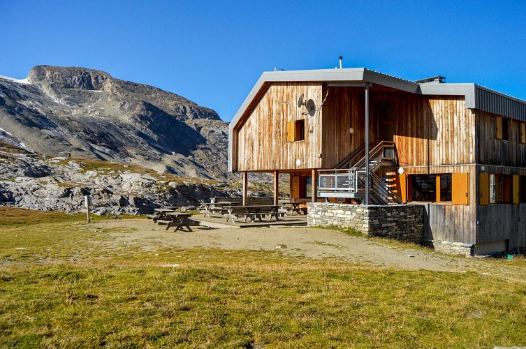
The refuge offers a unique view of the Grande Casse and its glacier, the Arête de la Réchasse, the Grande and Petite Glière... Here you can enjoy a good night's rest after tasting the keeper's delicious dishes.
Technical Information
Altimetric profile
Starting point
Points of interest


Additional information
Open period
From 01/06 to 21/09.
This route is accessible outside the snow season and subject to favourable weather conditions. It is advisable to book huts in advance. Refuges manned at this time of year.
Updated by
Office de Tourisme de Pralognan-la-Vanoise - 18/08/2025
www.pralognan.com/
Report a problem
Environments
Lakeside or by stretch of water
Riverside
Close to GR footpath
Mountain view
Waterside
Lake view
Mountain location
In a nature reserve
Presence of livestock and guard dogs
Close to a public transportation
Near shuttle stop
Contact
Phone : 04 79 08 79 08
Email : info@pralognan.com
Website : https://www.pralognan.com/
Facebook : https://www.facebook.com/pralognan/
Type of land
Stone
Ground
Not suitable for strollers
Location complements
From Albertville, take the RN90 to Moûtiers, then follow signs for Bozel, then Pralognan-la-Vanoise.
Before entering the village, turn left towards the Fontanettes car park.
There is a free shuttle bus from the village centre to the car park in July and August.
Topo guides and map references
Topo guides references :
Downloadable from:www.pralognan.com/
Map references :
TOP 25 IGN 3534OT Les 3 Vallées
Reception complements
Drinking water points in the Fontanettes car park, at the Col de la Vanoise and Les Barmettes huts.
Rules in the heart of the Vanoise National Park:
- Do not bring dogs, even on a lead
- Do not pick or take any flowers, fruit, insects or minerals
- Take away all your rubbish
- Do not disturb the tranquillity of the area or the wildlife by noise, shouting or sound equipment
- Do not camp or bivouac EXCEPT near certain refuges
- Do not light fires
- Stay on the paths and avoid cutting the paths when descending
- Do not practice paragliding or other aerial sports
- Do not mountain bike
- Do not use motorised vehicles
Guidebook with maps/step-by-step
1/ DAY 1: From the Fontanettes car park to the Col de la Vanoise refuge. Duration: 3h / Ascent: +858m / Descent : -5m / From the Fontanettes car park, take the 4x4 path to the right of the Genépi chairlift / After a few minutes' walk, take the path to the left, which leads into the Glières forest (the playful “lutin” path), as far as the Arcelin cirque / Then take the path known as “les Arollets”, to the right of Moriond, which will take you to the Col de la Vanoise hut (red path).
Animals
No
