To see around
See more
Open
Close
Show
Show
Show
Show
Show
Show
Show
Show
Show
Show
Show

Oups... It would appear that Cirkwi does not have permission to use your location.

Description
Map
Steps
Points of interest
Cirkwi brief's
Ratings and reviews
See around

Emerald Circuit

Emerald Circuit

Description

The Fusain, a tributary of the Loing, is located so well at the foot of Château-Landon that it splits into several branches to occupy the valley floor.
Valley bottom that this circuit allows to discover, level then in height.

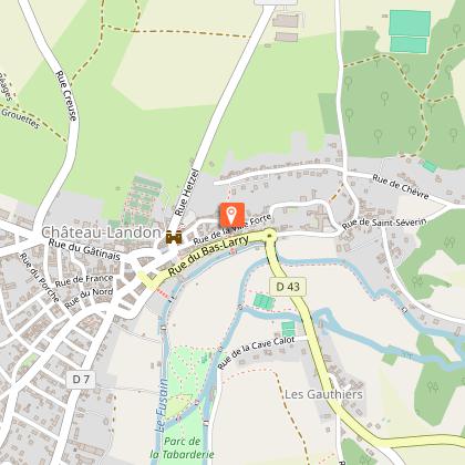
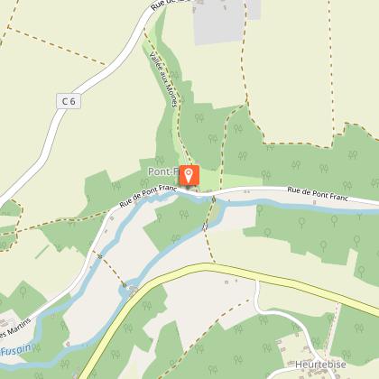
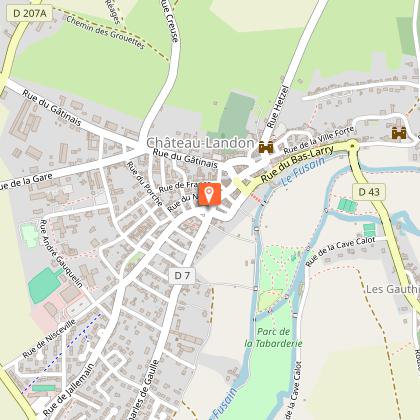
With your back to the Tourist Office, go left then turn left into rue de la Ville Forte. Go down the stairs to the right by the South Poterne. It crosses the rue du Bas Larry, and runs down to the bridge over the charcoal. Cross it and turn right, path of the lovers, along the river. After the communal washhouse, turn left twice and walk along the other arm of the Fusain. Cross the bridge, continue on the other side. Cut the road, take the path opposite and continue along the river. Take the bridge on the left, follow for 1200m, rue des Martins on the right followed by rue de Pont Franc. Passed Pont Franc, turn right into the path, cross the 2 arms of the Fusain and, straight ahead, join the "Moulin de Bigonnneau". Go along the D43 on the left then turn into the road on the right. Go up the path on the left (GR 13) to arrive at the hamlet of Fusselette. Turn right, walk alongside the Touvent farm, cross the D 52 and follow the path that turns right. Turn right into the path then into the road and left into the grassy path (viewpoint on the ramparts).
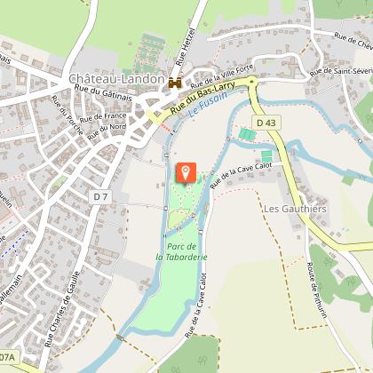
At the Tabarderie, follow the road to the left, turn right twice to cross 2 arms of the Fusain. Continue crossing the park towards the city, to the right of the 3rd arm of the Fusain. Cross the Caesar bridge and follow the Fusain to the right. Climb the stairs, cross the rue du Bas Larry to enter the lane of the Hospice Turn right rue Jean Galland and arrive at the Place du Marché and the Tourist Office.
This route is marked in green by the Codérando.

Technical informations

This circuit was updated on: 25/02/2024
7.4 km
2 h 30 mn
max. 104 m
min. 69 m
97 m

Altimetric profile

Starting point

4 6 rue Hetzel , 77570 Château-Landon
Lat : 48.149892Lng : 2.703541

Steps

image du object
1

Départ

Partez de l'Office de Tourisme, rue Hetzel, prenez à gauche la rue de la Ville Forte. Descendez les marches à droite, la Poterne Sud. Traversez la rue du Bas-Larry et empruntez les escaliers en face. Passez le pont et tournez à droite sur le Chemin des Amoureux. Vous êtes dans le Parc de la Tabarderie.

6 rue Hetzel 77570 Chateau-landon
- Office de Tourisme Gatinais Val de Loing -
Consulter
image du object
2

Étape 2

Après le Grand Lavoir, tournez à gauche puis reprendre à gauche en longeant la rivière "le Fusain". Toujours suivre à gauche jusqu'à la route des Gauthiers (coup d’œil à 50 mètres à gauche : le Moulin de Beaupoivre.

Sentier des Amoureux 77570 Chateau-landon
- Office de Tourisme Gatinais Val de Loing -
Consulter
image du object
3

Étape 3

Traversez la route, longez le Fusain et au pont à gauche, le traverser pour atteindre la route de Pont Franc (rue des Martins).

6146 Les Gauthiers 77570 Chateau-landon
- Office de Tourisme Gatinais Val de Loing -
Consulter
image du object
4

Étape 4

Prenez à droite, marchez pendant 1,5 km jusqu'à Pont Franc. Traversez un pont à droite jusqu'à la route de Néronville (D43). Prenez à gauche sur 100 mètres, tournez à droite et prenez le chemin GR13 sur la droite.

7 Rue des Martins 77570 Chateau-landon
- Office de Tourisme Gatinais Val de Loing -
Consulter
image du object
5

Étape 5

Arrivé à Fusselette, prenez à droite, le long des maisons puis longez les bois. A Touvent traversez tout droit la route de Nargis la D52 et suivre le chemin. A la 2ème intersection obliquez à droite le long du Parc.

Rue Fusselette 77570 Chateau-landon
- Office de Tourisme Gatinais Val de Loing -
Consulter
image du object
6

Étape 6

Arrivé à la route de Pithurin tournez à droite la prendre sur environ 200 mètres et prenez le chemin à gauche puis 200 mètres après tournez à droite. (Coup d’œil sur les remparts). Descendez le chemin jusqu'à la route de la Cave Calot, la prendre à gauche sur 150 mètres et traversez le Fusain à droite par le pont, allez tout droit dans le Parc de la Tabarderie pour atteindre le pont de César dit Brunel.

6 Route de Pithurin 77570 Chateau-landon
- Office de Tourisme Gatinais Val de Loing -
Consulter
image du object
7

Étape 7

Le traverser et aussitôt à droite longez le Fusain jusqu'à l'escalier qui monte à la rue du Bas-Larry (vue sur l'arrière de l'Hôtel-Dieu). Prenez en face la ruelle de l'Hospice puis à droite la rue Jean Galland pour arriver place du Marché et à l'Office de Tourisme.

3 Rue de la Tabarderie 77570 Chateau-landon
- Office de Tourisme Gatinais Val de Loing -
Consulter

Points of interest

image du object

The Saint-Thugal Tower

Installed on the city's defenses next to the South Poterne which is an open passage in the ramparts leading to the Charcoal Valley, the Saint-Thugal church is undoubtedly its oldest monument.Originally this building was built by the monks of Saint-Severin in recognition of the protection granted to them by the city during the siege of the Saxons in 774. Dedicated to Saint-Etienne, this church awarded Saint-Thugal in the 10th century as patron for having collected the relics saved by the monks of Treguier fleeing the Norman invaders. There remains only a 6-storey tower supported by buttresses at the level of the southern apse which has now disappeared with its collateral nave of which only the capitals still present in the houses remain. In 1926, the Saint-Thugal Tower was listed as a historic monument

22, rue de la Ville Forte 77570 Château-Landon
- Office de Tourisme Gatinais Val de Loing -
Consulter
image du object

Former Abbey of Pontfrault

Here is a facade of a monastery of women which enjoyed a great reputation and which had the privilege of receiving the queens of France.You will discover it during your hike "Circuit d'Emeraude" or if you prefer cycling with the medieval loop of the EV3. Located opposite this facade, the pretty Ponfrault bridge probably dating from the 11th century. The little story! In the 11th century Thomas Becket stayed in Pontfrault and consecrated the church, undoubtedly newly rebuilt. It was in the 12th century that it turned into a leper colony. From the diagnosis of the disease then begins for the leper, obedience to the rules that will govern each moment of his sometimes long life, the only way out will be the small adjoining cemetery.

6083, rue de Pont Franc Hameau de Pont Franc 77570 Château-Landon
- Office de Tourisme Gatinais Val de Loing -
Consulter
image du object

The Tabarderie Park

This magnificent green setting crossed by the GR13 and the river Fusain, invites you to a country walk along the path of lovers. It has 10 picnic tables, a playground and a fitness trail.Beyond the rich historical heritage of Château-Landon, the environment also plays an important role, particularly on the southern side of the village, bathed by the Fusain valley, where the landscaped park of the Tabarderie has been created. With the medieval city perched on a rocky outcrop where the hanging gardens descend, this exceptional site offers its two hectares of lawns, flowerbeds and remarkable trees to nature and leisure enthusiasts. Used by hikers of the GR13 and other local circuits, it also gives access to the wetland area of Prés Patouillats developed in 2017 for the observation of fauna and flora from rustic trails and decking.

Rue de la Cave Calot 77570 Château-Landon
- Office de Tourisme Gatinais Val de Loing -
Consulter
image du object

Picnic area - Tabarderie Park

In the heart of the Parc de la Tabarderie, in the shade of the large trees, a picnic area equipped with 10 tables is available for a lunch break with family or friends.Nearby: * a playground * a fitness trail * tennis courts * the wetland of the Patouillats meadows * the Fusain, a fishing spot After a good meal, why not go for a walk: * a bucolic walk (3km) along the Fusain taking the GR13 lovers' path lined with 17 wash houses and discover the old medieval city.

Parc de la Tabarderie 77570 Château-Landon
- Office de Tourisme Gatinais Val de Loing -
Consulter
image du object

Le Cheval Blanc

In the heart of a village with character, take off on an unprecedented culinary journey. Fresh and local products accompanied by many years of experience with a promise, that of homemade and the exaltation of the senses.

1 place du Général Leclerc 77570 Château-Landon
- Office de Tourisme Gatinais Val de Loing -
Consulter
image du object

Le Généreux

Daily menu, generous pizza and foreign specialties: paella or coucous. You choose.

10 place de la République 77570 Château-Landon
- Office de Tourisme Gatinais Val de Loing -
Consulter
image du object

Gâtinais Val-de-Loing Tourist Office, Château-Landon Office

The Chateau-Landon Tourist Office welcomes you and informs you about the Gatinais Val-de-Loing territory.In our reception area, the advisor offers you : - Scheduled guided tours for individuals. Contact us to find out the dates. - Guided tours for groups, all year round by reservation, with or without lunch. - Leisure activities, - Cultural information, - Local and surrounding tourist information, - A Gâtinais Country Shop: sale of rillettes and chicken pâté, organic cider, honey, Mazet praslin, Nemours poppy, saffron, "La Gâtine" and "la Bellifontaine" beers, as well as souvenirs such as magnets. Preparation of sweet and savoury gourmet baskets. - Refill of Navigo pass and a photocopying service... Translated with www.deepl.com/translator (free version)

6 rue Hetzel 77570 Château-Landon
- Office de Tourisme Gatinais Val de Loing -
Consulter

Additional information

Open period

All year round.

Updated by

Office de Tourisme Gâtinais-Val de Loing - 23/10/2023
www.tourisme-gatinaisvaldeloing.fr
Report a problem

Data author

6 rue Hetzel 77570 Château-Landon France

The Cirkwi brief

Discover Emerald Trail: A Journey through Château-Landon's Beauty
Offered by the Château-Landon Tourist Office, the Emerald Trail is not just a walk; it's an exploration of serene valleys intertwined with the gentle meanderings of the Fusain river. This picturesque trail guides you through historical remnants and lush landscapes, beautifully encapsulated in both lowland and elevated points of view. Imagine strolling through ancient streets, crossing over quaint bridges, and being enveloped by the tranquility of nature. The essence of Château-Landon is captured in this journey, inviting hikers to immerse themselves in the charm and history of the region.

Key Technical Insights of the Trail
Spanning 7.4 kilometers with an altitude ranging from 69 to 104 meters, the Emerald Trail marks a moderate hike. The total ascent and descent stand equally at 97 meters, suggesting a balanced trajectory. This trail, marked green by Codérando, is well-defined and takes adventurers through diverse terrains, including town roads, riverside paths, and steep inclines. The GR 13 segment indicates a part of the Grande Randonnée network, challenging hikers with its gradual elevation. This concise technical breakdown reveals a route well-suited for seasoned walkers seeking a fulfilling day hike.

Seasonal Advice and Safety Tips
As a local guide, I recommend embarking on the Emerald Trail during spring or autumn to truly appreciate its vast biodiversity and temperate climate. During these seasons, the Fusain river flows gently, and the paths are less slippery. Always wear sturdy hiking shoes and carry water, especially in summer. In winter, the trail can get quite muddy, so proper footwear is essential. Keep an eye on weather forecasts as sudden rains can affect river levels. Respect the natural habitat by staying on marked paths to ensure the safety and preservation of this beautiful area.

Château-Landon: A Historical Overview
Château-Landon, nestled in the French department of Seine-et-Marne, stands as a testament to centuries of history. Once a stronghold during medieval times, its architectural and historical significance is evident. The Emerald Trail not only offers scenic beauty but also a journey through time. The Saint-Thugal tower and South Poterne, integral points of interest along the trail, highlight the town's fortifications and its role during various historical periods, including sieges and monastic sanctuaries. This town's rich heritage is a captivating chapter in France's vast historical narrative.

Climate Insights and Optimal Visit Timings
Château-Landon, situated in a region with a temperate climate, experiences mild variations between seasons. Winters are cool while summers remain pleasantly warm, making the area a year-round destination. However, to capture the essence of the Emerald Trail under the best conditions, I recommend visiting from late spring to early autumn. During this period, rainfall is moderate, and temperatures range from comfortable to warm, offering ideal hiking conditions. Always check latest weather updates before planning your trip to ensure an enjoyable experience.
Automatically generated.

Ratings and reviews

To see around
See more
Open
Close
Show
Show
Show
Show
Show
Show
Show
Show
Show
Show
Show