Белоградчишка крепост Калето
Description
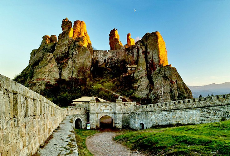
One of the most significant historical monuments in Belogradchik is the Belogradchik fortress. It’s occupies a strategic position between The balkam passages “Sveti Nikola” and “Kadu-Boaz”.
It has risen during the 1 st – 3rd A. D. centuries. For the better fortification in the first two centuries of their domination, the Romans tried hard to built a good fortifying system and comfortable roads. The fortress had to control this part of the road from Ratsiaria city (near today’s Archar village, Vidin district).
Romans built the highest part of the fortress called the Citadel. Some meters away from the fortress in southwestern direction, on a lonely, steep rock are the ruins from another ancient fortification that helped the Romans (The Latin fortress). The fortress was active also during the late antiquity .
The ruler of Vidin – Ivan Sratsimir (1356–1396) evaluated its strategic significance. During his time it was additionally reinforced and enlarged. Also in 1396 the fortress was captured by Ottomans and partially destroyed.
The overall reconstruction and enlargement has been started in 1805 and was completed in 1837. The fate foreordained an important role to this fortress during the Serbian – Bulgarian war or 1885, when under its walls were defeated the Serbian forces. The Belogradchik fortress situated at an altitude of 610 m above the sea level and consists of three yards with total area of 10 210 sq.m and one separate fortification.
A memorable view is revealed from the highest part of the fortress called First Plate.
Informations techniques
Profil altimétrique
Auteur de la donnée
