Waarschuwing

Waarschuwingen

Om te zien rondom
Zie meer
Open
Sluiten
Toon
Toon
Toon
Toon
Toon
Toon
Toon
Toon
Toon
Toon
Toon

Oups... Het lijkt erop dat Cirkwi geen toestemming heeft om uw locatie te gebruiken.

Presentatie
Kaart
Punten van interesse
Beoordelingen en recensies
Zie rondom

Le pont de la Flée

Le pont de la Flée
Le pont de la Flée
Le pont de la Flée
Le pont de la Flée
Le pont de la Flée
Le pont de la Flée
Le pont de la Flée
Le pont de la Flée
Le pont de la Flée
Le pont de la Flée

Technische informatie

Wandel
Moeilijkheid
Zeer eenvoudig
Duur
2h10mn
Afstand
4 km
Meer informatie tonen

Hoogteprofiel

Startpunt

Départ : parking de Lintre - Phiterne route de Sainte-Anne , 74700   Sallanches
Lat : 45.937445Lng : 6.602301

Punten van interesse

image du object

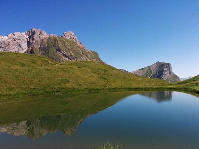
Hiking Trail: La Gouille des Fours Lake (2030 m)

A magnificent hike for experienced walkers in the heart of the Aravis, through mountain streams, waterfalls and alpine meadows, to the famous Gouille des Fours at 2,030 m. The loop return via the Col de Portette and Pierre Fendue offers beautiful panoramic views.Starting from the Lintre, Phiterne car park, this long loop takes you into a wild valley in the Aravis. The route climbs through the alpine meadows of Couterre and Marcolaz before reaching Lanchéron. The climb then becomes steeper and more rugged, with several exposed sections equipped with cables and ladders, before continuing through the alpine meadows towards Les Fours. The route then crosses a vast, lush green valley to the famous Gouille des Fours, at an altitude of 2,030 m. This small mountain pool, well known to the people of Sallanches, is associated with many local legends. Other small pools and wetlands can be found throughout the valley. When mist envelops the valley, the landscape takes on an almost mystical atmosphere, inviting the imagination to run wild. From the Gouille, the route continues to the Col de Portette, at 2,128 m, where, with a little luck, you may spot bearded vultures, chamois or ibex. The descent then leads through a vast scree slope before reaching the Chalets de Cœur and the Frédys alpine pastures. The route continues to the Pierre Fendue, offering beautiful views, particularly of Mont Blanc, before gradually descending alongside the mountain streams to the Pont de la Flée and Pont de Bellecombe, then returning to the starting point. Very difficult route for experienced hikers only. Some sections are steep, rugged, exposed and potentially slippery. The sections equipped with cables and ladders require good mountain experience. Snow patches may also remain at the beginning of the season.

Départ : parking de Lintre - Phiterne Route de Sainte Anne 74700 Sallanches
- Sallanches TOURISME -
Consulter

Datum en tijd

  • Vanaf 01/04/2026 tot 30/11/2026
  • Vanaf 01/04/2027 tot 30/11/2027

Aanvullende informatie

Environments

Platteland
Rivieroever
In het bos
Uitzicht op bergen
Waterkant
Panoramisch uitzicht

Updated by

Office de Tourisme de Sallanches - 15/10/2026
sallanchesmontblanc.com/
Report a problem

Open period

Van 01/04 tot en met 30/11.

Type of land

geprepareerde wandelwegen
Grond
steenslag
Geschikt voor alle terreinwandelwagens

Dieren

Ja

Gegevensauteur

Image Sallanches TOURISME
voorgesteld door Sallanches TOURISME
32 Quai de l'Hôtel de ville 74700 74700 - SALLANCHES France

Beoordelingen en recensies

Om te zien rondom
Zie meer
Open
Sluiten
Toon
Toon
Toon
Toon
Toon
Toon
Toon
Toon
Toon
Toon
Toon
Voorzichtigheid!
We hebben geen informatie over de moeilijkheidsgraad van dit circuit. U kunt onderweg enkele verrassingen tegenkomen. Voordat u vertrekt, aarzel niet om meer informatie in te winnen en alle nodige voorzorgsmaatregelen te nemen. Goede reis! 🌳🥾