Allarme
Allarmi
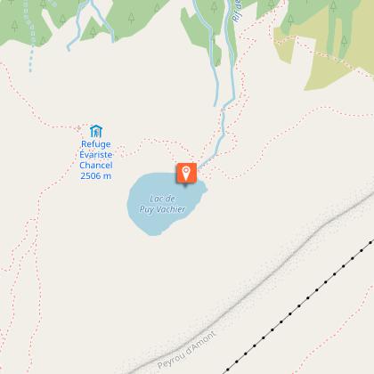
Rifugio Evariste Chancel e lago Puy Vachier da 2400 m di altitudine


Descrizione
La traversata verso il Rifugio, attraverso il lago Puy Vachier, offre un bellissimo panorama sui pascoli e sulle cime del versante meridionale della valle: l'altopiano dell'Emparis, le cime del Goléon e del Mas de la Grave, le Aiguilles d'Arves e i Trois Evêchés.
Dalla stazione intermedia delle funivie dei Ghiacciai della Meije,
a 2400 m, seguire le indicazioni per il lago Puy Vachier e il rifugio Chancel.
All'inizio, il sentiero scende per una sessantina di metri. All'incrocio con il sentiero che scende a La Grave, si svolta a sinistra sul sentiero che attraversa il fianco della montagna fino al lago.
Seguire poi il sentiero fino al rifugio Chancel, che richiede circa 30 minuti.
Il ritorno avviene per la stessa via.
Informazioni tecniche
Profilo altimetrico
Punto di partenza
Punti di interesse

Informazioni aggiuntive
Environments
Vista lago
Vista montagna
Updated by
Office de tourisme des Hautes Vallées - La Grave - La Clarée - L'Izoard - 24/06/2025
www.hautesvallees.com/la-grave/
Report a problem
Open period
Dal 01/05 al 31/10.
Contact
Phone : 04 76 79 90 05
Email : lagrave@hautesvallees.com
Animali
Sì
Autore dei dati
