Alert
Alerts
Description
Map
Ratings and reviews
See around
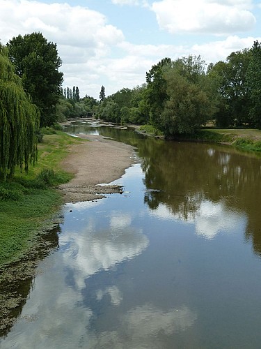
Le Louet
Credit
: Mairie Rochefort sur Loire
Description
Bras de Loire qui s'étend sur une trentaine de kilomètres entre Juigné sur Loire et Chalonnes sur Loire, ce cours d'eau était une voie navigable très fréquentée jusqu'au début du XXème siècle. On y transportait beaucoup de marchandises comme le vin et le bois, sur les gabares et les futreaux. Il y existait aussi des bacs qui permettaient de traverser le Louet ou la Loire.
Technical Information
Lat, Lng
47.3592489-0.6553817
Coordinates copied
Altitude
15 m
Uncertain state
Point of Interest updated on 27/08/2019
This point of interest hasn't been updated recently, which could compromise the reliability of this information. We recommend that you inquire and take all necessary precautions. If you're the author, please verify your information.
Altimetric profile
IGN cards

1522ET - ANGERS
Editor : IGN
Collection : TOP 25 ET SÉRIE BLEUE
Scale : 1:25 000
13.90€

TOP100D49 - MAINE-ET-LOIRE ANGERS SAUMUR CHOLET VALLÉE ET CHÂTEAUX DE LA LOIRE PNR LOIRE-ANJOU-TOURAINE
Editor : IGN
Collection : TOP 100
Scale : 1:100 000
8.40€

D53-72 MAYENNE SARTHE
Editor : IGN
Collection : CARTES DÉPARTEMENTALES IGN
Scale : 1:150 000
5.90€

D49 MAINE-ET-LOIRE
Editor : IGN
Collection : CARTES DÉPARTEMENTALES IGN
Scale : 1:150 000
5.90€

NR07 PAYS DE LA LOIRE
Editor : IGN
Collection : CARTES RÉGIONALES IGN
Scale : 1:250 000
6.80€

NR06 BRETAGNE
Editor : IGN
Collection : CARTES RÉGIONALES IGN
Scale : 1:250 000
6.80€

801 FRANCE NORD OUEST
Editor : IGN
Collection : CARTES NATIONALES IGN
Scale : 1:320 000
6.10€

EUROPE
Editor : IGN
Collection : DÉCOUVERTE DES PAYS DU MONDE IGN
Scale : 1:2 500 000
7.00€
Data author

proposed by
Office de Tourisme Anjou Vignoble et Villages
Place de l'Hôtel de Ville 49290 Chalonnes-sur-Loire France
Ratings and reviews
To see around