Tours
Activities
Places of interest
Where to eat
Where to sleep

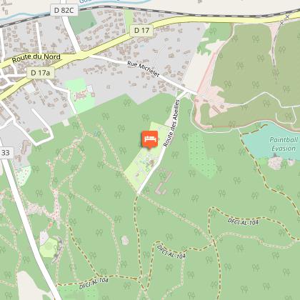
Camping Marie Rose: Explore Noves and Its Treasures

Are you the owner?
Nestled in the heart of Provence, in the charming village of Noves, Camping Marie Rose serves as the perfect base for discovering the wealth of the Bouches-du-Rhône region. Surrounded by lavender fields and olive groves, enjoy the multitude of outdoor activities the area has to offer.\n\nVisit famous cultural sites like the Palais des Papes in Avignon, just a 15-minute drive away, or stroll throug...See more

Walking around CAMPING MARIE ROSE

See more suggestions
Hiking trails in the CAMPING MARIE ROSE area.
See more suggestions
SAINT REMY DE PROVENCE - Pèr draio e pèr Camin in mountain bike
6.4 km

SAINT REMY DE PROVENCE - Pèr draio e pèr Camin in mountain bike

By drailles and by paths, follow the tracks of the transhumance of the Alpilles shepherds and their flocks! Back to the car park, take the path on the left, follow it for 3.5 km and pass a panel of communal decree. At the next intersection, turn left. Go right on the white gravel path and follow it to the road. 1- Turn left, pass the water tower and in the bend turn on the 2nd street on the left. Go down to the roundabout. Take the 2nd exit and take the avenue on the left. Turn left and cross the Liberation and Saint-Paul squares to reach the Bergerie. 2- Retrace your steps and take a right on the street just before the pharmacy. At the intersection, stay left and continue to the canal. Follow it on the right. At the end of the road, turn right. Turn left and pass the Roumanille manade. 3- Climb the path to the right and pass the canal. Once the hill is completed, switch on the path to the right. Take the road on the right, then turn left on the path of Mas de Bedoc. At the intersection, turn left on the path. At the end, turn left on a road. Follow it until you reach the D30b. 4- Continue towards Noves. After 300 m follow the Abeies path on the left, then the Crêtes path. At the end, take on the left the D30b to join Noves and the D30. Turn to the left. Follow the direction Châteaurenard and pass three roundabouts. After the 3rd, go left the medieval gate. 5- Just after, turn right, join the Pagnel square and continue Paul Auran street. At the end, turn right, then direct left. Take the D30b on the right. 1 km further, take a path on the left (n°941). At the end, turn left, cross the river and turn right (Mas Vert). Follow this path for 2 km. 6- Follow the road to the right. Go The river and at the intersection, take to the right. After 700 m, fork left on the Chicard de Pouvarel draille. Borrow the 1st road on the right. Go up the road on the left and join point 4. Follow the path of Transhumance on the left. Continue straight for 7.5 km to return to the starting point.

4 h
32 km
Medium
Show
SAINT REMY DE PROVENCE - Cycling from the Alpilles to Val d'Enfer
8.4 km

SAINT REMY DE PROVENCE - Cycling from the Alpilles to Val d'Enfer

Go through the ages with the exceptional historical heritage of the Alpilles! From the Inter communal Tourist Office of Saint-Rémy-de-Provence, take the D5 towards the Glanum site to the junction with Joseph d'Arbaud Avenue. 1 - Turn right on the avenue. Continue straight on "Chemin Gaulois" to the irrigation canal. Turn left after the canal, then take the old road on the left to Arles until the intersection with the D27. 2 - Take the D27 left towards Les Baux-de-Provence. Climb the road for 4 km, then go down the Val d'Enfer to Baux-de-Provence. 3 - Continue on the D27 towards Maussane-les-Alpilles to the junction with the D78f. Turn left and continue until the intersection with the D17 in the heart of Maussane-les-Alpilles. 4- Cross the D17 and continue on the way to the pine forest. At the crossroads of the D78c, take it on the right. Continue to the center of Paradou and the intersection with the Belle Croix road. 5 - Turn left on Belle Croix road and continue for about 5 km until you reach the D33. 6 - Turn right towards Fontvieille, until you reach the junction with the D17a. Cross this crossroads and continue towards Saint-Etienne du Grès 7 - (Caution!) At the intersection with the D33a, turn left and continue using the coloured shoulder to the Saint Gabriel chapel. 8 - Just after the chapel, turn right on the D32, always towards Saint-Etienne du Grès. Cross the village, past the town hall. 9 - Before the exit of the village, take on the right the little path of Notre-Dame-du-Château. 10 - After a small bridge, take on the left the path of Calanquet. Continue for 700 m then at the crossroads with the D31, turn right and continue to the center of Saint-Rémy-de-Provence. At the church, turn right to join the departure car park.

4 h
41 km
Medium
Show
SAINT REMY DE PROVENCE - The Alpilles ridge
9 km

SAINT REMY DE PROVENCE - The Alpilles ridge

Take full view, during this sensational circuit that will take you to discover the Alpilles in all their facets! The burial works of the High Voltage line of the Caume, Saint-Rémy-de-Provence will take place between 18/09/2017 and 22/12/2017, down from the telecommunication relay to the Plaines car park. Diversion routes will be set up except for the portion between Vallon de Valrugues and the plateau, on the route of Gr6, which will be completely closed for a few weeks. Consult the map of the works on the Park's website for more details. From the Antiques car park, along the D5 towards Saint-Rémy-de-Provence, and turn right to join the Cloister of Saint Paul Mausole, at the end of the path lined with plane trees. 1- Facing the Cloister, follow the road on the right to bypass it. At the Relais Information Service panel of the Alpilles Regional Nature Park, take Chemin des Carrières on the right. Follow the marked path PR (in yellow), which crosses valley and forest. 2- At the crossroads with the small paved road, follow it to the left. Continue on the road to the telecommunication tower of the Caume plateau. At the tower, turn left towards GR®6. After the sign of "Biotope", follow the ridge line to the right by a series of rocky steps. 3- After 2 km, turn to the right following the GR®6 and join the foot of the peaks. Continue between rocky passages and undergrowth to the Vallongue pass and its rocky gorge. Go down to the left to a road near the airfield (some passages require the hands). 4- Take the path on the left. From this point the circuit will be double marked PR (yellow) and GR® (red / white) until arrival. Continue for 3 km, remaining attentive to the marking, until a junction of marked paths and a property lined with walls. 5- Turn left and walk 500 m. Take a track on the right and then a small asphalt road. At the hairpin bend, turn left onto the path lined with properties. 6- At the fork stay on the right, further pass a barrier then continue to a stone cottage. After the shed, turn left. Cut the path where the GR®6 passes, go up between two wooden barriers and continue to the right on the path that joins the starting point.

6 h
16 km
Hard
Show
The Routo of Baume Brignolle
9.2 km

The Routo of Baume Brignolle

Take a stroll among the peaks and valleys of Baume Brignolle to discover the richness of the Alpilles! From the car park of the bridge said to be Roman, cross the ford and start hiking through the wooded path. Continue until you leave the shaded area to reach the fruit cultivations. 1 – Head towards the Chateau Romanin on the left after crossing the vineyards and tree crops to either side of the path. Before reaching to the castle, follow the trail marked in red and white (GR6®) which plunges to the left and climb to the Col de la Vallongue. Then turn right and continue along the narrow stony path, first at the foot of the ridges and then all along them. 2 – Enter the zone for biotope protection, covered by prefectoral decree. Turn left at the crossroads after taking a few steps in the middle of the surrounding vegetation, and follow the trail to leave the pylon on the right. Continue straight. Across the telecommunication antenna, follow the road that continues downwards to leave the plateau of Caume. 3 – Below the plateau, continue straight at the first intersection before turning left at the next intersection to take the Chemin de Baume Brignolle. After 800m, at the crossroads where 6 paths meet, follow the second path to the left, it is the DFCI AL 115 track. Continue on Chemin de Baume Brignolle until you reach on the D24. 4 – Continue straight along the main road. Preferably, take the small path which is on the left. Continue until the crossroads between the D24 and the D25. 5 – At the intersection at the bridge, follow the D24 towards Eygalières until the bridge saidRoman bridge, end point of the hike.

6 h
19 km
Hard
Show
Petit et Gros Calans
9.3 km

Petit et Gros Calans

Climb the heights of Eygalières, to appreciate the beauty ofthe Calans of the Alpilles massif ! From the parking, follow the D24b towards the city center. At the crossroads, turn right. Then leave the town hall on the left. 50 m further, leave the Monument to the dead on the left and continue along the road.1- Turn left on the path Ludovic Souvestre, and take the first right. Cross the locality of the 4 vents and continue on the path. Once at the Badon Arboretum, go around it on the left and follow the trail. 200 m after the barrier, take the small rocky path on the left. 2- At the directional sign "Balade du Gros Calan", turn left and follow the massif on the stony path. In the bend, continue on the path, leaving the small path on the left. 3- Go past the green tank in the hairpin bend, then turn right immediately onto the gently sloping trail at the concrete tank. Follow it to the junction with the D25.4- Cross the departmental and take the path on the right in the pine forest. Then walk along the road for 350 meters (Caution, traffic!). Leave the road after the turn to take the wide path that goes on the right. Continue for 200 meters until you reach a fork, then go right up the path that continues towards the hill. Follow this zig-zag path for 1.5 km. 5- Engage in the small path that sinks to the right of the path. The latter leads to a new trail. Leave the different paths that leave from both sides to join the D25. Cross it again. Then climb the main path after crossing the barrier. 6- At the height of the tank, continue straight on the track which descends gently. After the bend, take the left path at the next junction. Follow this path along the Petit Calan then continue in the forest. 7- Cross the barrier and take the small path on the right that runs along the road for about 700 m. Turn right at the crossroads, and continue on the path. Go past the well and continue on the main road to the D24b. 8- Cross the departmental road and continue on Mario Prassinos road. Go behind the cemetery and enter Eygalières. At the top of the small hill, turn right. Possibility to fork then directly to the parking lot or to walk in the village.

5 h
13 km
Medium
Show
Stroll of the Petit Calan
9.3 km

Stroll of the Petit Calan

On the heights of Eygalières, go through the GR®6 between the Calans and admire breathtaking views of the Alpilles. From the parking, follow the D24b towards the city center. 1- At the crossroads, turn right. Follow the red and white markings until the end of the hike. Then leave the town hall on the left. 50 m further, leave the Monument to the dead on the left and continue along the road. 2- Turn left on the path Ludovic Souvestre, and take the first right. Cross the locality of the 4 vents and continue on the path. 3- At the Badon Arboretum (possibility to climb to the point of view), go around it and follow the path. 200 m after the barrier, take the little rocky path. 4- At the end of the track, turn right, leaving the Gros Calan behind. Continue on the forest path to the cistern. 5- At the height of the tank, turn right on the slope which goes down gently. After the bend, continue on the left path at the next junction. Follow this path along the Petit Calan then continue in the forest. 6- Cross the barrier and take the small path on the right that runs along the road for about 700 m. 7- Turn right at the crossroads, and continue on the path. Go past the well and continue on the main road to the D24b. Cross the departmental road and continue on Mario Prassinos road. Go behind the cemetery and enter Eygalières. 8- At the top of the small hill, turn right. Possibility to fork then directly to the parking lot or to walk in the village.

3 h
9.2 km
Easy
Show

What to do in CAMPING MARIE ROSE

See more suggestions
The best experiences in CAMPING MARIE ROSE are just a click away, book now.
See more suggestions
Lavender Fields and Tour of the L’Occitane© Factory
14 km

Lavender Fields and Tour of the L’Occitane© Factory

During the lavender blossoming season, discover the beauty of the fields in bloom along the Provençal countryside! Be swept away by the colours and scents in the different villages before visiting the famous cosmetics factory, “L’Occitane©”.  DURING THE LAVENDER BLOSSOMING SEASON (JUNE 15 TO AUGUST 15), DISCOVER THE BEAUTY OF THE FIELDS IN BLOOM ALONG THE PROVENÇAL COUNTRYSIDE. BE SWEPT AWAY BY THE COLOURS AND SCENTS IN THE DIFFERENT VILLAGES BEFORE VISITING THE FAMOUS COSMETICS FACTORY, “L’OCCITANE©”. Start your day with a tour of Valensole, the entrance to the regional Nature Park of Verdon. Follow the “Lavender Routes” for a sensory experience that can only be had in Provence. Discover the colourful summer landscape, combining the blue from the lavender with the gold from the wheat.  Then, journey to Moustiers Sainte Marie, located at the gates of the Verdon Gorges measuring 630 metres high. Spend a pleasant moment in this charming pottery town, registered as one of the most beautiful villages in France. Your guide will then take you along the Lake of Sainte Croix, recognised for its wooded environment and Provençal fragrance due to the neighbouring fields of lavender, thyme and rosemary. Appreciate this relaxing moment in a natural and preserved environment. End your Provence-themed day with a guided tour of the l’Occitane© factory, the famous and world-renowned cosmetics brand, before heading back to Avignon on your minibus. 

Cours Jean Jaurès 84000 Avignon
Book from 110 EURBook
Show
Provençal Excursion: Discover the lavender fields and the hilltop villages
14 km

Provençal Excursion: Discover the lavender fields and the hilltop villages

Meander through the Provençal countryside by minibus on a one-day trip! Explore the wonderful hillside villages and marvel at the landscapes of the lavender fields and the olive trees!   Start your trip by visiting Roussillon; this village ranked as one of France's most beautiful will captivate you with its variety of colours! Perched upon an ochre cliff, this village offers breathtaking panoramic views of the region. You will be charmed by this picturesque village!  You will enjoy its Provençal market (Thursday). Your next stop is to the medieval village of Gordes. This town built entirely of "Lauze" stones will amaze you with its architecture and typical regional atmosphere! Discover Gordes market (Tuesday). Next, visit Fontaine de Vaucluse and discover where the Sorgues starts. Then, head to see the amazing Gard bridge. Admire the architecture and the vestiges of the Nimes aquaduct, which is listed on UNESCO's World Heritage List. Following the aquaduct, the tour will go to the village of Baux de Provence. Situated on the top of a hill, enjoy the spectacular view of the surrounding landscape, and let yourself be charmed by the authenticity of the village! From here drive to Saint Remy de Provence, and stop along the way to photograph the famous  "Les Antiques" which are known for their triumphal arc and Roman mausoleum. If you take the tour on a Sunday, you will enjoy an extra visit to Isle sur la Sorgue. Explore this village famous for its charming antique shops and its Provençal market! At the end of the day, you will return to Avignon accompanied by your driver. Through this tour you will discover the Provençal way of life and the region's magnificent landscapes!

Cours Jean Jaurès 84000 Avignon
Book from 130 EURBook
Show

What to visit in CAMPING MARIE ROSE

See more suggestions
Enjoy the green spaces of CAMPING MARIE ROSE.
See more suggestions

Where to eat in CAMPING MARIE ROSE

See more suggestions
Establishments in CAMPING MARIE ROSE offer dishes for all tastes.
See more suggestions

Where to sleep in CAMPING MARIE ROSE

See more suggestions
Discover available accommodations around CAMPING MARIE ROSE.
See more suggestions
Caution!
We have no information on the difficulty of this circuit. You may encounter some surprises along the way. Before you go, please feel free to inquire more and take all necessary precautions. Have a good trip! 🌳🥾