Alert
Alerts
The ladder path


Description
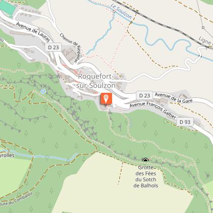
This path offers stunning panoramic views over the Larzac, then on the Tournemire amphitheatre and over the village of Roquefort which are the highlights of this hike that provides a glimpse of pastoral life in the past.This is where the name of the path “the ladder path” originates from. Due to a number of landslides, the path has been diverted towards the far end of the Combalou plateau and now follows a staircaseFrom the Tourist Office carpark, walk across the road near the bus stop and walk up the rising path running alongside the graveyard. When the path meets the tarmacked road, turn right then first left following the hairpin bend. 300 m further on, take the fork to the left up to a drinking water fountain.Take the small path that slopes up to the right towards the Combalou plateau.At the base of the scree, first walk uphill to your right, then scale across it.Once you get across the scree, carry on along a marked path that joins a track through box trees following the contour line.When you arrive at the far end of the Combalou, walk uphill until you reach the pierced rock and take the metal staircase.When you get to the plateau, head East in the direction of the relay masts, once you have reached them, carry on to your right for 200 m and at the hairpin bend fork to the left on the path that leads to the jasse (sheepfold).Walk between the Jasse and the edge of the plateau, keep on walking along the plateau and take a trail through the pinewood. Start walking downhill until you reach the Aiguières pass.Head towards Roquefort and carry straight on past the “Sotch de Balhols” (large geological fault) and walk down to the Saint-Pierre chapel (a flight of steps to the left gives access to a viewpoint indicator). Once you’ve enjoyed the view, descend the steps, and then go to your left down the Créance street and then up the Baragnaudes street which rises up onto the opposite side towards the Quille des Baragnaudes which are impressive vertical monoliths. Walk past the Quilles, then along the cliff and climb down the steps.At the bottom of the steps, take the right and immediately after turn to the left to pass under a porch to get back to the avenue de Lauras that will lead you to the Tourist Office from where you started your hike.
Technical Information
Altimetric profile
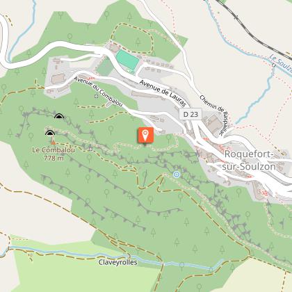
Starting point
Steps
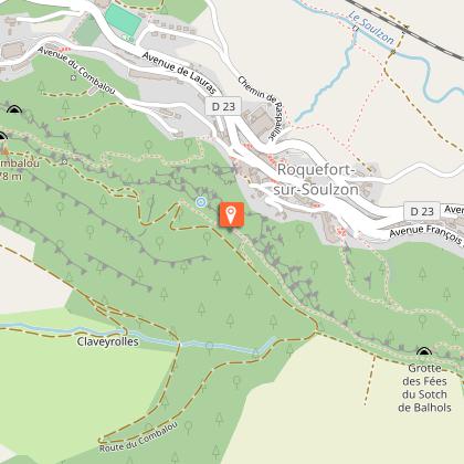
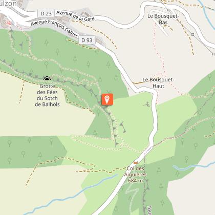
Points of interest


Additional information
Public transport
Travel by bus or train: lio.laregion.fr/carpooling : BlaBlaCar, Rézo Pouce, Mobicoop, Idvroom, LaRoueVerte, Roulez malin
Advice
Box tree moths are active from May to October. During the caterpillar phase, they feed on the leaves of box trees. They crawl down trees and move on long silken threads, although these threads are annoying when hiking they do not pose any health risk
Is in the midst of the park
This itinerary is located in the World Heritage zone Causses and Cévennes, mediterranean agropastoral cultural landscape.
Advised parking
Tourist Office
Access
Situated 25 km southwest of Millau via the D 992, D 999 and D 23 roads towards Albi, and 14 km from St-Affrique via the D999 road towards Millau.
Arrival
Tourist Office
Ambiance
A long time ago, an employee of the Mas de Roquefort farm used to bring a meal to the shepherd who was grazing his sheep on the Combalou plateau. He had to take a short-cut escalating two ladders to reach the top of the cliff, hence the name of this path which offers a wealth of discoveries such as the Balhol sinkhole, the Combalou jasse and the 11th century chapel Saint-Pierre built on a rocky spur.
Departure
Tourist Office
Data author
