Alert
Alerts
Exploring the hamlets of Vallouise and Pelvoux


Description
A trail to discover the secret charm of the hamlets of the Pays des Écrins.
Waysigning: one green dot and once white dot
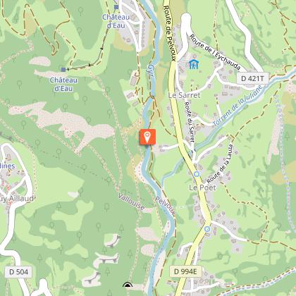
From the Park Centre ("Maison du Parc"), follow the road to Puy Saint-Vincent.
Take the path on the left towards Les Parchers and continue heading in this direction. The track runs above the Gyronde and then comes to a bridge below the hamlet of Le Grand Parcher. Cross this bridge and then cross the D994E (take care) and follow the narrow road leading up to this hamlet.
A short distance beyond the chapel, take a path on the left to Petit Parcher. Join the road right and follow this for a short distance.
Take the path for La Casse. Carry on up through La Casse and, at the top where the houses come to an end, take the path leading to the Rocher Pointu. Further on, continue straight ahead towards the Rif Paulin and Pelvoux-Le Sarret. Cross the Rif Paulin mountain stream over a sill and then continue along the canal.
Head down towards Pelvoux - Le Poët. At the lower end of the hamlet, cross the mountain stream La Juliane via a narrow road and then drop down to the D994E.
Cross the D994E (take care) to take the track opposite which leads to the Gyr mountain stream. Stay on the left-hand bank and follow the track leading to Vallouise.
Cross the Gyr to carry on along its right-hand bank, passing close to the campsite, to return to the Park Centre.
Technical Information
Altimetric profile
Starting point
Points of interest


Additional information
Public transport
Public transport >> www.pacamobilite.fr Consider car-sharing >> www.blablacar.fr For more information, ask at the Tourist Information Office nearest to the trail starting point.
Advice
It is possible to complete only some sections of this loop. In particular, at the Rif Paulin you can drop back down to Vallouise via Pra Peyron or, instead, park at the Vallouise cemetery car park, set off from Rivière Pont, climb up via Pra Peyron to reach the Rif Paulin and, from there, carry on towards Le Poët and return to Vallouise following the described route. Check weather conditions before setting off. Rescue services contact details: Secours Montagne (Mountain Rescue): +33 (0)4 92 22 22 22 or 112 Show consideration for the work of farmers, livestock keepers and owners Close all gates behind you Take your litter home Do not take shortcuts across pastureland
Advised parking
Park Centre car park, Vallouise
Access
9 km from L'Argentière-La Bessée, take the D994E.
Arrival
Park Centre ("Maison du Parc"), Vallouise
Ambiance
“You think you know the hamlets of Vallouise and Pelvoux when you go there by road. But approaching them via the footpaths is another experience altogether. Not to mention the pleasure of walking on these little-trod paths.” Marie-Geneviève Nicolas, park ranger at the Parc National des Écrins
Departure
Park Centre ("Maison du Parc"), Vallouise
Data author
