Alert
Alerts
Hiking trail: Tour des Aravis, facing Mont-Blanc (4 days & 3 nights)

Description
A sporty way to unwind in the mountains, facing Mont Blanc.
Sallanches and Cordon Tourisme offer you an exceptional 4-stop hiking tour: 4 days / 3 nights in the Aravis massif.
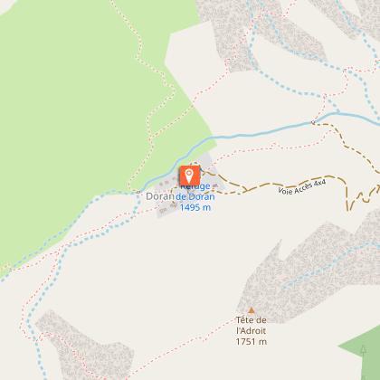
DAY 1: Sallanches center ville (550 m) - Burzier (970 m) - Refuge de Doran (1495 m)
Meet in Sallanches, at the SNCF station if you're arriving by train, or in the Rosay parking lot if you're leaving your car. The route starts in front of the Sallanches train station. Climb up to Burzier, then to the Doran mountain pasture, where you'll find its chapel, its alpagistes and its refuge.
DAY 2: Alpage de Doran (1495 m) - Les Quatre-Têtes (2364 m) - Alpage de Mayères (1563 m)
Head up the Doran valley, at the foot of Pointe Percée, the highest point in the Aravis massif. At the Col de Doran, make the round trip to the Quatre-Têtes summit, then descend via Lanchéron towards the Mayères mountain pasture and its altisurface. Overnight at the Tornieux refuge.
To do less! Reach Mayères via the Arête des Saix (1851 m)
without passing through Quatre-Têtes.
DAY 3: Alpage de Mayères (1563 m) - Col de Niard (1801 m) - Plateau des Bénés (1723 m) - Tête Noire (1691 m) - Village de Cordon (870 m)
Balcony trail, at the foot of the Cascade des Fours, up the Vallée de Coeur. Meet the mountain farmers before reaching the Col de Niard and the Cabane du Petit Pâtre. Cross the Bénés plateau, then descend to the village of Cordon. Pass through Abérieux to visit the farm and watch milking (not before 5.30pm). Your choice of accommodation in one of the village's B&Bs or hotels, or in the hills above.
To do more! Go up the Vallée des Fours instead of the Vallée de Coeur, and join the Gouille des Fours itinerary down the Col de Portette.
DAY 4: Village de Cordon (870 m) - Petit Croisse-Baulet via Bornes Romaines (2009 m) Sallanches Centre ville (550 m)
Climb to Col de l'Avenaz, then take the Roman milestones path to Petit Croisse Baulet and Col de Jaillet, which links the Communes of Cordon, Sallanches, Combloux and La Giettaz. Descend along the Sentier Découverte de la Forêt to Lezaive, where you pass along the right bank of the stream to Nant Cruy. Reach Sallanches town center
by the Bois de Fessy path.
To do more! From the Col de l'Avenaz, return to the "Grand" Croisse-Baulet (2236 m).
To do less! Complete the entire loop of the Sentier de Découverte de la Forêt (1400 m) and then take the downhill route.
Technical Information
Altimetric profile
Starting point
Points of interest

Date and time
- From 15/05/2026 to 15/10/2026
- From 15/05/2027 to 15/10/2027
Additional information
Open period
From 15/05 to 15/10 daily.
Subject to refuges being open.
Updated by
Office de Tourisme de Sallanches - 16/04/2026
www.sallanchesmontblanc.com
Report a problem
Contact
Phone : 04 50 58 04 25
Email : tourisme@sallanches.com
Website : http://www.sallanchesmontblanc.com
Facebook : https://www.facebook.com/SallanchesMontBlanc
Type of land
Non-groomed itinerary
Rock
Stone
Ground
Grit
Not suitable for strollers
Location complements
Departure is from the station, but if you arrive by car, you can park at the P+R parking lot at the northern entrance to Sallanches and take a bus to the station (Y83, Y84 or Y85), or park for free at the Rosay or Lévaud gymnasiums.
Topo guides and map references
Map references :
Map IGN 3430ET - LA CLUSAZ LE GRAND-BORNAND
1:25,000 hiking map "Belvédères du Mont-Blanc" on sale at tourist offices for €7.
Tricky passages
day 2: the summit of the Quatre Têtes is an aerial climb for sensitive persons
Animals
Yes. on a leash in mountain pastures
Data author
