Alert
Alerts
Walking route: Tavaneuse Lake loop from Prétairié


IGN cards


Description
During this hike, discover one of the lakes of Abondance, Lake Tavaneuse, renowned as one of the most beautiful in the Chablais region.
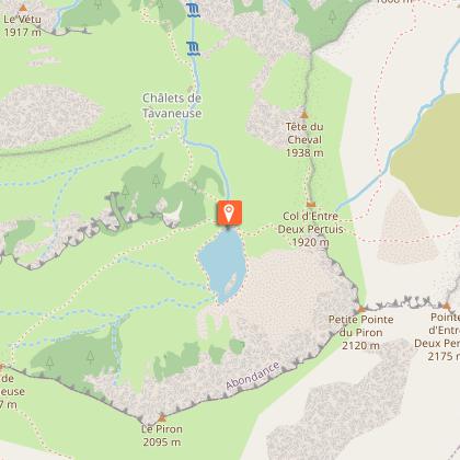
This hike takes you to a mountain lake: Lac de Tavaneuse, 1806 m above sea level. You'll cross mountain pastures and discover their chalets.
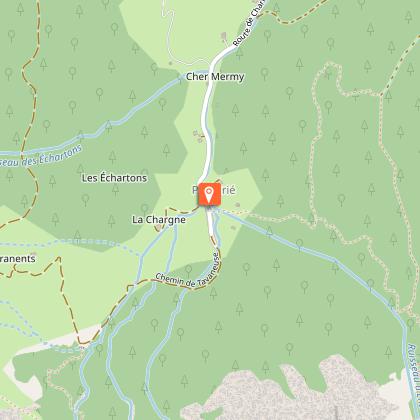
The hike starts from the Prétairié parking lot. Take the path towards the Tavaneuse chalets. Then head towards Lac de Tavaneuse.
Once there, enjoy the lake and its clear waters. Picnics are a welcome way to enjoy the lake.
Technical Information
Altimetric profile
Starting point
Steps
Points of interest


Date and time
- From 01/06/2026 to 15/10/2026
Additional information
Open period
From 01/06 to 15/10 daily.
Check with tourist offices in advance to find out the current access conditions.
Subject to favorable snow and weather conditions.
Sustainable tourism
To respect farming practices, natural areas and wildlife, please keep your dogs on a lead and pick up after them. Keep and sort your rubbish, stay on the paths and close the fences.
Updated by
Office de Tourisme Leman Mountains Explore - 06/12/2025
leman-mountains-explore.com
Report a problem
Environments
Lakeside or by stretch of water
Mountain view
Forest location
Waterside
Lake view
Sensitive Natural Area
Village 2 km away
Contact
Phone : 04 50 73 02 90
Email : abondance@ot-peva.com
Website : https://leman-mountains-explore.com
Type of land
Stone
Ground
Grit
Not suitable for strollers
Location complements
The start of the hike is a 10-minute drive from the center of Abondance village. Follow signs for Prétairié. Park at the parking lot at the end of the road.
Topo guides and map references
Topo guides references :
Hiking maps and guidebooks are available for purchase at tourist offices throughout the Evian and Abondance Valley region.
Map references :
- Map guide to 65 walks and hikes in the Evian region and Abondance valley
- Map of walking routes in the Portes du Soleil area in France and Switzerland
- IGN TOP 25 No. 3528 ET Morzine Chablais Massif Portes du Soleil
Reception complements
Whatever your hike, remember to take cereal bars, sufficient water, sunglasses, sun cream, a small first aid kit, as well as clothes adapted to your outing according to the season and the weather forecast.
Guidebook with maps/step-by-step
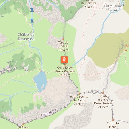
0/ "Prétairié" parking lot. 1/ From the parking lot, follow the path to an intersection followed by a small bridge. Head towards Lac de Tavaneuse. You'll pass the Tavaneuse chalets. 2/ At the lake, turn left and follow the signs for "Col Entre Deux Pertuis". 3/ Go downhill as far as the intersection, turn left and follow the signs for "Chalet d'Entre Deux Pertuis". 4/ Continue downhill until you enter the forest. At the intersection, take the left-hand path. Continue down through the woods until you reach the starting point.
Animals
Yes. Dogs must be kept on a leash due to the presence of livestock and wildlife.
