Alert

Alerts

To see around
See more
Open
Close
Show
Show
Show
Show
Show
Show
Show
Show
Show
Show
Show

Oups... It would appear that Cirkwi does not have permission to use your location.

Presentation
Description
Map
Points of interest
Ratings and reviews
See around

Walking itinerary: Tour des Cornettes de Bise

Walking itinerary: Tour des Cornettes de Bise
Tour des Cornettes de Bise
Tour des Cornettes de Bise - La Chapelle d'Abondance
Regulations Protected natural area

Description

A beautiful hike which starts from the centre of the village of La Chapelle d'Abondance and offers superb views of the Cornettes de Bise, the village and the valley of Abondance.

This hike takes place in the natural reserve of the Cornettes de Bise, a Natura 2000 site.

The Cornettes tour offers magnificent views of the French and Swiss Chablais mountains.

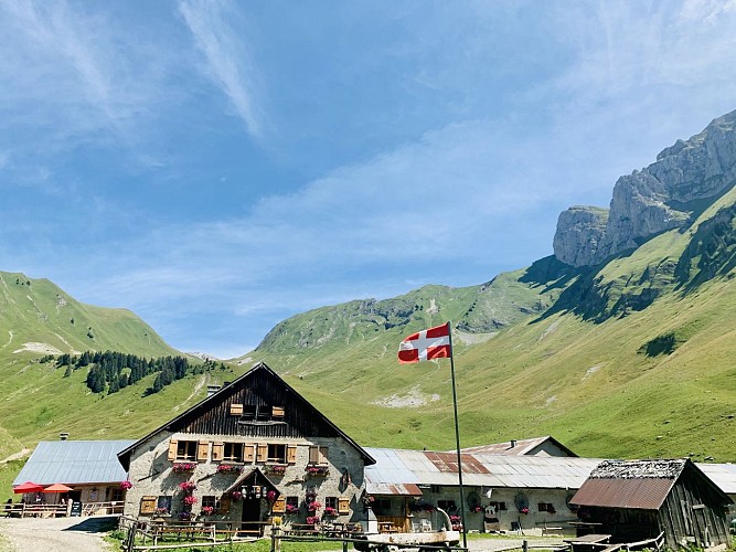
Starting from the Bise mountain pasture, you'll head for the Pas de la Bosse. You'll pass several alpine chalets: Chalet de la Bosse, Chalets de Cheneau and Chalets Toper.

You then reach the Col de Vernaz at 1815 m altitude. You then descend on the Swiss side and follow the north face of the Cornettes de Bise.

You then reach the Col d'Ugeon at an altitude of 2018 m.

The descent is via Planchamps to the Bise chalets.

You may even spot ibex, of which there are many in this reserve!

Technical Information

Walking
Difficulty
Hard
Duration
6h10mn
Dist.
12 km
Show more

Altimetric profile

Starting point

Alpage de Bise , 74360   La Chapelle-d'Abondance
Lat : 46.330221Lng : 6.766232

Points of interest

image du object

Cornettes de Bise summit

The Cornettes de Bise massif is located between the Abondance valley and the Tanay valley, in Switzerland. Located in the town of La Chapelle d'Abondance, it peaks at 2432 m above sea level and is part of the Natura 2000 network.Chamois, mouflons, golden eagles and notably the Alpine ibex, whose (border) population is estimated at around 700 individuals, can be seen on this massif. Certain species, such as the blue thistle, are also abundant on the site, but are nevertheless rare in France or in Europe. The angular relief of the Cornettes de Bise is composed of hard limestone rocks. The slopes are steep, even abrupt, with numerous rocky bars and scree. By decree of 2 August 2013, the Cornettes de Bise is a classified site because of its picturesque character. A classified site is a remarkable natural area whose historical, artistic, scientific, legendary or picturesque character requires, in the name of the general interest, that it be preserved in its current state and that it be protected from any serious damage (destruction, alteration, trivialisation, etc.). Natura 2000 is a network of protected natural sites throughout Europe, identified for the rarity or fragility of their wild species and the natural habitats that shelter them. The aim is to preserve the biodiversity of these areas in the long term without banning all human activities and to enhance the natural heritage of the area. Natura 2000 is not a nature reserve in the strict sense.

Route de Chevennes 74360 La Chapelle-d'Abondance
- Office de Tourisme Pays d'Evian Vallée d'Abondance -
Consulter
image du object

Tourist Information Office of La Chapelle d'Abondance

The tourist information office is at your disposal for all information about the resort-village and its surrounding villages in the Evian-Vallée d'Abondance region and neighboring Switzerland.The tourist information office and its advisors welcome you all year round and offer the following services: - tourist information on La Chapelle d'Abondance and its summer and winter activities - tourist information on the Evian-Vallée d'Abondance region, the Portes du Soleil and the surrounding area in France and neighboring Switzerland - central availability database for furnished rentals - accommodation options: furnished accommodation, bed and breakfast, gîtes, hotels, vacation centers, tourist residences, refuges - pay station for winter ski passes and summer passes purchased on skipass.lachapelle74.com - A wide range of maps and topo-guides, free or on sale: hiking, trail, mountain biking, road biking, climbing, via ferrata, snowshoeing, ski touring (IGN map, Portes du Soleil hiking map, topo guide to walks and hikes in the Vallée d'Abondance, topo Chablais Grimpe). - ticket sales for various tourist services: events, visits and activities - sale of fishing cards - sale of 10-trip EVA'D bus passes - sale of Swiss motorway vignettes - Abondance cultural center tickets: Abbey of Abondance and Maison du Fromage Abondance - CGN (Compagnie Générale de Navigation sur le lac Léman) ticket office - Chaplin's World Museum ticket office in Vevey (Switzerland) - Aquaparc ticket office in Le Bouveret (Switzerland) - Swiss Vapeur Parc ticket office in Le Bouveret (Switzerland) - ticket office Fort de Chillon in Veytaux (Switzerland) - guided hiking outings (December to March - July and August) - ski touring ticket office (December to March) - guided Via Ferrata and rock-climbing outings (July and August) - tickets for guided cultural tours (all year round) - goodies, souvenirs, posters - Pocket Wifi rental - linen rental in partnership with supplier Resalinge - photocopying and scanning service - free public Wifi connection

10 route des Frasses Maison des Soeurs 74360 La Chapelle-d'Abondance
- Office de Tourisme Pays d'Evian Vallée d'Abondance -
Consulter

Date and time

  • From 01/06/2026 to 15/10/2026

Additional information

Open period

From 01/06 to 15/10 daily.
Check with your local tourist office for current access conditions.

Subject to favorable snow and weather conditions.

Updated by

Office de Tourisme Leman Mountains Explore - 24/11/2025
leman-mountains-explore.com
Report a problem

Environments

Mountain location

Contact

Phone : 04 50 73 51 41

Email : lachapelledabondance@ot-peva.com

Website : https://leman-mountains-explore.com

Type of land

Rock
Stone
Ground
Grit
Not suitable for strollers

Location complements

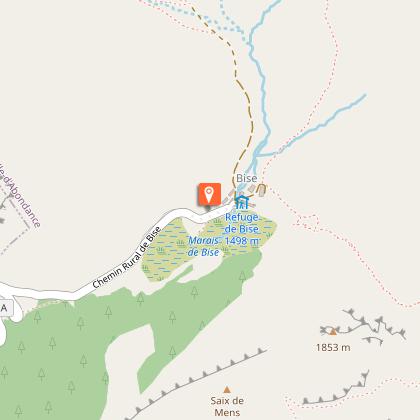
To access the "Bise site", you must go through Vacheresse: take La Revenette and Bise / Ubine. Pass on the shores of Lake Fontaine, then taken direction Bise.

Topo guides and map references

Topo guides references :
Maps and hiking guides on sale at tourist offices in the Pays d'Evian - Vallée d'Abondance area.

Map references :
- Carto-guide 65 walks and hikes in the Evian-Abondance valley area - Map of Portes du Soleil hiking trails in France and Switzerland - TOP 25 IGN N°3528 ET Morzine Massif du Chablais Les Portes du Soleil

Reception complements

Whatever your hike, remember to pack cereal bars, plenty of water, sunglasses, sunscreen, a small first-aid kit, and clothing appropriate to the season and weather forecast.

Guidebook with maps/step-by-step

0/ Departure point: Bise mountain pasture.
1/ Take the path on the right towards "Pas de la Bosse".
2/ At Pas de la Bosse, head downhill towards Chalet de la Bosse and the Chalets de Cheneau.
3/ At "Crêt Pezerin", take the path on the left towards "Col de la Vernaz".
4/ At the Col de la Vernaz, follow the path down into Switzerland. At the Coeur intersection, take the path on the left towards the Col d'Ugeon.
5/ At the Col d'Ugeon, follow "Chalets de Bise" to the starting point.

Animals

Yes. Dogs must be kept on a leash due to the presence of herds and wildlife.

Data author

Ratings and reviews

To see around
See more
Open
Close
Show
Show
Show
Show
Show
Show
Show
Show
Show
Show
Show
Caution!
We have no information on the difficulty of this circuit. You may encounter some surprises along the way. Before you go, please feel free to inquire more and take all necessary precautions. Have a good trip! 🌳🥾