Alert
Alerts
Mountain bike route - From the quays to the lakeshore

Description
Mountain bike route "From the quays to the lakeshore".
The paper version of the hiking map is available from our Information Points for €0.50.
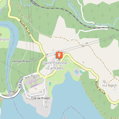
This circuit along the river starts in the heart of the picturesque village of Laroquebrou (Place du Foirail). As we leave the medieval village, we leave the River Cère to reach Saint-Étienne-Cantalès Dam lake.
A rolling, family-friendly route, this loop allows you to discover a beautiful built heritage as well as vast areas of plains and forests. You also have the chance, during this route, to walk along the famous and historic Saint-Étienne-Cantalès Dam, built between 1939 and 1945, before reaching Laroquebrou and its older part, spread out near the promontory of Montal Castle.
Technical Information
Altimetric profile
Starting point
Points of interest

Additional information
Updated by
Office de Tourisme de la Châtaigneraie Cantalienne - 04/05/2026
www.chataigneraie-cantal.com
Report a problem
Open period
All year round daily.
Subject to favorable weather.
Contact
Phone : 04 71 46 94 82
Email : info@chataigneraie-cantal.com
Website : https://chataigneraie-cantal.com
Facebook : https://www.facebook.com/otchataigneraie.cantal
Twitter : https://twitter.com/OTchataigneraie
Type of land
Ground
Hard coating (tar, cement, flooring)
Animals
Yes
