To see around
See more
Open
Close
Show
Show
Show
Show
Show
Show
Show
Show
Show
Show
Show

Oups... It would appear that Cirkwi does not have permission to use your location.

Description
Map
Points of interest
Ratings and reviews
See around

The Moulin de Bougès

Serre de Rébiouse
Vue sur la Mimente
Credit : nathalie.thomas

Description

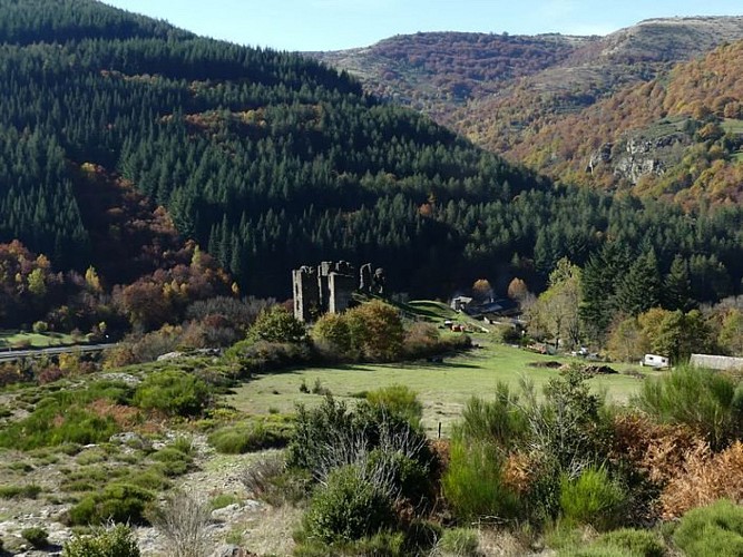
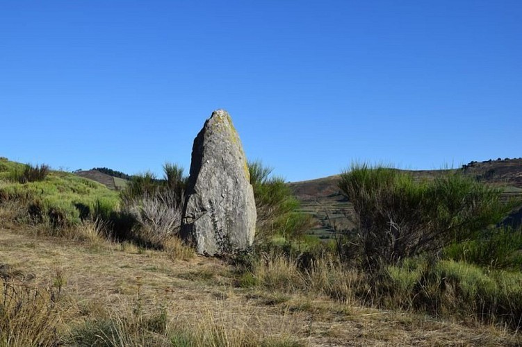
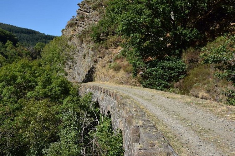
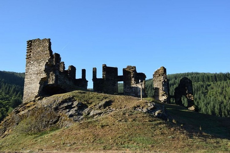
This is a journey back through time, past the ruins of the Château de Saint-Julien-d'Arpaon, the two menhirs lying nearby, and the disused railway track...

From the carpark below the temple (Protestant church), take the path uphill towards the temple, then follow the road to the top of the village. Take the path that runs alongside the Château and go uphill for about 700 m until you reach a lane. Cross it, fork left and go uphill through the heather to the highest point, which is on the western side. Follow the ridge eastwards to the Col de l'Agulharon. Then fork left. Take the lane to Bougès hamlet. As you leave the hamlet, take a downhill path, then a path on the left that runs across the slope, before returning downhill in many hairpin bends to the railway track. Turn right on this track to get back to Saint-Julien-d'Arpaon.

Technical informations

This circuit was updated on: 16/11/2022
9.3 km
3 h 45 mn
420 m

Altimetric profile

Starting point

Lat : 44.3010251Lng : 3.6638551

Points of interest

image du object

St-Julien-d'Arpaon

During the night of Saturday 22 to Sunday 23 July 1702, after Magdalene Fair, a gathering was held in a wood “near Saint-Julien”. The future leaders of the first Camisards(Protestants rebelling against Catholic rule) began recruiting volunteers to free prisoners. On 18 October 1702, after killing  Salomon Gardès, secretary to Abbot du Chaila, the Camisard troops led by Gédéon Laporte burnt down the Catholic church, vicarage and house of the notary Delapierre, The temple (Protestant church) was built in 1840.

- Parc national des Cévennes -
Consulter
image du object

The menhirs on the ground

"Two menhirs are lying on the ground just before the Col de l'Agulharon. One has three cup marks (circular hollows), one of which is the size of a bowl. Many schist slabs with cup marks have been identified in the  Cévennes. These carvings, whose meaning escapes us, have been attributed to the Neolithic, as have the menhirs. The stone with cup marks is known as “the baptism stone”. When the Edict of Nantes was revoked in 1685, making it illegal to practice Protestantism in France, many Protestants refused to convert. They waited for a pastor to visit to receive the sacraments. This stone was allegedly used to baptise children.” (P. Grime)

- Parc national des Cévennes -
Consulter
image du object

Bougès

The hamlet of Bougès currently has two year-round homes. In the summer, there are 80 to 90 inhabitants descended from families that were originally from here. In 1970, only one couple of retired farmers remained. Then another farming couple settled here: “there was broom right to the doors of the houses”. They restored the terraced meadows and fields that go up in steps behind the hamlet. Today, a farming couple produces Pélardon goats' cheese, and you may well meet their goats grazing calmly under the chestnut trees.

- Parc national des Cévennes -
Consulter
image du object

History of the path

Not so long ago, the inhabitants of Bougès still gathered chestnuts here. “We gathered them in the 60s, those were the last years. I saw my parents gathering them, they carried everything on their backs. It was one hell of a job carrying them back up that path.”More recently, the path was still in use. “That path was the postman's path. He came from Saint-Julien by Mijavols, and then he left this way, jumped across the footbridge and went up the other slope. In the old days, the postman walked 40 kilometres a day, it wasn't a restful job.”The path was used for taking grains from  Bougès down to the mill near the railway track. That made it necessary to carry out major improvements, which you can still see today. A supporting wall keeps the path's foundations in place while shaped rock or a hand-built wall protects it from rock slides. Creating many hairpin bends made it possible to reduce the slope's gradient.

- Parc national des Cévennes -
Consulter
image du object

The CFD (mountain-bike route)

Users and employees still talk of the former railway (CFD) with regret and emotion:“To go to Montpellier on Mondays, I could leave at 6 in the morning, and arrive in Montpellier at 10, and you could get back here in the evening. The train arrived at 10 o'clock in the evening. Now (with the coach), you can go down, but you have to wait for the next day to come back up. It was very useful. Nowadays, if you don't have a car, what do you do? You hitch-hike, you walk!” (P. Grime)“Two years after the train was shut down, we had the idea of putting it back on the track and turning it into a tourist train. We managed to get a railcar to start... We hadn't told anyone: apparently we didn't have the right to do it, we even risked getting a correctional sentence. Nothing happened... Except that at St-Julien-des-Points we gave a blast of this kind of horn that we had, and M., from the restaurant, came up with a litre of pastis, and two or three farmers from the area arrived too. We all cried like babies. We had the impression that the heart of the area was beating again.”  (Revue Cévennes, issue 15)

- Parc national des Cévennes -
Consulter
image du object

Château de Saint-Julien-d'Arpaon

This 13th century castle was the property of the Lords of Anduze, who owned the barony of Florac in what was then the Gévaudan. In 1618, when the Gabriac family owned it, the castle was demolished. In the 18th century, it was inherited by the Montcalm family from Rouergue province, which owned several properties in the Gévaudan. The family restored the building, but it has suffered from effects of time and is currently in ruins – though in a better state of preservation than other castles in the Gévaudan.

- Parc national des Cévennes -
Consulter

Additional information

Departure

Saint-Julien-d'Arpaon

Arrival

Saint-Julien-d'Arpaon

Ambiance

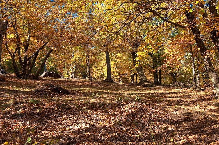
After a beautiful climb onto the ridges of the Serre de Rébiouse, hikers are rewarded with a superb view onto the heather slopes of the Bougès massif. Then the path zigzags back downhill into the chestnut grove with its many clèdes (buildings for drying chestnuts) and terraced cropland.

Access

From Florac on the N 106 towards the Col de Jalcreste

Advised parking

Below Saint-Julien-d'Arpaon temple

Advice

Make sure your equipment is appropriate for the day's weather conditions. Remember that the weather changes quickly in the mountains. Take enough water, wear good shoes and put on a hat. Please close all gates and barriers after yourself.

Is in the midst of the park

The national park is an unrestricted natural area but subjected to regulations which must be known by all visitors.

Data author

Ratings and reviews

To see around
See more
Open
Close
Show
Show
Show
Show
Show
Show
Show
Show
Show
Show
Show