Alert
Alerts
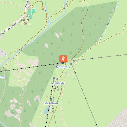
Snowshoe trail : Montfrais and its viewpoints


Description
Mountain conditions can change rapidly and may present significant hazards, such as avalanches or snow requiring specific equipment. We therefore advise you to check the trail conditions and any restrictions before setting out.
This short route can be completed in 35 minutes. It offers beautiful views of the valley and the surrounding peaks: a beautiful immersion in altitude to delight the whole family.
Even before starting the hike, remember to look out as you ride the gondola up the snowy slopes and under the cliffs: a few chamois are scratching a piece of meadow or enjoying a nap in the sun on inaccessible slopes. Only their ability to climb the steepest places allows them to evolve where others cannot go. The resort was developed in the Grandes Rousses massif, which takes its name from the colour of the rock that makes it up. You will appreciate the ochre hues of the sunset. This crystalline massif, well exposed with varied slopes, has largely allowed the development of a ski resort linked to the large domain of Alpe d'Huez. You'll pass two chalets, once alpine dwellings, named after the black grouse, a species that inhabits these areas. This animal of the hen family eats what it finds: barks, buds. Its food-poor winter life makes it fragile. Disturbing it often requires a lot of energy, which it has difficulty in meeting. Despite the fact that it is difficult to observe, its call is sometimes perceptible. Keep your eyes peeled for chamois in the rocky bars. Winter is a season of survival when food and shelter are not easy to find. If you don't see them, you can see their tracks. They are never far away. In winter they wear a black coat. In spring they lose their winter coat and change to beige, a camouflage more appropriate to the colours around them. Black is visible on the snow, but is a good colour for warming up and catching the rays. Each animal chooses a different technique and strategies for winter. Some turn white, like the mountain hare or the ermine. At the end of the walk, you'll have a view of the Col du Sabot, which once marked the boundary between Savoie and Isère. Savoie is still just behind. The Sabot pass would have been the Savoie pass because in patois, Savoie is called sabaudia. On the left is the Col du Couard whose name could come from écouardé, end of the tail, in other words, a pass at the end. Between the two you can see the Aiguillettes massif and its beautiful black cliffs with numerous folds.
Technical Information
Altimetric profile
Starting point
Additional information
Environments
Mountain location
Updated by
Office de Tourisme de Vaujany - 22/12/2025
www.vaujany.com/fr/
Report a problem
Open period
From 11/12 to 19/04 daily between 9 am and 4 pm.
Subject to favorable weather.
Type of land
Not suitable for strollers
Contact
Phone : 04 76 80 72 37
Email : info@vaujany.com
Website : https://www.vaujany.com/fr/
Reception complements
All rubbish must be brought back by the hikers. This rule applies along the trail. The forest environment must be preserved, avoid cutting branches or mutilating them.
Tips:
- Make sure that snow does not get into your shoes by using gaiters.
-While snowshoeing:
- Remember to release the heel of the snowshoe! For your information, the back of the foot is sometimes tied up when going downhill when there is a lot of snow.
- Go with poles, essential for balance.
- Don't hesitate to tap your snowshoe with the pole from time to time, it allows to remove some of the snow and thus to lighten your step.
- Foggy glasses are usually a good indicator of too much body heat or too rapid a change in body heat. If this happens, you can reduce your speed, the number of layers of clothing or simply ventilate by allowing cool air to enter under your windbreaker.
Guidebook with maps/step-by-step
From the tourist office, take the escalator down to the cable car. Go to the lift ticket office to ask for a free ticket to Montfrais. Take the cable car to the top, second section. From here you can walk up the carpet tunnel or take the carpet up. You will then follow the pedestrian markers marked on the ground with purple/mauve markers. The route is a round trip. Remember to respect the pedestrian space to avoid disturbing other trail users.
Animals
Yes
Data author
