Alert

Alerts

To see around
See more
Open
Close
Show
Show
Show
Show
Show
Show
Show
Show
Show
Show
Show

Oups... It would appear that Cirkwi does not have permission to use your location.

Presentation
Description
Map
Points of interest
Ratings and reviews
See around

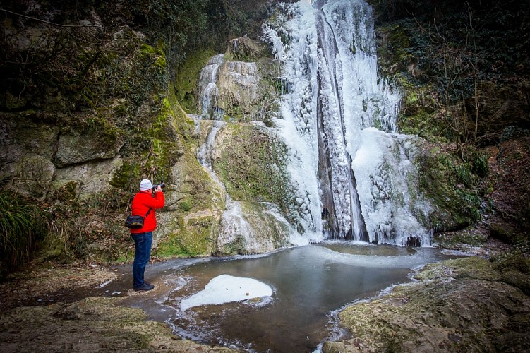
Vallon des Faulx et passerelle des vendangeurs

Description

In this haven of greenery below the center of Ceyzeriat, walkers can discover the beautiful Vallière waterfall and observe the large ferns and other plant species specific to wetlands.

In this haven of greenery below the center of Ceyzeriat, walkers can discover the beautiful Vallière waterfall and observe the large ferns and other plant species specific to wetlands. The most knowledgeable will recognize plants for food and medicinal purposes.

Technical Information

Walking
Difficulty
Easy
Duration
2h20mn
Dist.
6.6 km
Show more

Altimetric profile

Starting point

Place de la mairie , 01250   Ceyzériat
Lat : 46.179191Lng : 5.322255

Points of interest

image du object

La cascade de la Vallière, Vallon des Faulx, ENS de l'Ain

This cool, green spot is accessible via a path below the village.The Vallière, which feeds the waterfall, rises in the hamlet of La Grande Fontaine and flows into the Reyssouze after crossing a 30-metre-high rock face. The river receives water from the "Bief de Veau", which originates at the "source des 30 Chiens", under the Côte des Vignes, and from the Tréconnas stream, which originates at the Chantemerle spring. The Vallière has a large, regular flow, and its course used to include three mills spread over almost a kilometer: - The Vallière mill, downstream from the waterfall, existed as early as 1349 and was demolished in 1920. Its stones were used to build the Bouvard cookie factory in the center of Ceyzériat. - Moulin de la Roche, just above the waterfall, which came into operation in 1792. - Moulin des Billets, built in 1836 above the waterfall On the trail of Jehu's Companions... In Les Compagnons de Jéhu, published in 1857, the great writer Alexandre Dumas set an important scene of his novel in a small valley where the Vallière flows, below the church in Ceyzériat. There, in a cave, the writer sets a deadly battle between a regiment of dragoons in Bonaparte's pay and the Compagnons de Jéhu led by their leader Morgan. The Vallière River It rises in the hamlet of Grande Fontaine and flows into the Reyssouze after crossing a 30-metre-high rock barrier: the Vallière waterfall. Pont de la Roche Bridge spanning the top of the Vallière waterfall, and former fortified village gate. This site has been awarded the Espace Naturel Sensible (ENS) label by the Ain department. Real natural and landscaped jewels of the Ain department, sites with the ENS "Espaces Naturels Sensibles" label are managed in such a way as to preserve the biodiversity they host, and are designed to be open to the public (with certain exceptions due to the fragility of the environment).

Rue de la cascade 01250 Ceyzériat
- Bourg-en-Bresse destinations - Office de tourisme -
Consulter

Additional information

Environments

Riverside
Forest location
Mountain view
Village centre
Village 2 km away
Waterside
Waterfall view

Updated by

Bourg-en-Bresse Destinations - Office de tourisme - 24/11/2025
www.bourgenbressedestinations.fr
Report a problem

Open period

All year round.

Type of land

Stone
Ground
Grit

Ratings and reviews

To see around
See more
Open
Close
Show
Show
Show
Show
Show
Show
Show
Show
Show
Show
Show
Caution!
We have no information on the difficulty of this circuit. You may encounter some surprises along the way. Before you go, please feel free to inquire more and take all necessary precautions. Have a good trip! 🌳🥾