Alert
Alerts
Les bords de l'Arve - Mountain biking from Gaillard to Arthaz


Description
This walk along the Arve offers both walkers and mountain bikers a moment of relaxation and discovery of local fauna and flora as well as magnificent viewpoints of the massif des Bornes, the Haut-Giffre or even Mont-Blanc.
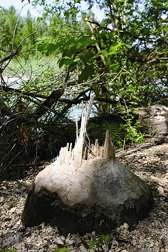
During this walk you'll come across beavers, little grebes, reed buntings and other rare birds that come to nest in these woods. With the lakes and islands on the other side of the river, you can discover a nature reserve that has been designated a biotope. Further along, after passing the bridge at Étrembières and then going past the attractive "Jardin des Iris" and the Grand Casino, you'll take the wooded path to Creuse and then cross the footbridge over the Menoge which links the municipalities of Bétraz-Monthoux and Arthaz. A few minutes later you'll enjoy a lovely view of the river.
Technical Information
Altimetric profile
Starting point
Points of interest


Additional information
Open period
All year round.
Updated by
Office de Tourisme des Monts du Genevois - 20/11/2025
www.montsdugenevois.com
Report a problem
Contact
Phone : 04 50 95 07 10
Email : ot@montsdugenevois.com
Website : https://riviere-arve.org/sm3a-syndicat-mixte-d-amenagement-de-l-arve-et-de-ses-affluents/chemin-de-l-Arve-du-Leman-au-Mont-Blanc/chemin-de-l-Arve-gaillard-arthaz
Facebook : https://www.facebook.com/MontsduGenevois/
Location complements
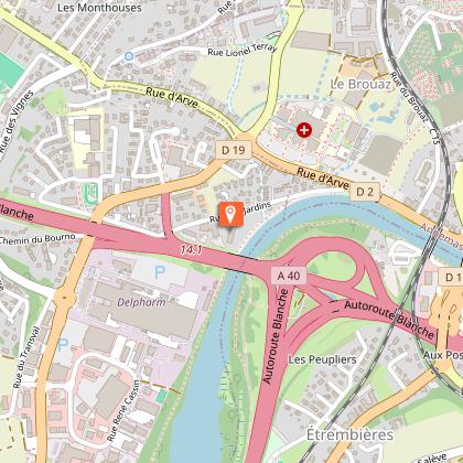
Upstream access: les Chenevriers car park, near the Bois de Vernaz in Gaillard or the Les Îles car park in Étrembières.
Downstream access: Pont Neuf car park in Arthaz-Pont-Notre-Dame.
Environments
Riverside
Close to a motorway
Town outskirts
Type of land
Ground
Grit
Tricky passages
In urban areas, you should be careful when crossing public roads open to traffic. Some short but steep sections also require good equipment.
Guidebook with maps/step-by-step
Walk up the right bank of the Arve from the Vernaz woods to rue des Jardins, at the entrance to Annemasse.
Continue along the right bank past the casino, rue de Vernand and into the wooded Creuse area as far as the Menoge confluence (footbridge).
A steep climb under the freeway brings you to the access road to the Arthaz hydroelectric dam (point 448 m on the IGN map).
2 Km After crossing the road, take a hillside path to the hamlet of Truaz.
Alternative route :
From the étangs des Iles to Etrembières, follow the left bank to the Zone bridge, which you cross to join the right-bank path.
Animals
Yes
Data author
