Alert
Alerts
Tête Nord des Fours and Refuge du Col de la Croix du Bonhomme
Description
This challenging hike takes you from the verdant alpine pastures of Plan de la Laie to the Refuge and Col de la Croix du Bonhomme via the impressive Gittes ridge. The ascent of the tête Nord de Fours offers breathtaking views of Mont Blanc.
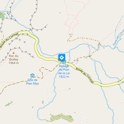
From the parking lot of the Plan de la Lai refuge, the path gradually rises towards the Col de la Sauce (2307 m). The mountain pastures give way to steeper terrain, leading to the Col de la Croix du Bonhomme via the impressive Gittes ridge. From the col, continue to the Col de la Croix du Bonhomme refuge. The final ascent takes you to the south face, the Col des Fours, before reaching the north face of Les Fours (2756 m). Exceptional panorama of Mont Blanc.
Technical Information
Altimetric profile
Starting point
Steps

Date and time
- From 01/06/2026 to 31/10/2026
- From 01/06/2027 to 31/10/2027
Additional information
Updated by
Agence alpine des territoires - 25/06/2026
www.agate-territoires.fr
Report a problem
Environments
Mountain location
Open period
From 01/06 to 31/10.
Subject to favorable snow and weather conditions.
Contact
Phone : 04 79 38 37 57
Email : info@areches-beaufort.com
Website : http://www.areches-beaufort.com
Topo guides and map references
Map references :
TOP 25 IGN - 3532 OT - Beaufortain Massif
TOP 25 IGN - 3531 OT - Megève / Col des Aravis
Type of land
Not suitable for strollers
Location complements
From Beaufort, head up towards the barrage and Cormet de Roselend. Before Cormet, park at the Plan de la Laie refuge.
Animals
Yes
Data author
