Puech espinous
Description
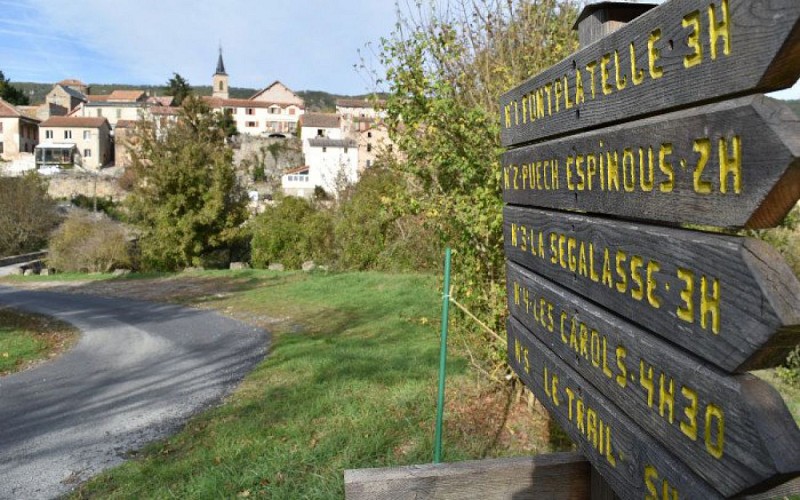
From the Cernon Valley to the Larzac plateau, between boxwood and forests, a family hike that begins with the "precious stones path”, fossil deposit and gem of geology.From the parking of La Jasse, go across the footbridge over the Cernon River, cross the road and go towards the wooden signs indicating the circuits.Take the path called “le chemin des pierres précieuses” (the gems path), then a wide stoned path, cross the road and continue straight. Pass under the railway bridge and turn right on the path of La Devèze.At the first turn, take left and follow N°2 Puech Espinous, pass by the spring gate, cross a woody area following a ditch on the left. At the end, take on the left a shaded path then pass a gate.At the end of the path, go straight. Pass next to a Canadian way by a gate, and continue on a path above the old train station. Turn right, the 50 m further turn left and enter in the Jacky’s wood (sign bois de Jacky) that you cross. Pass under the viaduct of the railway in a slope.At the bottom, at the crossroads, turn right, follow this path until you cross an uphill track, then take the path on left and pass in front of a wooden hut. You cross black bushes.Take the downhill trail on the right until you reach the next junction, then turn left at the sign “ARRIVEE” (arrival) going down a path in a meadow. Then follow to the right the path lined with boxwood from which you can see the houses of the village.
Technical informations
5.8 km
|
max. 663 m
min. 512 m
| |||
Altimetric profile
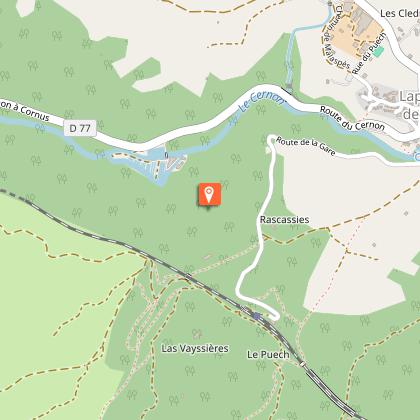
Starting point
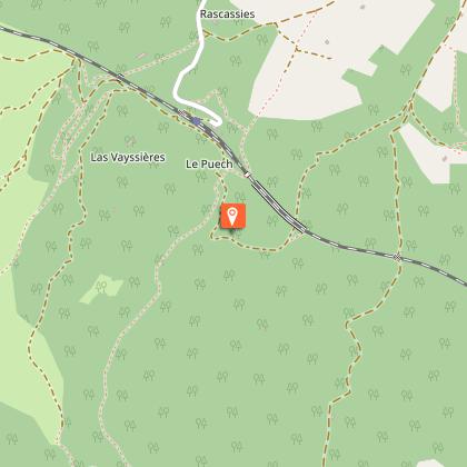
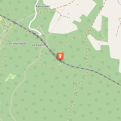
Steps
Chemins de pierres précieuses
Les marnes et les bancs calcaires le long de ce chemin sont très riches en fossiles. Ces terrains sédimentaires ont été formés il y a environ 200 millions d’années.Les marnes grises sont des terres inaptes à la culture mais qui abritent des trésors du patrimoine naturel : fossiles marins du Jurrassique (bélemnites). Les marnes sont des roches sédimentaires, constituées de calcite et d'argile dans des proportions à peu près équivalentes (35% à 65%).Sur ce chemin, on y trouve également de la pyrite (vient du grec: pierre à feu), minéral composé de disulfure de fer.
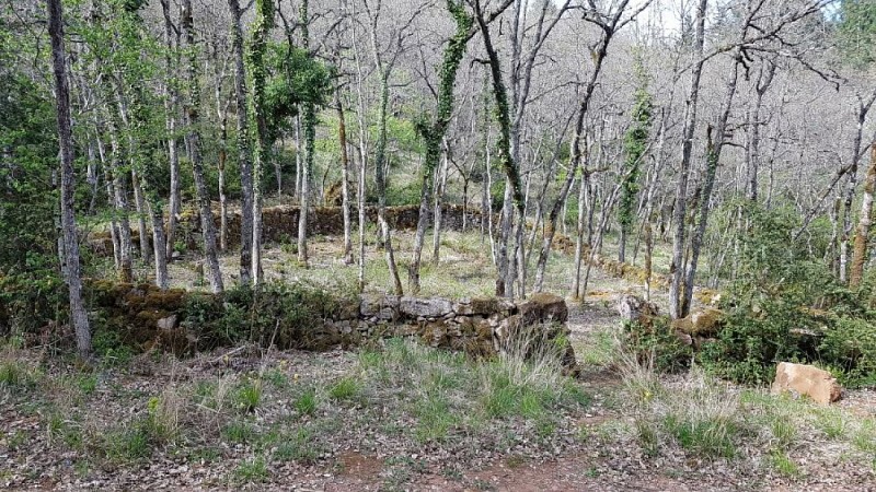
Le Castelas
De ce site ne subsistait que le lieu-dit ‘Le Castelas’, son nom même a été perdu, et aucune mention n’a été trouvée dans les textes anciens. Ce castrum à vocation militaire est installé sur un promontoire détaché des contreforts du Causse et est entouré sur trois côtés de falaises qui constituent de solides défenses naturelles. Au sud-ouest, il rejoint la pente du Causse par un isthme étroit facilement défendable. Le site permet de surveiller la vallée du Cernon, il contrôle de plus un ancien chemin montant depuis la vallée vers le Causse. Les constructeurs ont habilement exploité la topographie naturelle du site. Selon un plan classique de ces castra, ils ont installé un logis, le bâtiment rectangulaire, au point le plus haut. Il est intégré une cour défendue par une solide muraille de blocs calcaires taillés. Une seconde ligne de muraille en contrebas complétait le dispositif défensif. Les techniques de construction, dont l’absence de chaux, plaideraient pour une installation au XIe siècle, ou un peu avant. Le matériel collecté atteste d’une destruction vers la fin du XIIe siècle, suite à l’assaut ultime par une troupe de cavaliers et d’arbalétriers, sans doute au cours des conflits de frontière de l’époque entre le comté de Toulouse et la vicomté de Millau qui relève alors de la famille d’Aragon.Le matériel collecté est visible au centre Archéologique à l’Hospitalet du Larzac.Informations fournies par Lapanouse Sport Nature.
Le "pargue" de Jacky
Un "pargue" (mot d'origine occitane) est un enclos de pierre destiné à parquer les troupeaux de brebis. Les bêtes étaient enfermées aux heures les plus chaudes de la journée lorsqu’elles « tchourent » en ruminant. Le migou était récupéré pour fumer les terres à céréales, les chènevières et les jardins ou vendu dans le midi pour les vignes.
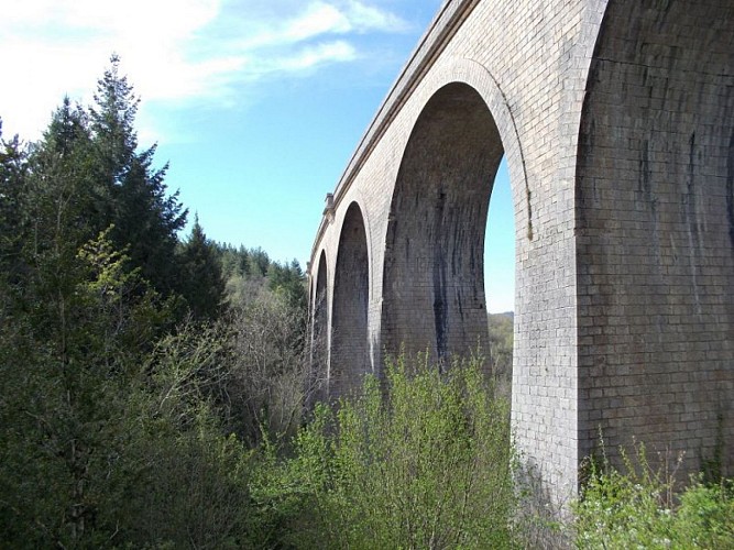
Viaduc de Lapanouse
Sur ce petit circuit, le viaduc de Lapanouse constitue un grand ouvrage avec ses 11 arches et ses 218 m de long. La voie ferrée Tournemire-Le Vigan c'est en quelques chiffres: - 60 kilomètres de long, 32 tunnels, 12 viaducs - construite à partir de 1883 et mise en service en 1896 -fermée en 1935 pour les voyageurs et 1955 pour les marchandises - enlèvement des rails en 1960 et repose en 1979 pour le projet d’extension du camp militaire du LarzacElle est actuellement exploitée en vélorail et train touristique au départ de la gare de Sainte-Eulalie de Cernon.
Points of interest
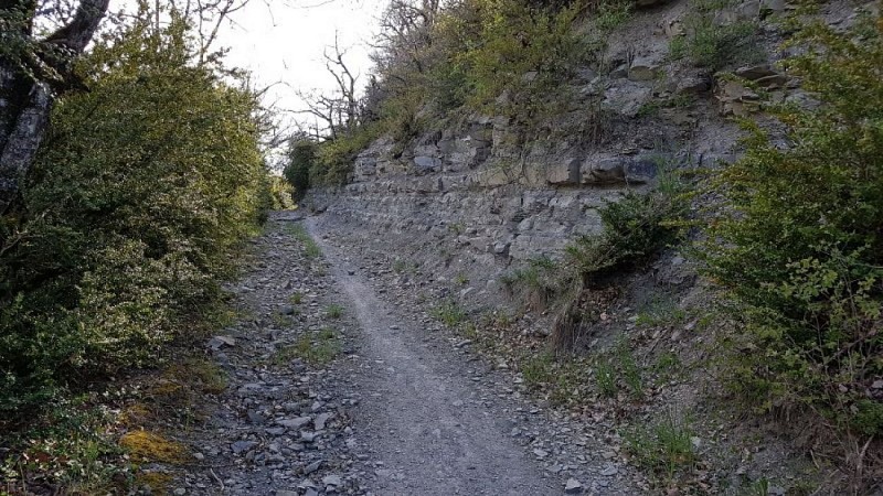
The "gems" path
The marls and limestone benches along this path are very rich in fossils. These sedimentary lands were formed about 200 million years ago.Gray marls are lands unsuitable for cultivation but contain treasures of natural heritage: Jurassic marine fossils (belemnites).Marls are sedimentary rocks, composed of calcite and clay in roughly equivalent proportions (35% to 65%).On this path, we can also find pyrite (comes from Greek: fire-stone), a mineral composed of iron disulfide.
The Jacky's "pargue"
A « pargue » (word of Occitan origin) is a stone enclosure intended to park flocks of sheep.The animals were locked during the hottest hours of the day when the ewes are grouped in the shade of the boxwood while ruminating.The dung was picked up to manure the cereals and hemp fields, the gardens or sold in the south for the vines.
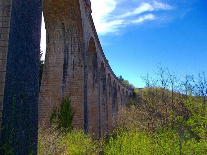
The viaduct of Lapanouse
On this small circuit, the viaduct of Lapanouse is a great work with its 11 arches and 218m long.The railway Tournemire - Le Vigan is in a few numbers :- 60 kilometers long, 32 tunnels, 12 viaducts- built since 1883 and commissioned in 1896- closed in 1935 for travelers and 1955 for goods- the removal of the rails in 1960 and the rest in 1979 for the extension project of the Larzac. It is used today by the Vélorail and tourist train of Larzac departing from the station of Sainte-Eulalie de Cernon.
Additional information
Departure
Lapanouse de Cernon
Arrival
Lapanouse de Cernon
Ambiance
Grey marls on the north side of the valley, limestone on the south side: this contrast is typical of the precious stone path, a geological site whose formation dated back 200 million years. The trail, rich in small pyriteous fossils, will delight the youngest. A fun start for an amazing hike!
Access
25km south of Millau.From Millau by the D809, the D999 direction St-Affrique and the D562E.From the A75 motorway, exit n°47 - La Cavalerie, follow the D999 direction of St-Affrique and then the D562E
Advised parking
Parking de la Jasse
Public transport
Think about carpooling and hitchhiking: Rezopouce ; Aires de covoiturage
Advice
You cross sometimes classified areas, presenting protected species. Close the gate in the grazing area, don’t near the sheep, keep the animals on a leash. Stay on marked trails, respect private property and nature. Don’t pick flowers. Bring back your waste, take care of the risk of fires. Put on good shoes and take enough water. Check the weather forecast before leaving.
Is in the midst of the park
This itinerary is located in the World Heritage zone Causses and Cévennes, mediterranean agropastoral cultural landscape.
Data author
