Alert
Alerts
Le Lec'h de Kerandiot
Description
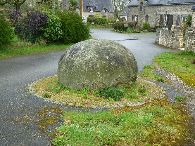
This hemispherical stone cut in granite is a sign of the Gallic settlement in our region in the 5th and 4th centuries before our era. Called a lec'h, it was once part of a group of three funerary stones indicating the presence in this area of a burial ground associated with a nearby Iron Age village. Aerial surveys have revealed enclosures which were probably contemporary with these stelae at Kerbiron, Mane Duel and Cosqueric. Burnt bones were placed in urns or small chests in the ground. More than one thousand steles have been identified in the Morbihan, including two others in the town of Calan, which are now difficult to locate. They vary in shape. Sometimes tall and elongated, they are usually low, ovoid or hemispherical like this one, and sometimes decorated with cupules.
These incinerations disappeared at the end of the 4th century before our era and some steles were broken. Others were later Christianized, engraved with a cross or moved near a religious building. Many of them became wheel chasers at the corner of buildings, were used as property markers or were built into embankments. Rosensweig, in his archaeological inventory in 1859, describes the stones of Kerandiot: “three rounded lec'h, one that went into the construction of a wall; another overturned next to it; the third, remarkable for its size, 2 meters in diameter and 1.50 m high, at the foot of a very old oak tree.” He adds: “It is one of the extremely rare cases where we found these kinds of stones elsewhere than in the vicinity of a chapel.”
In the 1980s, the archaeologist Daniel Tanguy reported the three stelae of Kerandiot, grouped on this small square on the site of an ancient chapel dedicated to St. Conneth. Was it Saint Connec, a former disciple of Saint Caradec, who gave his name to a town in the Côtes d'Armor department? It's hard to say. The remaining stele, 1.40 metres in diameter and 1 metre high, is decorated with two cupules on its top. One of them has been hollowed out.
