Alert
Alerts
Description
Map
Ratings and reviews
See around
Panorama sur le sentier des douaniers de la baie d'Audierne.
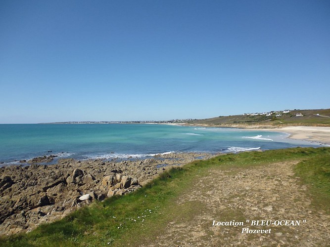
Credit
: patrick Kerouedan
Description
Vue panoramique magnifique à 180° sur la baie d'Audierne qui s'étend de la pointe de Penmarc'h au Sud à la pointe du Raz au Nord.
Le GR 34.
Créé en 1791 et utilisé par les douaniers qui patrouillaient le long de la côte, ce chemin de 1800 km est aujourd'hui un des plus emblématiques sentiers de Grande Randonnée français.
Le GR 34 ou « sentier des Douaniers » offre constamment d’imprenables vues sur la mer.
Aujourd’hui, il longe le littoral breton, du Mont-Saint-Michel au barrage d’Arzal dans le Morbihan.
Technical Information
Lat, Lng
47.9869-4.47551
Coordinates copied
Uncertain state
Point of Interest updated on 13/12/2016
This point of interest hasn't been updated recently, which could compromise the reliability of this information. We recommend that you inquire and take all necessary precautions. If you're the author, please verify your information.
Altimetric profile
IGN cards

0419ET - AUDIERNE POINTE DU RAZ ILE DE SEIN
Editor : IGN
Collection : TOP 25 ET SÉRIE BLEUE
Scale : 1:25 000
13.90€

VEL07 - LE FINISTERE A VELO
Editor : IGN
Collection : DECOUVERTE A VELO
Scale : 1:110 000
9.10€

89029 - LE SENTIER DES DOUANIERS BRETAGNE SUD GR34®
Editor : IGN
Collection : DECOUVERTE DES CHEMINS
Scale : 1:100 000
9.10€

NR06 BRETAGNE
Editor : IGN
Collection : CARTES RÉGIONALES IGN
Scale : 1:250 000
6.80€

801 FRANCE NORD OUEST
Editor : IGN
Collection : CARTES NATIONALES IGN
Scale : 1:320 000
6.10€

EUROPE
Editor : IGN
Collection : DÉCOUVERTE DES PAYS DU MONDE IGN
Scale : 1:2 500 000
7.00€
Data author

proposed by
gitebleuocean
Ratings and reviews
To see around