La Dibona

Description
La Dibona Is a huge rock of granite pointing up into the pure Oisans mountain air that attracts mountaineers from all over the world. Climbing on the sound rock of this elegant 300 m pyramidal monolith is varied, subtle and always hugely pleasurable.
Climbing the 14 or 15 pitches of these granite slabs is a highlight in the life of any climber.
The south face, which is the most attractive and popular, is a fine climb. A combination of routes leads to the summit: the direct south face Voie Madier, the normal south face Voie Boell, the Berthet variant and the Stofer variant.
The Voie Madier is now 50 years old and still going strong, having been partially re-equipped (bolts and 2 points per pitch). The top of the crack has been damaged and the 5C has become a quite tricky 6A. A large friend is required.
The descent is in 2 or 3 abseils down the Voie Angelo Dibona.
First Ascension: South face by A. and J. Boell, A. le Ray in 1935.
Map and guide: TOP 25 3436 ET Meije Pelvoux
"Oisans nouveau, Oisans sauvage" Livre Ouest, Jean-Michel Cambon
Difficulty: D (voie Berthet-Boell), TD (voie Madier)
Time required: 6 hours
CULTURE: Portrait of Angelo Dibona
Angelo Dibona (1879-1956) was one of the finest guides of his generation. He opened major routes on the Meije and in the Dolomites. An exceptional climber and pioneer of modern climbing, he particularly enjoyed tackling extensive faces. In his prime between 1908 and 1914, he could be seen climbing all over the French Alps, from the Dauphiné to Mont Blanc. On 27 June 1913, in winter conditions, he calmly climbed the Pain de Sucre du Soreiller, a needle considered unclimbable, which, after years of debate, became known as the Dibona. At the age of 37, he opened the normal route, before setting off for other Alpine adventures, leaving his name to this iconic Oisans needle.
Technical Information
Altimetric profile
Date and time
- From 01/06/2024 to 30/09/2024
Additional information
Reception complements
Mountaineering is the ascent of mountains that requires special equipment to climb over rock, ice or cliffs.
Rating: Two aspects are considered in the rating of mountaineering, the technical difficulty and the altitude and duration. The + or - refines the rating in each category.
F / Easy
PD / Not Very Difficult
AD / Quite Difficult
D / Difficult
TD / Very Difficult
ED / Extremely Difficult
ABO / Abominably Difficult
Equipment: Harness, mountain boots, helmet, crampons, ice axe, 100m abseiling rope, belays and friends, quickdraws, ice screws, self-locking device, headlamp, altimeter watch. Equipment can be rented in many sports shops.
Contact the mountain professionals in Oisans. Full list on www.montagne-oisans.com/montagne-alpes-sejours-20.html
Location complements
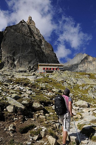
From Bourg d'Oisans, take the RD 1091 towards Briançon and then turn right onto the D530 to "Saint-Christophe - La Bérarde". Park on the left in Les Etages (after Saint Christophe) and follow the path up to the Refuge du Soreiller (1100 m height gain / around 3 hours).
Contact
Phone : 04 76 80 50 01
Email : info-berarde@oisans.com
Website : www.oisans.com/a-voir-a-faire/activites-sportives/alpinisme/
Open period
From 01/06 to 30/09 : open daily.
Updated by
Oisans Tourisme - 26/12/2023
www.oisans.com
Report a problem
Price(s)
Free of charge
Data author
