Alert
Alerts
Description
Map
Ratings and reviews
See around
Retour au parking
Credit
: Pau Pyrénées Tourisme / LA
Description
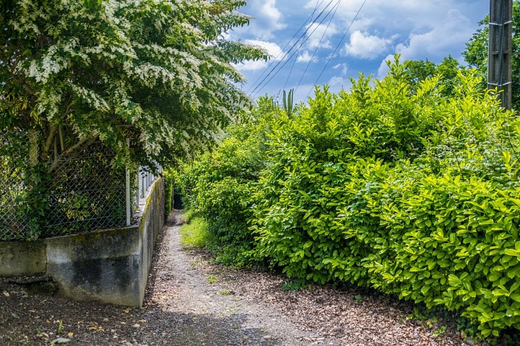
Quand la rue fait un coude, tourner à gauche et emprunter le chemin qui descend entre le mur de clôture et la haie laurier cerise. Au niveau de la route, tourner à droite et continuer à descendre. Au panneau STOP, traverser au passage piéton et tourner à gauche en direction du pont. Passer devant l’église et au rond-point continuer tout droit. Après l’école tourner à droite sur le chemin de Labielle. Traverser la voie ferrée puis 100m après tourner à gauche et poursuivre sur le chemin de Labielle. Tourner à droite en direction du lac pour retrouver le parking de départ.
Technical Information
Lat, Lng
43.28318-0.32767
Coordinates copied
Uncertain state
Point of Interest updated on 01/01/1970
This point of interest hasn't been updated recently, which could compromise the reliability of this information. We recommend that you inquire and take all necessary precautions. If you're the author, please verify your information.
Altimetric profile
IGN cards
1545ET - PAU
Editor : IGN
Collection : TOP 25 ET SÉRIE BLEUE
Scale : 1:25 000
13.90€

159 PAU AUCH MONT-DE-MARSAN GASCOGNE
Editor : IGN
Collection : TOP 100
Scale : 1:100 000
8.40€

TOP100D64 - PYRÉNÉES-ATLANTIQUES PAU BAYONNE BIARRITZ PAYS BASQUE BÉARN
Editor : IGN
Collection : TOP 100
Scale : 1:100 000
8.40€

TOP100D65 - HAUTES-PYRÉNÉES TARBES LOURDES GAVARNIE NÉOUVIELLE PARC NATIONAL DES PYRÉNÉES
Editor : IGN
Collection : TOP 100
Scale : 1:100 000
8.40€

89021 - ST-JACQUES-DE-COMPOSTELLE GR®65-2 DE MOISSAC A RONCEVAUX
Editor : IGN
Collection : DECOUVERTE DES CHEMINS
Scale : 1:100 000
9.10€

D64 PYRÉNÉES-ATLANTIQUES
Editor : IGN
Collection : CARTES DÉPARTEMENTALES IGN
Scale : 1:150 000
5.90€
D31-65 HAUTE-GARONNE HAUTES-PYRÉNÉES
Editor : IGN
Collection : CARTES DÉPARTEMENTALES IGN
Scale : 1:150 000
5.90€

D32-82 GERS TARN-ET-GARONNE
Editor : IGN
Collection : CARTES DÉPARTEMENTALES IGN
Scale : 1:150 000
5.90€

NR10 NOUVELLE-AQUITAINE RECTO /VERSO LIMOUSIN POITOU
Editor : IGN
Collection : CARTES RÉGIONALES IGN
Scale : 1:250 000
6.80€

NR11 NOUVELLE-AQUITAINE RECTO/VERSO BASSIN AQUITAIN
Editor : IGN
Collection : CARTES RÉGIONALES IGN
Scale : 1:250 000
6.80€

EUROPE
Editor : IGN
Collection : DÉCOUVERTE DES PAYS DU MONDE IGN
Scale : 1:2 500 000
7.00€
Data author

Ratings and reviews
To see around