Alert
Alerts
Landscape of war
Description
Landscape of war
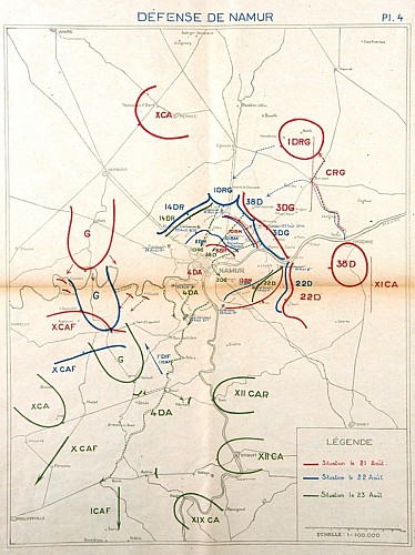
At the time of the siege of Namur, the Germans had learned lessons from the stinging defeat of the first wave of assault launched two weeks previously against the fortified position of Liège, and which aimed to take the different forts by force. At Namur, the Germans immediately formed a siege army composed of heavy artillery and concentrated their fire, from 21st August at around 10 am, on a section of the Namur forts, those of the 4th sector (Marchovelette and Cognelée).
The Namur forts were subjected to the fire of the heavier artillery that the Germans had at their disposal, namely the Austrian 305 mm mortars and the famous 420 mm M-type mortars (nicknamed 'Big Berthas'), which in addition to their unequalled fire power, fired out of range of the fort cannons.
The ratio of power was completely unequal, the Namur forts' resistance hopeless. After several hours they surrendered, but not without having fought: the fort garrisons only gave up after the complete destruction of the forts' weaponry, and when the air became unbreathable because of the thick smoke produced by gunpowder fire. The wounded soldiers were taken to Champion Sœurs de la Providence hospital in particular
before being sent as prisoners to Germany.
Only fort Malonne garrison surrendered without fighting and without the fort having been bombed.
Technical Information
Altimetric profile
IGN cards


Data author
