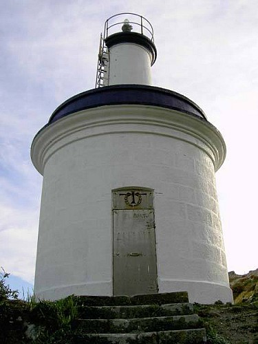
Alert

Alerts

To see around
See more
Open
Close
Show
Show
Show
Show
Show
Show
Show
Show
Show
Show
Show

Oups... It would appear that Cirkwi does not have permission to use your location.

Description
Map
Ratings and reviews
See around

FARO DA PORTA

FARO DA PORTA

Description


The area of faro da Porta, built in 1918, takes its name from the canal which is between the lighthouse island and the southern one and it´s also called O Freu da Porta. If we have a look from Punta Carnaval we can get a general idea of what is happening in the sea, in these rich valuable underwater ecosystems where there is a great biodiversity and constituted some of the reasons why the islands were declared Maritime-Terrestrial National Park of the Atlantic Islands in Galicia. The 86% of the surface of the park is maritime (the only one in Spain together with the one in Cabrera) that´s why the marine environment is so important.

So we will be able to explore the diverse seafloors, the meaning of “coastal zoning”, the meaning of “ardora”, the influence of tides or the presence of sea mammals.

Technical Information

Lat, Lng
42.212323473673-8.9126730307494
Coordinates copied
Uncertain state
Point of Interest updated on 18/08/2016
This point of interest hasn't been updated recently, which could compromise the reliability of this information. We recommend that you inquire and take all necessary precautions. If you're the author, please verify your information.

Altimetric profile

Ratings and reviews

To see around
See more
Open
Close
Show
Show
Show
Show
Show
Show
Show
Show
Show
Show
Show
Caution!
We have no information on the difficulty of this circuit. You may encounter some surprises along the way. Before you go, please feel free to inquire more and take all necessary precautions. Have a good trip! 🌳🥾