Alert
Alerts
PLACE DE L’ANGE
Description
Today’s configuration of the square is the result of a secular evolution.
Its main delineations were fixed from the 13th C. and have barely changed since.
The layout of the rues de Fer and de l’Ange were drawn over the tracks of an important axis into the town from the North which dates back to the Romans. These paths were fully established by the Middle Ages.
A market located on this axis has been mentioned since the 13th C. and seems to have been placed around a central “hall” which belonged to the Count of Namur. During the 13th C., the Count transferred the hall to the inside of the fortifications. Where the Place de l’Ange is today became a block of houses which were knocked down in 1935 when the square took on the appearance which it keeps today.
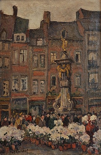
In 1740, a water pump mounted by the statue of an angel had already been installed. This is undoubtedly where the square derived its name from. It was replaced in 1791 by a new water pump erected by François- Joseph Denis, a sculptor. It has not been in use since 1924 after the lions’ muzzles were removed as well as the metallic arm which allowed the pump to work.
Classified since 1936 due to its historical, archaeological and artistic value, the water pump was renovated in 2011.
Tableau d’Albert Dandoy « la Toussaint, marché de l’Ange »…see TH.Oger
Technical Information
Altimetric profile
Data author
