Alert
Alerts
Description
Map
Ratings and reviews
See around
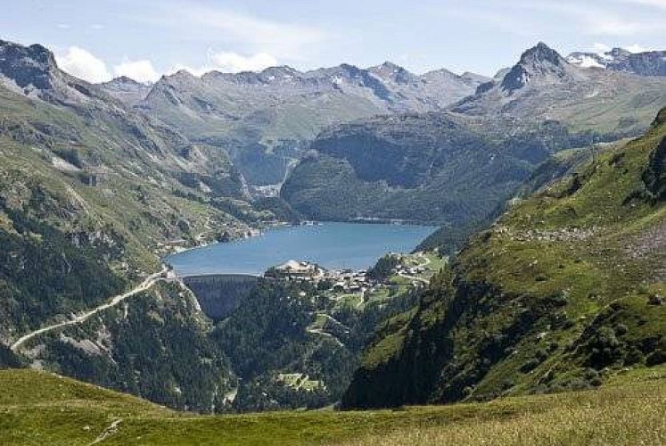
The Chevril dam
Credit
: PNV - BALAIS Christian
Description
From the cross looking south-east, you can see the Chevril hydrœlectric dam, established on the Isère river below the ski resort of Tignes, which is the only access road. At the time of its construction in 1952, it was the highest arch dam in Europe at 181 metres high. Its impounding caused the engulfment of the old village of Tignes, populated back then by 387 inhabitants. The expropriated families were relocated to the new village of Boisses (village located at the foot of the dam).
Technical Information
Lat, Lng
45.5240146.9015491
Coordinates copied
Point of Interest updated on 27/03/2024
Altimetric profile
IGN cards

3532ETR - LES ARCS LA PLAGNE RESISTANTE PARC NATIONAL DE LA VANOISE
Editor : IGN
Collection : TOP 25 RÉSISTANTE
Scale : 1:25 000
17.20€

3532ET - LES ARCS LA PLAGNE PARC NATIONAL DE LA VANOISE
Editor : IGN
Collection : TOP 25 ET SÉRIE BLEUE
Scale : 1:25 000
13.90€

TOP75004 - BEAUFORTAIN MASSIF DU MONT BLANC
Editor : IGN
Collection : TOP 75
Scale : 1:75 000
9.80€

TOP75003 - MASSIF DE LA VANOISE
Editor : IGN
Collection : TOP 75
Scale : 1:75 000
9.80€

TOP100D73 - SAVOIE CHAMBÉRY ALBERTVILLE PARC NATIONAL DE LA VANOISE PNR DU MASSIF DES BAUGES
Editor : IGN
Collection : TOP 100
Scale : 1:100 000
8.40€

202 JURA ALPES DU NORD
Editor : IGN
Collection : TOP 200
Scale : 1:200 000
6.80€

D38 ISÈRE
Editor : IGN
Collection : CARTES DÉPARTEMENTALES IGN
Scale : 1:150 000
5.90€

NR15 AUVERGNE-RHÔNE-ALPES RECTO/VERSO MASSIF ALPIN
Editor : IGN
Collection : CARTES RÉGIONALES IGN
Scale : 1:250 000
6.80€

NR14 AUVERGNE-RHÔNE-ALPES RECTO/VERSO MASSIF CENTRAL
Editor : IGN
Collection : CARTES RÉGIONALES IGN
Scale : 1:250 000
6.80€

EUROPE
Editor : IGN
Collection : DÉCOUVERTE DES PAYS DU MONDE IGN
Scale : 1:2 500 000
7.00€
Data author

proposed by
Parc national de la Vanoise
Ratings and reviews
To see around