Tours
Activities
Places of interest
Where to eat
Where to sleep
Relaxation and adventure at Johannes Brakkee, Cromary
Are you the owner?Welcome to the page dedicated to Johannes Brakkee, your perfect getaway to explore the charming surroundings of Cromary, Haute-Saône, in Franche-Comté. Nature enthusiasts will be delighted by the numerous outdoor activities available in the region. Enjoy the close proximity to the Chaux Forest, the second largest state forest in France, ideal for peaceful hikes or bike rides.
History buffs will n...See more
History buffs will n...See more
Walking around JOHANNES BRAKKEE
See more suggestionsDiscover the trails of JOHANNES BRAKKEE.
See more suggestions


What to do in JOHANNES BRAKKEE
See more suggestionsExperience unique moments with the bookable activities in JOHANNES BRAKKEE.
See more suggestions


IGN cards
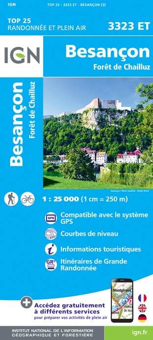
3323ET - BESANCON FORÊT DE CHAILLUZ
Editor : IGN
Collection : TOP 25 ET SÉRIE BLEUE
Scale : 1:25 000
13.90€

3322SB - RIOZ GY
Editor : IGN
Collection : TOP 25 ET SÉRIE BLEUE
Scale : 1:25 000
13.90€

130 VESOUL LANGRES VALLÉE DE LA SAÔNE
Editor : IGN
Collection : TOP 100
Scale : 1:100 000
8.40€

TOP100D70 - HAUTE-SAÔNE VESOUL LURE VALLÉE DE LA SAÔNE
Editor : IGN
Collection : TOP 100
Scale : 1:100 000
8.40€

201 ALSACE MASSIF DES VOSGES
Editor : IGN
Collection : TOP 200
Scale : 1:200 000
6.80€

D25-39 DOUBS JURA
Editor : IGN
Collection : CARTES DÉPARTEMENTALES IGN
Scale : 1:150 000
5.90€

D70-88-90 HAUTE-SAÔNE VOSGES TERRITOIRE DE BELFORT
Editor : IGN
Collection : CARTES DÉPARTEMENTALES IGN
Scale : 1:150 000
5.90€

NR09 BOURGOGNE FRANCHE-COMTÉ
Editor : IGN
Collection : CARTES RÉGIONALES IGN
Scale : 1:250 000
6.80€

EUROPE
Editor : IGN
Collection : DÉCOUVERTE DES PAYS DU MONDE IGN
Scale : 1:2 500 000
7.00€

ALLEMAGNE
Editor : IGN
Collection : DÉCOUVERTE DES PAYS DU MONDE IGN
Scale : 1:800 000
7.00€
What to visit in JOHANNES BRAKKEE
See more suggestionsSavor the local cuisine of JOHANNES BRAKKEE.
See more suggestions


Where to eat in JOHANNES BRAKKEE
See more suggestionsEstablishments in JOHANNES BRAKKEE offer dishes for all tastes.
See more suggestions


Where to sleep in JOHANNES BRAKKEE
See more suggestionsFind lodging to suit your needs in JOHANNES BRAKKEE.
See more suggestions


