Alert
Alerts
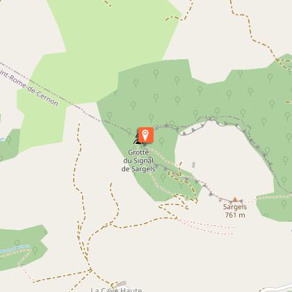
The Sargels residual mound


Description
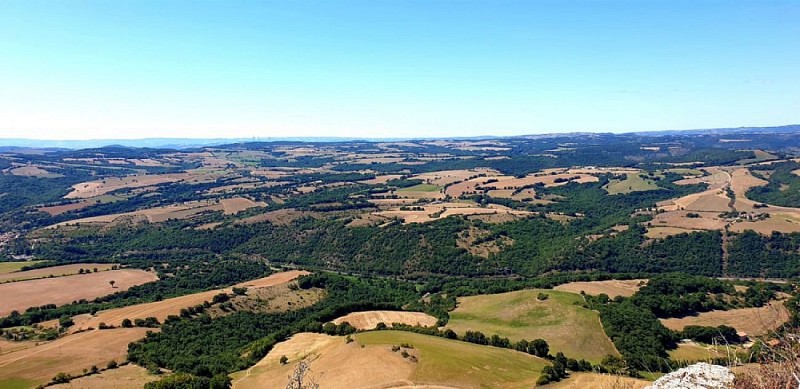
According to legend, the mound is referred to as “the tomb of the giant”. The Sargel mound which culminates at 761 m above sea level, offers breathtaking views over Lévézou, the causse of the western Larzac and the Merdelou peak.On the Southern part of the car park take the rue de la passade up to the end of the street, then turn left to walk across the D999 road and carry on along the Avenue de la Cavalerie where you cross the bridge up to the other end and turn left before the railway line on a road that leads to the stadium (signpost).600 m further on, Just before this bridge, leave the road and take a trail along the railway.After 500 m, pass under a second bridge to cross the railway which you overlook now alongside your way. Carry on northwards until you catch sight of a small house (formerly a crossing-keeper's house) located below left.From there, turn sharp right and take the path which ascends the ravine. Leave the path to the right and carry straight on. After 700 m, follow the hair pin bend and continue along an old path lined with dry stone walls which leads to the Cave Basse.This path takes you above the swimming pool and turn left between the buildings. Walk along the trail into a “boussière” (a narrow passage defined by two rows of box trees) and join the path coming from the Cave Haute. Take left and just after right. Now, follow the wide trail ascending towards the mound. The slope becomes steeper and follows a series of hair pin bends. After the 6th bend you arrive on the plateau, where you will see a ruined sheepfold on the right. Walk to the left of the fence, and after a wide bend you will reach the calvary where you can enjoy the beautiful landscape of the surrounding plateaus: the Lévézou, Roquesquatre and the Merdélou.To return, retrace your way back to the Cave Basse (4). When you reach the swimming pool, take the left path which descends towards a dilapidated old barn: The Batisse.The path links up with a small tarmacked road. Follow this road up to the railway. Walk under the bridge that was left aside on the way there (2). Retrace your way back to the car park.
Technical Information
Altimetric profile
Starting point
Points of interest

Additional information
Public transport
Travel by bus or train: lio.laregion.fr/carpooling : BlaBlaCar, Rézo Pouce, Mobicoop, Idvroom, LaRoueVerte, Roulez malin
Advice
Travel by bus or train: www.mobimipy.fr/carpooling : BlaBlaCar, Rézo Pouce, Covoiturage-libre, Idvroom, LaRoueVerte, Roulez malin
Is in the midst of the park
This itinerary is located in the World Heritage zone Causses and Cévennes, mediterranean agropastoral cultural landscape.
Advised parking
Car park opposite the village hall
Access
Situated 15 km from Saint-Affrique and 18 km from Millau via the D992 and the D 999 roads.
Arrival
Car park opposite the Village Hall
Ambiance
Starting from the village of Saint-Rome-de-Cernon, escalate the Sargel mound and discover a Caussenard built heritage such as a hamlet and a Jasse. This site is an ancient Neolithic human settlement.From the summit, a superb view over the Grands Causses including the Roquesquatre rock on the southern side can be enjoyed.
Departure
Car park opposite the Village Hall
Data author
