Alert
Alerts
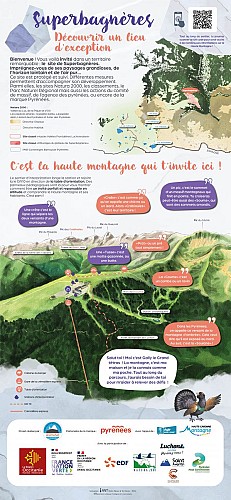
PN - SENTIER D'INTERPRÉTATION DE SUPERBAGNÈRES


Description
The interpretive trail starts at the exit of the Crémaillère Express.
Accessible to all, it skirts around the resort and joins the orientation table and the GR10 trail. Information panels are provided to show you how to be a perfect and responsible visitor at altitude. This is a very open trail, offering impressive views and panoramas.
This new trail is an opportunity to discover or rediscover the lexicon of the mountains, from its fauna and flora to the history of Luchon-Superbagnères. It helps you understand and name everything around you. A real guide for little mountaineers in the great outdoors, on a protected site with magnificent landscapes, marked out in five stages.
1. Welcome
2. The Luchon Valley
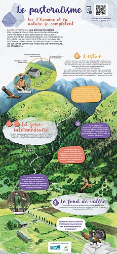
3. Around us
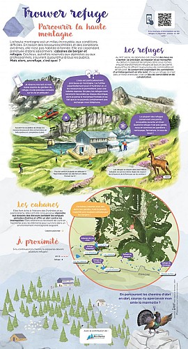
4. Hiking in the high mountain
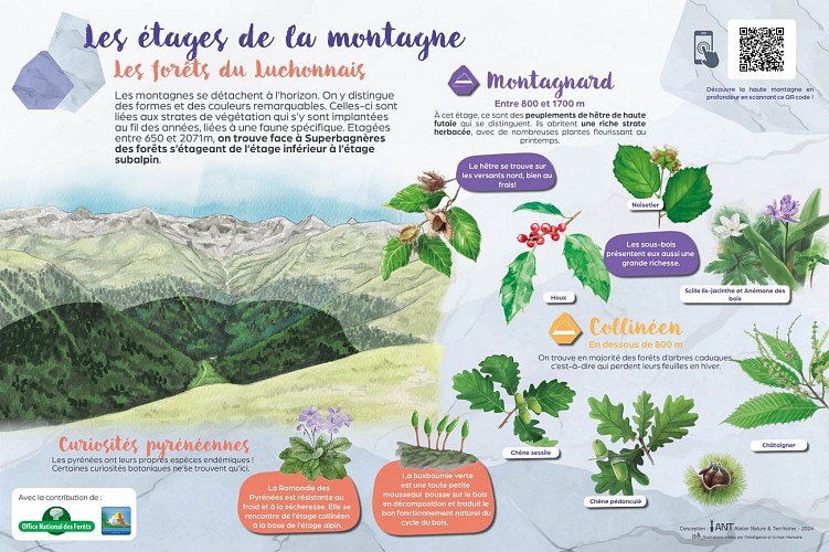
5. The different levels of the mountain.
Technical Information
Altimetric profile
Starting point
Points of interest

Additional information
Detailed stages
1 - Luchon-Superbagnères website: Discover an exceptional place! - You will learn the meaning of words used to describe the high mountains (ridges, peaks, tusse, etc.).
You will learn how animals in the mountains adapt to survive in extreme conditions.
Some tips are always useful for hiking in the high mountains.
2 - The Luchon Valley: Mountains in harmony with the art of building! - You will follow the different stages of transformation of a Pyrenean valley from the Ice Age to the 20th century.
You will discover how it is possible to reach the summits while respecting the site.
There are many people in the high mountains, both professionals and visitors.
3 - Around us: The diversity of the pastoral environment! - You will become an expert on the ancestral activity of pastoralism.
Do you know the black grouse, an emblematic species of the Pyrenean forests?
4 - Hiking in the high mountains: Explore the high mountains and find refuge! - Do you know the difference between a refuge and a hut?
Water is a precious resource, and the use of hydraulic energy is an ancient tradition in the Pyrenees.
Get to know the brown bear, a discreet and solitary animal.
5 - Mountain layers: a magical landscape thanks to layers of vegetation! - Read the landscape to discover the different layers of the mountain between 650 m and 2,071 m above sea level.
Elevation gain
100 (Low)
Start and end town
SAINT-AVENTIN
Contact
Tel : 05 61 79 21 21
Website : www.pyrenees31.com
Email : info@pyrenees31.com
Data producer
Contact : HAUTE-GARONNE TOURISME / OFFICE DE TOURISME PYRÉNÉES 31
Phone : 05 61 79 21 21
This information comes from the Haute-Garonne Departmental Tourism Network and is synchronized as part of the partnership between Cirkwi and Haute-Garonne Tourisme.
Data author
