Alert
Alerts
MTB circuit 29 red - Côte de Chambod / Val de Buenc - Espace Revermont Base FFvélo

Description
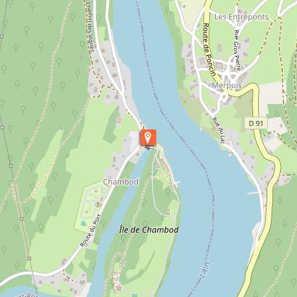
Starting from Ile Chambod, on the banks of the Ain Gorge, a climb up the Chambod slope to reach the Charinaz wood, the Buenc valley and then the Merloz slope.
(being marked out spring 2025).
Departure possible from Hautecourt
Technical Information
Altimetric profile
Starting point
Points of interest


Additional information
Distinctions
Listed PDIPR
Label VTT - FFCT
Updated by
Bourg-en-Bresse Destinations - Office de tourisme - 01/06/2026
www.bourgenbressedestinations.fr
Report a problem
Environments
Lakeside or by stretch of water
Riverside
Overview on river
Mountain view
Forest location
Less than 10 minutes from a bus stop on foot
Beach within 300 m
Waterside
Lake view
In the country
Isolated
Sensitive Natural Area
River -5 km away
Lake -5km away
Close to a public transportation
Open period
All year round daily.
Contact
Phone : 04 74 22 49 40
Email : accueil@bourgenbressedestinations.fr
Website : https://www.bourgenbressedestinations.fr
Topo guides and map references
Topo guides references :
Base VTT FF Vélo - Espace Revermont / Grand Bourg Agglomération
Type of land
Ground
Hard coating (tar, cement, flooring)
Grit
Location complements
Parking
Free parking at the Chambod leisure centre
Departure sign on site
Access :
Route du port from Hautecourt or Allement
Cize-Bolozon station / Ceyzeriat station / Simandre station / Villereversure station
By public transport
Access by public transport
Find out more about how to get to the port from www.grandbourg.fr/42-transports-mobilites.htm
Tricky passages
Safety instructions
No technical passages to report. Please respect the mountain biker's charter.
Please remain cautious on roads and paths, especially at crossings and junctions.
Please respect other road users and keep in mind our natural reflexes.
The Revermont routes may cross pastures, so be sure to close the gates and respect the peace and quiet of the herds.
Respect each other's activities: in the mountains, there's room for everyone!
www.pasto-kezako.fr/
Certain areas may be affected by protected sites: Natura 2000, ENS, classified sites... let's respect nature, stay on the trails, be discreet in our attitudes and tracks...
The routes include hiking, trail and horse-riding circuits, as well as certain hunting areas. Please respect other users of the land.
Report a problem
Damaged markings, safety incident, conflict of use or illegal dumping?
Locate and report the situation via the national SURICATE system, from the application or online: sentinelles.sportsdenature.fr/
Equip yourself
We strongly recommend that you bring a bottle of water, a helmet, a cell phone, a route map and a repair kit.
Colorful clothing is also recommended, so as to be clearly visible to other trail users.
Animals
No
