Alert
Alerts
From the red stones of Panossas to the green panoramas of Isle-Crémieu
1 alert on this circuit
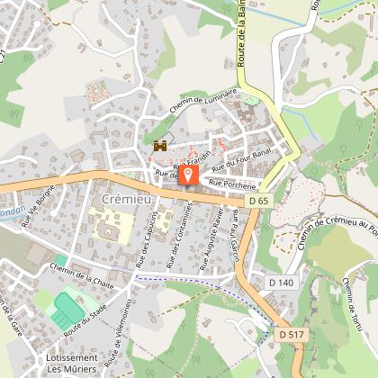
CRÉMIEU, CITÉ MÉDIÉVALE:
Alerte visiteurs
Difficulté de stationnement lors de grandes manifestations.
Description
In the south-west of the Balcons du Dauphiné, between hills and ponds, Panossas stands out for its beautiful red hues, a phenomenon that can be explained by the rich iron content of the limestone, which is found in the various architectural features.
The village then gives way to a variety of landscapes, from undergrowth to panoramic views over the Isle-Crémieu, as you make your way along this hilly walking route.
Technical Information
Altimetric profile
Starting point
Points of interest


Additional information
Contact
Phone : 04 74 90 45 13
Email : tourisme@balconsdudauphine.fr
Website : https://www.balconsdudauphine-tourisme.com/
Facebook : https://www.facebook.com/profile.php?id=61556501098829
Open period
All year round daily.
Subject to favorable weather.
Environments
In the country
Panoramic view
Type of land
Stone
Ground
Grit
Not suitable for strollers
Updated by
Office du Tourisme Les Balcons du Dauphiné - 24/11/2025
www.balconsdudauphine-tourisme.com/
Report a problem
Topo guides and map references
Topo guides references :
A walking guide entitled ‘From the red stones of Panossas to the green panoramas of Isle-Crémieu’ (FFR - Balcons du Dauphiné Collection) is on sale at the Tourist Information Offices in Crémieu, Morestel, Les Avenières-Veyrins-Thuellin and Saint-Chef.
Tips
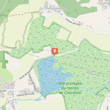
Interpretation trail at the Charamel sensitive natural area (to be discovered in addition to this walk) :
Labelled a Sensitive Natural Area since 2004, the Charamel peat bog
Charamel peat bog is a major wetland in the Isère department.
A 10.5 km interpretation trail takes you through this ecosystem
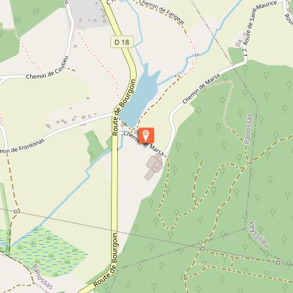
Marsa pond and its mill. This
rich reservoir of biodiversity is home to 300 species of vascular plants
vascular plants (which help to transport water, among other things) and 139 species of
of birds.
A detailed information booklet is available free of charge from
tourist information offices.
Reception complements
Hiking boots recommended.
History, culture and heritage
The fortified house of Antouillet :
Our region, situated on the border between Savoie and Dauphiné, had many fortified houses. Antouillet is a fine example. This house once played a military role, helping to defend the area. Its watchtowers (circular towers attached to the wall) can still be seen (circular towers attached to the wall).
The Tilleul de Serre :
This tree has an impressive girth of over 4.20 metres.
However, there is no evidence to suggest that it is listed as one of the Sully lime trees. Dating back to 1650, the lime tree was intended to provide a shady place to gather in the villages. It stands in the centre of the hamlet, which is made up of traditional farmhouses with rusty tones due to the iron-bearing limestone of this part of the Isle of Man.
of this part of the Isle-Crémieu.
Guidebook with maps/step-by-step
1- From the car park, turn left and follow the D18. The route follows the GR® markings (white-red).
At the Jubilee Cross, continue straight ahead, leaving the return road on your right. Take the Chemin des Fuziers.
After passing the town hall, turn left at the wash-house. Go straight on along the Chemin de Coutieu, passing the Charmoncel spring.
Leave the dry grassland path. Continue along the road, then turn left down the Chemin d'Antouillet as far as the "Antouillet" sign.
2-Leave the GR® and continue straight downhill to the Chemin de Frontonas, then right onto the Chemin de Serre as far as the Sully lime tree.
Follow the wide track to the right that leads to the "Salette" signpost.
3-Fork right 3 towards Chozeau.
Follow the road to the left. At the crossroads, follow the road to the left for 600 m, then turn right onto the dirt track. Keep to the right.
At the "Mont Morel" post, take the path on the right towards the Quincieu cross.
Reach the track and keep right as far as the pond. Follow the road past the Quincieu farm to the Quincieu cross.
From here, go right along the pond, turn left and 125 m further on take the path that climbs steeply through the woods.
4- At the top, emerge into the field, following the edge to the left. At the end of the field follow the
left as far as the village.
5- Return to the car park on the left. Once you reach the Jubilee Cross, follow the same route as the outward journey.
Animals
Yes. Pets allowed on lead only.
Data author
