Alert
Alerts
Type of practice
Walking
Very easy
3h20mn
Presentation
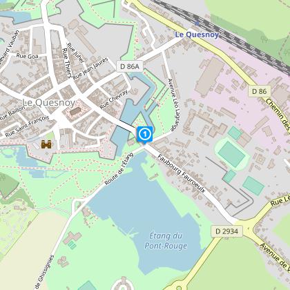
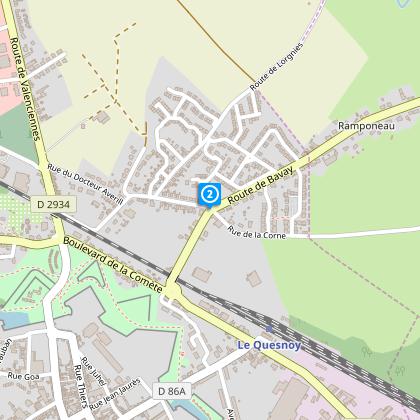
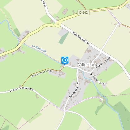
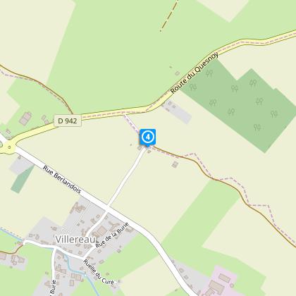
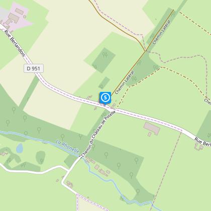
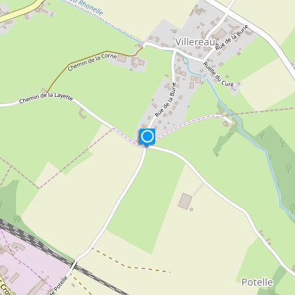
Map
Steps
Points of interest
Cirkwi brief's
Ratings and reviews
See around
Potelle Circuit


Credit : Nord Tourisme
The Cirkwi brief
Discover Scenic Potelle: A Bucolic Trail Adventure
Embark on a journey through the serene landscapes of Le Quesnoy, courtesy of Nord Tourisme, and immerse yourself in the bucolic charm of the Circuit de Potelle. This trail, devoid of any strenuous difficulties, weaves through picturesque country hedges and characteristic streets. It beckons travelers with a promise of tranquility amidst the fortified splendors of Vauban. The path offers an escape to nature, where the melodies of the Rhonelle river accompany your every step. Prepare to be seduced by the blend of historical grace and natural beauty on this leisurely walk.
Key Details: Seize Your Adventure
Spanning just over 10 kilometers with a modest elevation gain between 89 to 88 meters, the Circuit de Potelle offers an accessible trek with minimal physical demands. The altitude fluctuates between a manageable 93 to 136 meters, ensuring a relatively even terrain throughout. Trailblazers are guided by the yellow markers, making navigation straightforward. Despite the route's gentle nature, the crossing of RD 942 and 951 roads requires a bit of vigilance. However, these technical details contribute to a well-rounded and safe walking experience for all.
Seasonal Tips & Safety Insights
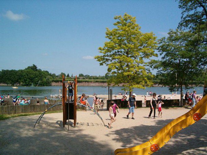
As the local guide, my top advice for enjoying the Circuit de Potelle safely across the seasons includes footwear selection; sturdy shoes are crucial, especially after rain when paths may become muddy. Summer visitors should enjoy supervised swimming at La P'tite Plage. In autumn and spring, the trail's beauty shines, but remember to stay cautious on wet days. Winter brings its own charm, though fewer amenities are available, and the paths can be slippery. Always heed warning signs, particularly when navigating the fortifications and road crossings, to ensure a memorable and secure journey.
Le Quesnoy: Heart of Heritage
Le Quesnoy boasts a rich tapestry of history and cultural significance within the Hauts-de-France region. Renowned for its well-preserved fortifications designed by the illustrious Vauban, the town invites a step back into a strategic past where walls speak of sieges and resilience. This area, nestled in the verdant swathes of Northern France, encapsulates the spirit of the country's fortitude and artistry. The Circuit de Potelle not only showcases nature's splendor but also traverses through a locality steeped in centuries of historic allure.
Climate Guide: Best Times Await
Le Quesnoy's Enchanting Climate Unveiled
The region surrounding Le Quesnoy enjoys a temperate climate, marked by mild summers and cool winters - ideal for year-round exploration. Rainfall is fairly distributed, ensuring lush, verdant landscapes. For the most pleasant walking conditions, spring (April to June) and early autumn (September to October) are recommended, offering a delightful array of colors, comfortable temperatures, and fewer rainy days. These periods highlight the natural and architectural beauty of the Circuit de Potelle, making your visit truly unforgettable.
Embark on a journey through the serene landscapes of Le Quesnoy, courtesy of Nord Tourisme, and immerse yourself in the bucolic charm of the Circuit de Potelle. This trail, devoid of any strenuous difficulties, weaves through picturesque country hedges and characteristic streets. It beckons travelers with a promise of tranquility amidst the fortified splendors of Vauban. The path offers an escape to nature, where the melodies of the Rhonelle river accompany your every step. Prepare to be seduced by the blend of historical grace and natural beauty on this leisurely walk.
Key Details: Seize Your Adventure
Spanning just over 10 kilometers with a modest elevation gain between 89 to 88 meters, the Circuit de Potelle offers an accessible trek with minimal physical demands. The altitude fluctuates between a manageable 93 to 136 meters, ensuring a relatively even terrain throughout. Trailblazers are guided by the yellow markers, making navigation straightforward. Despite the route's gentle nature, the crossing of RD 942 and 951 roads requires a bit of vigilance. However, these technical details contribute to a well-rounded and safe walking experience for all.
Seasonal Tips & Safety Insights
As the local guide, my top advice for enjoying the Circuit de Potelle safely across the seasons includes footwear selection; sturdy shoes are crucial, especially after rain when paths may become muddy. Summer visitors should enjoy supervised swimming at La P'tite Plage. In autumn and spring, the trail's beauty shines, but remember to stay cautious on wet days. Winter brings its own charm, though fewer amenities are available, and the paths can be slippery. Always heed warning signs, particularly when navigating the fortifications and road crossings, to ensure a memorable and secure journey.
Le Quesnoy: Heart of Heritage
Le Quesnoy boasts a rich tapestry of history and cultural significance within the Hauts-de-France region. Renowned for its well-preserved fortifications designed by the illustrious Vauban, the town invites a step back into a strategic past where walls speak of sieges and resilience. This area, nestled in the verdant swathes of Northern France, encapsulates the spirit of the country's fortitude and artistry. The Circuit de Potelle not only showcases nature's splendor but also traverses through a locality steeped in centuries of historic allure.
Climate Guide: Best Times Await
Le Quesnoy's Enchanting Climate Unveiled
The region surrounding Le Quesnoy enjoys a temperate climate, marked by mild summers and cool winters - ideal for year-round exploration. Rainfall is fairly distributed, ensuring lush, verdant landscapes. For the most pleasant walking conditions, spring (April to June) and early autumn (September to October) are recommended, offering a delightful array of colors, comfortable temperatures, and fewer rainy days. These periods highlight the natural and architectural beauty of the Circuit de Potelle, making your visit truly unforgettable.
Automatically generated.
Technical Information
Walking
Difficulty
Very easy
Duration
3h20mn
Dist.
10 km
Type of practice
Walking
Very easy
3h20mn
Show more
Altimetric profile
Starting point
100
parking de l’Etang du Pont Rouge
,
59530
LE QUESNOY
Lat : 50.2456894939Lng : 3.64261992143
Steps
Data author

Ratings and reviews
To see around