Alert
Alerts
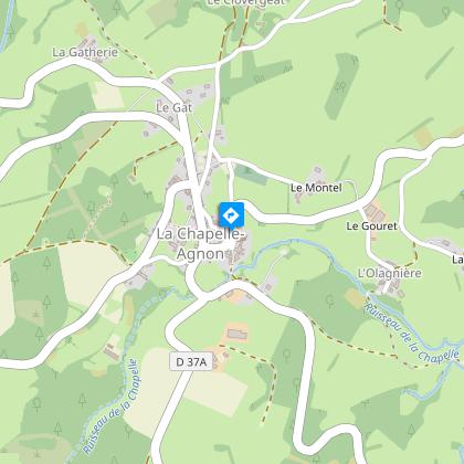
La Chapelle-Agnon
Description
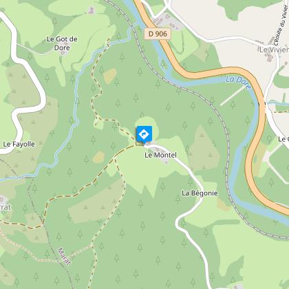
A hike through landscapes of orchards and woods, typical of the Livradois region. Nature is wild, with views over the Dore valley, the Haut-Forez and the Sardie valley, as well as heritage sites such as the Vierge cross, the Montel well and the church of St-Blaise.
Technical Information
Altimetric profile
Starting point
Steps
Additional information
Tips
View of the Dore valley, Haut-Forez and Sardie valley, and heritage sites such as the Vierge cross, Montel well and St-Blaise church.
Updated by
Conseil départemental du Puy-de-Dôme - 02/06/2026
www.puydedome-tourisme.com/
Report a problem
Environments
In the country
Forest location
Presence of livestock and guard dogs
Distinctions
Listed PDIPR
Open period
From 01/01 to 31/12 daily.
Subject to favorable weather.
Location complements
From the village of Cunlhat, take the D65 for 9 km towards Chapelle-Agnon.
Contact
Phone : 07 85 96 70 89
Email : sylviane.echalier-tronchon@vacances-livradois-forez.fr
Website : https://www.auvergne-livradois-forez.com
Reception complements
For your own safety, always take a bottle of water, a hat, warm clothing and footwear suitable for walking.
Depending on weather conditions, certain itineraries are not recommended in bad weather (fog) or are not practicable, or even forbidden, during the winter season.
Some sites are fragile, so stay on the marked trails. Avoid picking wild flowers and disturbing wildlife. Pick up your garbage.
Animals are not allowed on some routes.
Guidebook with maps/step-by-step
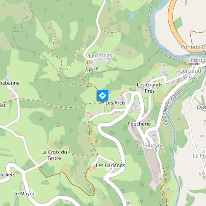
1/ From the Chapelle-Agnon church. Go down the D267 and take the first left. At the cemetery, go straight ahead, then right at a stone cross. At the crossroads, turn right (view of the Forez mountains) and at the crow's feet, right again towards La Collange. Before this hamlet, take the left-hand tarmac track and continue straight ahead. At the crossroads, head downhill along a footpath until you come to a crossroads with a detached house.
2/ Turn left and head north, leaving several paths to your left and right. Staying on the ledge, cross the hamlets of Combas and Mouhet. After Mouhet, take the road on the left to reach the hamlet of Paton, where you bend left (view of the Dore valley and Forez mountains).
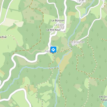
3/ Leaving Le Montel, take the left-hand path up to the edge of the forest. Continue until you reach the road above Le Varrat. Turn left, ignoring the forest tracks. At Le Crouhet, take a path down into the valley in front of the house on your right. Cross the ruisseau du Sardie to go up under Farnouze.
4/ At the crossroads, turn left and cross a stream, then go up and continue on the right-hand path. After the large ruined building, turn left. At Farges, go alongside the hamlet and take a path down to the stream on the left. Cross the stream and climb up to the D37 (view of the Monts du Forez), which you take for 100 m. At the crow's-foot, turn left to return to the cemetery and church.
Proposed and managed by the Conseil départemental du Puy-de-Dôme - PDIPR.
Animals
Yes. Dogs must be kept on a leash due to the presence of herds.
Data author
