Alert

Alerts

To see around
See more
Open
Close
Show
Show
Show
Show
Show
Show
Show
Show
Show
Show
Show

Oups... It would appear that Cirkwi does not have permission to use your location.

Presentation
Description
Map
Steps
Points of interest
Ratings and reviews
See around

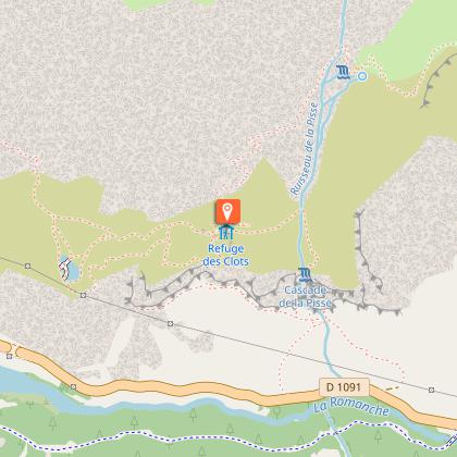
The Petrifying Fountain - Hike from Les Aymes (Mizoën)

1 alert on this circuit

NATURA 2000 : LA FONTAINE PÉTRIFIANTE:

Alerte visiteurs

Attention : ce site est inventorié Natura 2000 et fait l’objet de nombreuses mesures pour préserver sa biodiversité. La circulation des véhicules motorisés et des VTT est interdite, ainsi que les feux, les dépôt déchets, le camping-bivouac et la circulation piétonne en dehors des sentiers.

IGN cards

3335ETR - LE BOURG-D'OISANS L'ALPE D'HUEZ RESISTANTE GRANDES ROUSSES SEPT LAUX
Editor : IGN
Collection : TOP 25 RÉSISTANTE
Scale : 1:25 000
17.20€
3336ETR - LES DEUX ALPES RESISTANTE OLAN MUZELLE PARC NATIONAL DES ÉCRINS
Editor : IGN
Collection : TOP 25 RÉSISTANTE
Scale : 1:25 000
17.20€
3335ET - LE BOURG-D'OISANS L'ALPE D'HUEZ GRANDES ROUSSES SEPT LAUX
Editor : IGN
Collection : TOP 25 ET SÉRIE BLEUE
Scale : 1:25 000
13.90€
3336ET - LES DEUX ALPES OLAN MUZELLE PARC NATIONAL DES ÉCRINS
Editor : IGN
Collection : TOP 25 ET SÉRIE BLEUE
Scale : 1:25 000
13.90€
TOP75006 - MASSIF DES ECRINS OISANS CHAMPSAUR
Editor : IGN
Collection : TOP 75
Scale : 1:75 000
9.80€
TOP100D38 - ISÈRE GRENOBLE VIENNE PARC NATIONAL DES ÉCRINS PARC NATUREL RÉGIONAL DU VERCORS
Editor : IGN
Collection : TOP 100
Scale : 1:100 000
8.40€
TOP100D73 - SAVOIE CHAMBÉRY ALBERTVILLE PARC NATIONAL DE LA VANOISE PNR DU MASSIF DES BAUGES
Editor : IGN
Collection : TOP 100
Scale : 1:100 000
8.40€
202 JURA ALPES DU NORD
Editor : IGN
Collection : TOP 200
Scale : 1:200 000
6.80€
D04-05 ALPES-DE-HAUTE-PROVENCE HAUTES-ALPES
Editor : IGN
Collection : CARTES DÉPARTEMENTALES IGN
Scale : 1:150 000
5.90€
D38 ISÈRE
Editor : IGN
Collection : CARTES DÉPARTEMENTALES IGN
Scale : 1:150 000
5.90€
NR14 AUVERGNE-RHÔNE-ALPES RECTO/VERSO MASSIF CENTRAL
Editor : IGN
Collection : CARTES RÉGIONALES IGN
Scale : 1:250 000
6.80€
NR16 PROVENCE-ALPES-CÔTE D'AZUR
Editor : IGN
Collection : CARTES RÉGIONALES IGN
Scale : 1:250 000
6.80€
NR15 AUVERGNE-RHÔNE-ALPES RECTO/VERSO MASSIF ALPIN
Editor : IGN
Collection : CARTES RÉGIONALES IGN
Scale : 1:250 000
6.80€
EUROPE
Editor : IGN
Collection : DÉCOUVERTE DES PAYS DU MONDE IGN
Scale : 1:2 500 000
7.00€

Description

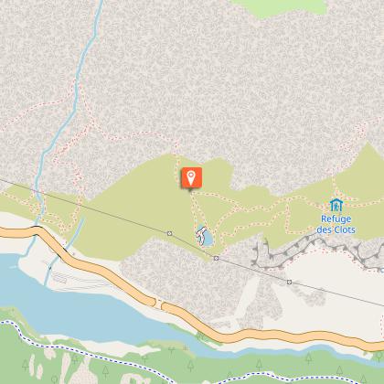
Discover the Fontaine Pétrifiante waterfall, a veritable refuge for biodiversity and home to rare and threatened ecosystems. On the balcony path leading up to the waterfall, you'll enjoy a panoramic view of Lac du Chambon and the Uissans peaks!

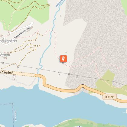
From the Aymes parking lot, follow the signs for Les Clots or the GR 54 C (red and white). You'll then begin your hike along a track passing through a shady area.
Shortly afterwards, the trail narrows and the trees become rarer. The path is on a balcony. The route includes a few passages where the path is narrower: cables are available to help you along.
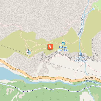
For the first 2 km, the climb is gentle and gradual. From the 2nd kilometer onwards, the climb steepens but remains gradual for 1.23 km, until you reach the hamlet of Les Clots. Before the latter, you'll pass close to Lac Lovitel, where you can make a short detour.
Between Lac Lovitel and the refuge des Clots, you can make another detour via the orientation table at the top of the rocky promontory beside the lake.
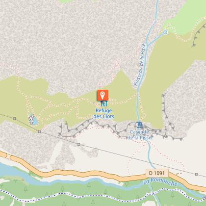
The hamlet of Les Clots is located on a flat area, where you can enjoy the peaceful atmosphere and views of the Petrifying Fountain and the Meije.
From the hamlet to the summit of the Cascade, continue along the GR 54 C route. The path is steeper and rockier.
The cascade is a protected area: do not leave the path.
Just before you reach the top, you'll have to cross some small streams - be careful, the ground can be slippery!
Once you've reached the top of the waterfall, you can retrace your steps to reach the parking lot. Once at the top of the waterfall, you can continue on the GR towards the Plateau d'Emparis.
On your way back, take a break at the refuge in the hamlet of Les Clots, which offers meals, to make the most of this idyllic setting.

Technical Information

Walking
Difficulty
Easy
Duration
4h
Dist.
9 km
Show more

Altimetric profile

Starting point

38142   Mizoën
Lat : 45.049289Lng : 6.15616

Points of interest

1 alert
image du object

Natura 2000 : la Fontaine Pétrifiante

Située à 1 750 mètres, dans la commune de Mizoën, la Fontaine Pétrifiante est une cascade naturelle fascinante. Visible depuis le GR54C, cette résurgence compte parmi les plus belles de France et doit son origine à la nature géologique du site.La fontaine pétrifiante, qu’est-ce que c’est ? Depuis 190 000 millions d’années, la formation de cette résurgence est la conséquence d’une faille séparant deux ensembles de roches aux caractéristiques physiques très différentes. Voici comment ! Les eaux qui jaillissent de cette cascade proviennent du Plateau d'Emparis, situé à 2 372 mètres d’altitude. C’est donc plus haut que les eaux s'infiltrent à travers des couches de roches sédimentaires perméables, riches en calcaire soluble, et se chargent en bicarbonate de calcium. Sur leur chemin, elles rencontrent un nouveau type de roche. Il s’agit d’un sous-sol hercynien, composé de roches cristallines imperméables. Les eaux ainsi bloquées sont contraintes de suivre l'axe de la faille pour resurgir à la surface. À ce moment-là, l'eau entre en contact avec l’air produisant ainsi une réaction chimique. Le résultat crée une roche sédimentaire tendre, appelée tuf calcaire. Ce tuf, de couleur jaunâtre tirant sur l’orange, s'accumule en couches successives au fil du temps. Souvent, cette roche capture des fragments de végétaux. Lorsque ceux-ci se décomposent, ils laissent derrière eux des cavités qui forment des tubes creux et des alvéoles à l'aspect caverneux caractéristiques du tuf. Ainsi, l'empreinte de ces végétaux peut être conservée pendant des millions d'années. La Fontaine Pétrifiante n’est donc pas qu’une simple cascade, mais aussi une tufière. Pour information : autrefois, le tuf calcaire était employé comme matériel de construction pour les maisons des villages aux alentours. Facilement sculptable due à sa porosité, sa légèreté et sa résistance, il était surtout utilisé pour les pièces d’ornement (encadrement de fenêtres, manteaux de portes, etc.). Les habitants de la Fontaine Pétrifiante : Cette tufière est un habitat pour de nombreuses espèces animales et végétales rares, remarquables et parfois menacées (bien que la plupart d’entre elles ne soient pas exclusives aux tufières) Parmi elles, la grenouille rousse, observée jusqu'à 2 500 mètres d'altitude, utilise les petites retenues d'eau pour pondre ses œufs. Partiellement protégée en France, sa capture ou son abattage est interdit. La flore la plus étonnante se trouve à proximité immédiate de la tufière, au niveau de la résurgence. En effet, cette zone humide, appelée tourbière, abrite une formation d’herbacées denses et peu élevées, dominées par la laîche de Davall. Plusieurs espèces de bryophytes (mousses) y prospèrent également, présentant un intérêt biologique particulier : elles sont les seules plantes à avoir conservé la majorité des caractères génétiques des premiers végétaux colonisateurs de la Terre. Ces bryophytes colonisent divers endroits, tels que les rochers nus ou les fissures rocheuses. Leurs débris contribuent à la formation d'humus, ralentissant l'évaporation et aidant à maintenir l'humidité du sol. Les tufières sont des écosystèmes rares en montagne et constituent des habitats prioritaires pour l'Europe. C'est pourquoi cette tufière est protégée au titre d'un arrêté préfectoral de protection de biotope (APPB) et intégrée au réseau européen Natura 2000. Ces milieux sont fragiles, ne sortez pas du sentier (même s’il est tentant de prendre des photos) !

- Oisans Tourisme -
Consulter

Additional information

Tips

A large part of the hike is on a balcony path. Progress can be difficult for those prone to vertigo. Also, take care if you wish to do this hike in the presence of children.

Sustainable tourism

The Fontaine Pétrifiante is a unique resurgence in the Oisans. It's not just a waterfall, but also a tufa. Tufa beds are rare mountain ecosystems and priority habitats for Europe. That's why this tufa bed is protected by a prefectoral biotope protection order (APPB) and included in the European Natura 2000 network.
These environments are fragile, so don't leave the path (even if it's tempting to take photos)!

Updated by

Oisans Tourisme - 03/12/2025
www.bike-oisans.com
Report a problem

Environments

Mountain view
Panoramic view

Open period

From 01/05 to 31/10 daily.

Subject to favorable snow and weather conditions.

Location complements

The hike starts from the Aymes parking lot in Mizoën. The road between the village of Mizoën and the hamlet of Les Aymes is winding and high, and crossings can be tricky (over 2.2 km). There's a great view of the Chambon dam. Once you reach Les Aymes, at the end of the hamlet, a narrow, unpaved track leads to the parking lot.
You can park in the hamlet and walk to the parking lot.

Topo guides and map references

Topo guides references :
OBP (Oisans au Bout des Pieds) n°3 card On sale at Oisans Tourisme tourist offices

Map references :
Map IGN Top25 3335ET - LE BOURG-D'OISANS L'ALPE D'HUEZ

Type of land

Stone
Ground

Reception complements

Remember to bring water, good shoes, a hat/cap and sun protection.

Tricky passages

The route is on a balcony path. It can be difficult for those prone to vertigo.

Animals

Yes

Data author

Image Oisans Tourisme
proposed by Oisans Tourisme
1 bis rue Humbert 38520 Le Bourg d'Oisans France

Ratings and reviews

To see around
See more
Open
Close
Show
Show
Show
Show
Show
Show
Show
Show
Show
Show
Show
Caution!
We have no information on the difficulty of this circuit. You may encounter some surprises along the way. Before you go, please feel free to inquire more and take all necessary precautions. Have a good trip! 🌳🥾