Alert
Alerts
Itinerant hiking : on the roof of the Jura mountains


IGN cards


Description
A route between ridges and forests, culminating in the Colomby de Gex. Discover the breathtaking scenery of the Haut-Jura, with its vast valleys, rugged terrain and mountain atmosphere, with a restful stop-off in the village of Mijoux.
From the wild Valserine valley to the balcony of Lake Geneva, this route plunges you into the authenticity of the Haut-Jura. Crossing the Hautes Combes, you will be struck by the raw beauty of the wide open spaces, the silence of the deep forests and the open horizon of the plateaux. The path gradually rises, revealing exceptional panoramic views of Mont Blanc and the entire Alpine chain. It's an immersion in nature, a land of traditions and high altitude landscapes.
Good to know - Protected area
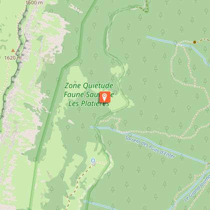
Part of the route passes through the Haute Chaîne du Jura National Nature Reserve, which is subject to special regulations:
Dogs are not allowed, even on a lead.
Bivouacs in tents are prohibited.
Please respect these rules to preserve the richness of this exceptional environment.
Technical Information
Altimetric profile
Starting point
Points of interest


Date and time
- From 01/04/2025 to 30/11/2035
- From 01/04/2026 to 30/11/2036
Additional information
Contact
Phone : 04 50 28 09 16
Email : contact@paysdegex-tourisme.com
Website : https://www.paysdegex-montsjura.com
Open period
Closed temporarily.
Environments
Mountain location
In a nature reserve
Type of land
Rock
Stone
Ground
Hard coating (tar, cement, flooring)
Grit
Not suitable for strollers
Topo guides and map references
Map references :
3328OT - CRÊT DE LA NEIGE
3327ET - MOREZ LES ROUSSES
Updated by
Office de Tourisme du Pays de Gex - 03/12/2025
www.paysdegex-montsjura.com
Report a problem
Reception complements
▶ This route crosses the Haute Chaîne du Jura National Nature Reserve. Please respect the regulations.
The rules include the following:
Dogs are strictly forbidden, even on a lead.
Plant picking and mineral collecting are also prohibited.
▶ Before setting off :
Check the general and local weather forecast, and make sure there's no precipitation.
Find out about the approach route, the height of the itinerary, the time it will take to complete the climb, and any possible escapes (IGN map, GPS, topo-guide, etc.).
Evaluate possible risks by asking mountain professionals, mountain huts and gîtes.
Inform someone close to you of your objective, and contact them again in the event of any changes: departure and return times, number of participants with telephone numbers for each, vehicle(s), parking, etc.
Avoid setting off alone, and use equipment that is suitable for the activity, adjusted and in good condition: headlamp, complete first-aid kit, survival blanket, etc.
In the event of a problem, call 112 (European emergency number).
▶ The Patou or guard dog: what attitude should you adopt?
When out hiking, it's not uncommon to come across flocks of sheep or goats guarded by guard dogs known as patous. These dogs, formidable against predators such as wolves, bears and lynxes, can frighten hikers with their barking.
The patou protects flocks in total autonomy. Its main role is to deter intruders and alert the shepherd. Raised among the ewes from an early age, he learns to protect them at all times, often in groups.
▶ To avoid problems with a patou:
Identify grazing areas before setting off.
Keep your distance and go around flocks if possible.
In the event of an encounter, stay calm, turn back slowly or stop to let the dog sniff you out.
Don't try to pet or feed the animals, avoid sudden movements, don't run, and avoid taking photos.
▶ For runners:
Do not run when approaching a herd.
Take off your headphones to hear the dog's barking.
By adopting these behaviors, you'll be able to cohabit serenely with guard dogs on your hikes.
Guidebook with maps/step-by-step
▶ Day 1: Lélex → Mijoux (via Haut-Jura)
⏱ Approximately 4 h - 14.4 km - D+ 471 m / D- 372 m
From Lélex, follow the yellow markings towards Moulin Pierre Louis, then continue towards La Pralouse, Croaby and Sous Cariche. Then join the GR (red and white) to cross Le Manon and Lajoux before reaching Mijoux. A fine day's approach through valleys and forests.
▶ Day 2: Mijoux → Lélex (via the crests of the Haute Chaîne du Jura)
⏱ Approximately 5h30 to 6 h30 - 16,4 km - D+ 1048 m / D- 948 m
From Mijoux, take the red and white GR and climb towards the Col de la Faucille. Climb the Grand Mont Rond, then reach Colomby de Gex, before continuing on to the Col de Crozet. Pass Refuge de la Loge, then Ratou before descending to Lélex. A more alpine stage, with a balcony overlooking the Alps.
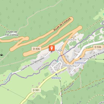
Overnight in Mijoux
Take a break in the mountain village of Mijoux. A number of accommodation options are available:
▶ Les Berlicants, in a peaceful natural setting
▶ La Michaille, for a warm and authentic atmosphere
▶ Le Gîte communal de la Valserine, practical and friendly, right in the heart of the village
Animals
No. dogs strictly forbidden.
Data author
