Alert
Alerts
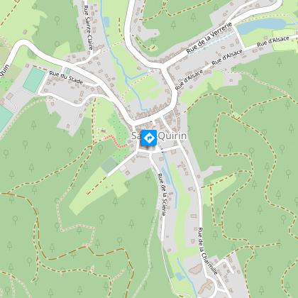
THE TRÂ KIEUCHEU DÉ MOTEU TRAIL
Description
Trâ kieucheu dé Moteu or Bulbes is one of three short walks designed for those with little time to spare when visiting Saint-Quirin. It takes 1 hour to complete and is of moderate difficulty, given the terrain. As it is a circular route, it can be walked in either direction. Please note that the description is clockwise.
The start is in the parish priest's garden (behind the main church - rue de l'abbaye).
- Walk 300 m up rue de l'Abbaye towards the cemetery. Turn left for 50 m onto the path perpendicular to the cemetery, climb the 3 steps to the right and follow the path into the undergrowth.
- After 240 m, continue to the left towards milestone no. 485.
- After 50m and a few steps, take the wide track on the left.
- After 300m and a steep climb, the path joins the forest road (RF) to Haute-Chapelle, which you should follow to the right. As you go along, you can admire the ice rock on your left, which can turn into an ice organ in winter.
- After 800m, you are at the junction of the Haute-Chapelle and Stée footpaths. Take the large track on your right.
- After 150m, turn right onto a small track that leads down to the stadium. Follow this for 600m until you reach a tarmac road which you will walk up on the right for 150m.
- When you come to a calvary, take the small concrete staircase with 5 steps and follow the grassy path upwards along a fenced meadow.
- After 230m you will come to the Haute-Chapelle and a panoramic view of the village.
- Head back down towards the village along the wide stone path which, after 400m, leads to the church next to the parish priest's garden. The church houses a Silbermann organ and a chandelier from Saint-Louis-lès-Bitche.
Technical Information
Altimetric profile
Starting point
Points of interest

Data author
