Alert
Alerts
Replanette walking loop
IGN cards


Description
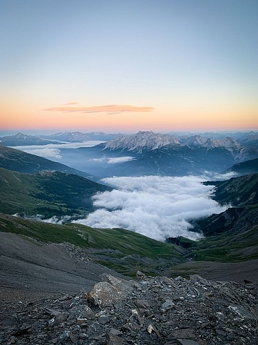
Explore an easily accessible high-altitude plateau and get close to the Thabor massif. Just outside the ski resort of Valfréjus, an exhilarating escape awaits you. Walkers and trailers, the GR5 takes you to the heart of lakes and peaks.
Follow the emblematic GR®5 as it crosses a well-marked high altitude meadow in the midst of the occasional herds. Its regular profile gives you easy access to the narrow valley junction at 2434 m altitude. Now you're immersed in a high-mountain world much appreciated by backpackers. Will you decide to extend your escapade as far as the Thabor refuge?
If you feel like it, why not take a trip to the Sainte-Marguerite lakes? They invite you to take a refreshing break and punctuate your ascent. A string of peaks protects the area. From the Pointe des Sarrasins to the peaks of the Three Wise Men - Balthazar, Melchior and Gaspard - via the Thabor, birds of prey have made this their kingdom.
On the way back, complete the itinerary with the Col de la Vallée Étroite at 2438 m altitude. This is one of the oldest traditional crossings between the Maurienne and Italian Piedmont. Can't you just feel the border? Bardonnechia and the Hautes-Alpes department are just a few steps away.
The Replanette balcony now offers an easy-to-cross ridge. The whistling of marmots echoes and accompanies you all the way to La Losa. When you arrive at the Lavoir, you'll be asking for more!
Technical Information
Altimetric profile
Starting point
Points of interest


Additional information
Open period
From 15/06 to 15/10.
Subject to favorable snow and weather conditions.
Updated by
Communauté de communes Haute Maurienne Vanoise - 01/09/2025
www.cchautemaurienne.com
Report a problem
Environments
Lakeside or by stretch of water
Mountain view
Mountain location
Waterside
Presence of livestock and guard dogs
Contact
Phone : 04 79 05 99 06
Email : info@hautemaurienne.com
Website :
https://www.haute-maurienne-vanoise.com
http://www.cchautemaurienne.com/jy-vais-en
Type of land
Rock
Stone
Ground
Not suitable for strollers
Location complements
To get there by car: Take the RD 216 to Valfréjus, then take the driveway to the washhouse and park in the washhouse parking lot.
Topo guides and map references
Topo guides references :
Map and booklet "Haute Maurienne Vanoise. 115 walks and hikes - 35 trail routes. For all levels" (sold for €10 in Tourist Offices) - Orange itinerary n°60
Map references :
Map IGN 3535OT - Névache Mont Thabor
Reception complements
The duration of hiking trails is calculated using reference paces: 300 m/h ascent, 500 m/h descent and 4 km/h on the flat.
As hazards may occur at any time on the routes, the GPX tracks provided are not contractual. They are given for information only. Riders use them at their own risk, depending on their level of technological proficiency and their understanding of the terrain.
Guidebook with maps/step-by-step
To guide you in the field, consult the "step-by-step" directional diagram provided in pdf.
Animals
Yes. Pets are not allowed on this tour.
Data author
