Alert

Alerts

To see around
See more
Open
Close
Show
Show
Show
Show
Show
Show
Show
Show
Show
Show
Show

Oups... It would appear that Cirkwi does not have permission to use your location.

Presentation
Description
Map
Points of interest
Ratings and reviews
See around

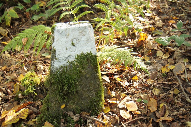
Sur les traces de la frontière hollandaise

Dutch boundary signs in the woods in Erquelinnes
Panoramic view of the old quarries in Erqulinnes
Areas of biological interest in Erquelinnes
Walk in the woods of Solre in Erquelinnes
Hikers in the woods in Erquelinnes
Credit : C.Warzée

Description

Take a breath of fresh air within the forest range of the Solre woods, with a magnificent view of the former quarries. The Solre woods are a range that primarily comprise oak stems, beech trees and hornbeams, not to mention the oldest tree in the forest: an oak that is more than 400 years old. Along this route, old Dutch boundary markers outline the borders between France and the Netherlands in 1819. Located within a forest range on the right-hand bank of the Thure river, areas of biological interest invite relaxation, with ponds and bodies of water in which no fewer than nine species of amphibian breed. 

Technical Information

Walking
Difficulty
Easy
Duration
1h50mn
Dist.
6.9 km
Show more

Altimetric profile

Starting point

12 Rue Trieu Colinot , 6560   Erquelinnes
Lat : 50.27992Lng : 4.13345

Additional information

Designer

The route was designed by Syndicat d'initiative d'Erquelinnes

Code signalétique

n°14

Signalétique (EN)

N1 (Pedestrian) - Green

Data author

99, route de la Plate Taille 6440 Boussu-lez-Walcourt Belgique

Ratings and reviews

To see around
See more
Open
Close
Show
Show
Show
Show
Show
Show
Show
Show
Show
Show
Show
Caution!
We have no information on the difficulty of this circuit. You may encounter some surprises along the way. Before you go, please feel free to inquire more and take all necessary precautions. Have a good trip! 🌳🥾