To see around
See more
Open
Close
Show
Show
Show
Show
Show
Show
Show
Show
Show
Show
Show

Oups... It would appear that Cirkwi does not have permission to use your location.

Description
Map
Steps
Points of interest
Ratings and reviews
See around

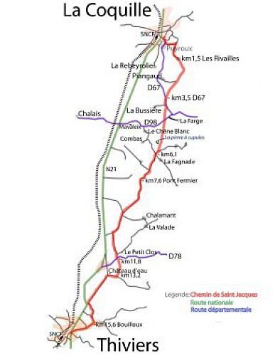
Voie de Vézelay Etape 1 : La Coquille-Thiviers

carte la coquille  thiviers
Credit : cg24

Description

The Vézelay route is one of the great pilgrimage routes used by a thousand pilgrims each year who come from the north of Europe before entering France and reaching Vézelay, one of the great departures identified for the French routes.
This route enters the Périgord via La Coquille.
From La Coquille to Thiviers, you will notice the "cupule stone", which is the subject of various legends. Make yourself count one if you cross someone of the country
When you arrive in Thiviers, you will admire the Saint Roch cross at the roundabout. At the Tourist Office, the gourmets will visit the museum of foie gras, the others will make a pause on the benches of the pilgrim.

Technical Information

Walking
Difficulty
Hard
Dist.
18 km
Show more

Altimetric profile

Starting point

, 24450 LA COQUILLE
Lat : 45.539991621Lng : 0.977462635

Steps

image du object
1

La Coquille-La Pierre à Cupules

Depuis l'église prendre la rue La Boétie en descendant et au bout tourner à gauche sur la D67 vers St-Paul la roche puis à gauche la route du Moulin de Margot au carrefour prendre à droite montée vers les Rivailles. Continuer le chemin qui tourne ensuite à droite en montant dans les bois au croisement, prendre le chemin à droite sur le plateau tout droit à travers bois et champs. Carrefour de chemins prendre tout droit le chemin herbu continuer tout droit en sous-bois prendre à gauche puis au carrefour de la route de la Bussière aller au milieu sur le chemin de terre entre les champs déboucher sur une route allez en face dans le chemin des cupules où vous pourez admirer la pierre à cupules

- Dordogne -
Consulter
image du object
2

La Pierre à Cupules-Thiviers

Retrouver ensuite la route continuer tout droit au carrefour aller tout droit sur la petite route pour arriver à un pont fermier. Suivre la route pendant environ 3 km. Carrefour à gauche pour rejoindre un nouveau carrefour du Petit clos aller à droite pour couper la route continuer en face dans le chemin pour rejoindre une route goudronnée. Tourner à droite au château d'eau puis carrefour prendre à gauche la route Napoléon rectiligne en direction de Thiviers avant d'arriver à la N21 tourner dans une petite route à gauche et au carrefour suivant aller encore à gauche pour rejoindre la D80 au lieu dit Bouilloux au stop aller à droite. Continuer tout droit et poursuivre sur l'avenue Eugène Leroy au rond-point Saint-Roch traverser avec prudence pour prendre à gauche la rue du Général Lamy et la rue Jean Jaurès de Thiviers.

- Dordogne -
Consulter

Additional information

Balisage

Yellow
Balisage jacquaire

Typologie de l'itinéraire

Walking trail

Thèmes

Compostela

Contact

Fixed telephone : +33 5 53 82 85 79
Philippe Debet Service du Tourisme
e-mail : p.debet@dordogne.fr
Web site (URL) : rando.cg24.fr/?page_id=25

Data author

Image Dordogne
proposed by Dordogne
24000 France

Ratings and reviews

To see around
See more
Open
Close
Show
Show
Show
Show
Show
Show
Show
Show
Show
Show
Show
Caution!
We have no information on the difficulty of this circuit. You may encounter some surprises along the way. Before you go, please feel free to inquire more and take all necessary precautions. Have a good trip! 🌳🥾