Alert
Alerts
The Cross of Auzat
Description
This tour oscillates between abandoned vineyards, valleys and hills of Livradois-Forez with splendid views over all the mountains of Auvergne. We walk on the old coal mining lands of Brassac-les-Mines (12th to 19th century).
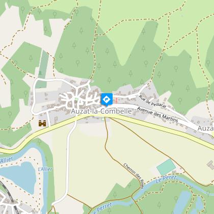
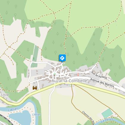
Starting point - From the starting sign, walk along the square in the direction of the Saut du Loup. Turn right into rue de la Poste and then right into rue du Ruisseau. In the square, (church of the 11th-15th centuries, with Piétà) go right up the rue de la Bonne Vierge to the exit of the village.
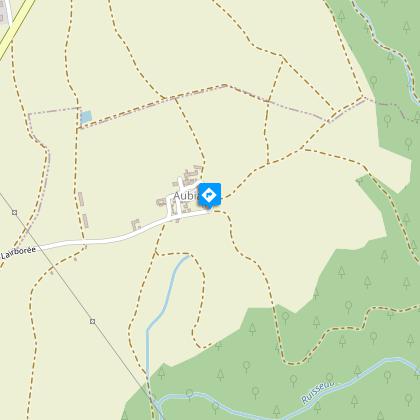
1 - The dirt road climbs on the plateau (view on the hillock and the village of Nonette, the Cézallier, the Sancy massif and the Puys chain). Ignore the small paths on the left and right to reach and cross the D214. A small asphalt road leads up to the entrance to Aubiat. Continue straight ahead along the Esteil road until you leave the village.
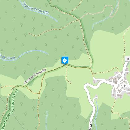
2 - The path then rises, on the right, on the hillside (view on the valley of the Allier, La Combelle and the Lembron). We join a path in a clearing. Go up to the right, ignore the small paths on the left and right to lead to a flat area (view on the first foothills of the Livradois). At the intersection, at the entrance to Esteil, continue straight ahead, turn left and then right. Walk past the church (former priory and remains of the cloister), continue under a porch and join the road to Jumeaux. Leave this road before leaving the village by a street on the right leading back to the intersection at the entrance of the village. Continue on the left until you reach the Croix d'Auzat.
3 - Make a 5-minute round trip to a small building at the top of the hill (view of the hills of the County, the Puys mountain range, the Issoire basin, the Sancy massif and the Cantal mountains). From the Croix d'Auzat, go down the path and at the next fork, turn right and then turn left. Go down ignoring the small paths to the left and right until you reach the D34. Follow it on the right for a few meters, then take the path on the left which passes next to the stadium of Auzat-sur-Allier to reach the starting point.
Technical Information
Altimetric profile
Starting point
Steps
Additional information
Tips
- Numerous viewpoints and panoramas: over the hillock and village of Nonette, and in the distance over the Cézalier, the Sancy massif, the Puys chain, the Allier valley, La Combelle, Lembron and the foothills of the Livradois.
- From the Auzat cross, views of the Buttes de la Comté, the Chaîne des Puys, the Bassin d'Issoire, the Allier valley, the Sancy massif, the Monts du Cantal and the Margeride.
- Auzat church (11th-15th centuries) with Pietà.
- Small oratory with statue of the Virgin included in a private house.
- Auzat-sur-Allier: old winegrowing village, former coal port.
Updated by
Conseil départemental du Puy-de-Dôme - 03/06/2026
www.puydedome-tourisme.com/
Report a problem
Environments
In the country
Forest location
Presence of livestock and guard dogs
Distinctions
Listed PDIPR
Open period
From 01/01 to 31/12 daily.
Subject to favorable weather.
Location complements
From A75 exit n°17 towards Jumeaux / Auzat-la-Combelle. Turn left onto D214 to Auzat-sur Allier, crossing the Allier at Saut du Loup.
Contact
Phone : 04 73 89 15 90
Email : tourisme@capissoire.fr
Website : http://www.issoire-tourisme.com
Reception complements
For your own safety, always take a bottle of water, a hat, warm clothing and footwear suitable for walking.
Depending on weather conditions, certain itineraries are not recommended in bad weather (fog) or are not practicable, or even forbidden, during the winter season.
Some sites are fragile, so stay on the marked trails. Avoid picking wild flowers and disturbing wildlife. Pick up your garbage.
Animals are not allowed on some routes.
Guidebook with maps/step-by-step
1/ From the start sign, walk along the square towards Saut du Loup. Turn right into rue de la Poste, then right into rue du Ruisseau. In the square (11th-15th-century church with Piétà), turn right up rue de la Bonne Vierge to the village exit.
2/ The dirt track climbs up to the plateau (view of the hillock and village of Nonette, the Cézallier, the Sancy massif and the Chaîne des Puys). Ignore the small paths to the left and right to reach and cross the D214. A small asphalt road leads up to the entrance to Aubiat. Continue straight ahead on the Route d'Esteil until you reach the village exit.
3/ The path then rises up the hillside on the right (view of the Allier valley, La Combelle and Lembron). You reach a path in a clearing. Climb to the right, ignoring the small paths to the left and right, to reach a flat area (view of the foothills of the Livradois). At the intersection, at the entrance to Esteil, go straight ahead, turn left then right. Pass the church (former priory and remains of the cloister), continue under a porch and join the route de Jumeaux. Leave this road before leaving the village, taking a right-hand turn that leads back to the intersection at the entrance to the village. Continue left to the Croix d'Auzat.
4/ Walk back and forth for 5 minutes to a small building at the top of the hill (view of the Comté hills, the Puys chain, the Issoire basin, the Sancy massif and the Cantal mountains). From the Croix d'Auzat, go down the path and at the next fork, turn right, then left. Descend, ignoring the small paths to the left and right, until you reach the D34. Follow it to the right for a few metres, then take the path on the left that runs alongside the Auzat-sur-Allier stadium to get back to the starting point.
Proposed and managed by the Conseil départemental du Puy-de-Dôme - PDIPR.
Animals
Yes. Dogs must be kept on a leash due to the presence of herds.
Data author
