Alert
Alerts
From colliers to boatmen
Description
This itinerary located in the Val d'Allier highlights the traces of the daily life of the miners who extracted coal from the mineshafts to store it on large flat-bottomed boats sailing on the Allier and then on the Loire.
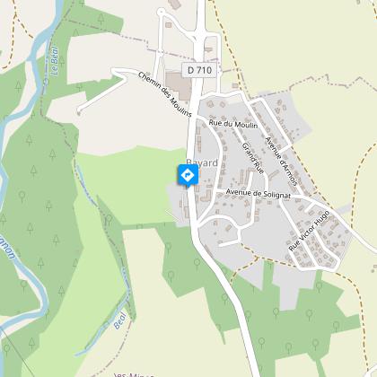
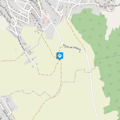
Starting point - From the car park, cross the D710, go around the Communauté de Communes building on the right, go under the porch, cross the road of La Combelle and take the rue de Solignat opposite until you reach the avenue des Gueules-Noires. Take the dirt road on the left for 50 m, continue on the right and join the asphalt road, follow it on the right for 60 m and then turn left to go up on the plateau (view on the Nonette hill, the headframes and the Sancy) until a fork (leave the circuit Des Pas des Mineurs).
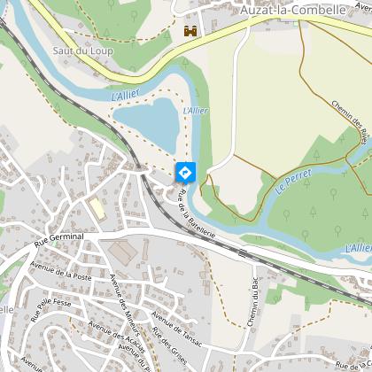
1 - At the cabin, go down on the left on La Combelle. At the houses, turn right until you reach the entrance of the old mine (Le puits des Graves, hot room, memorial), go down and turn left. After 80 m on the left, go up avenue du Puy-de-Dôme, turn left avenue d'Usson towards the orientation table, cross the plateau and join the road. Take the stairs on the right to the street below, turn left then 200 m (Galerie d'apprentissage des Mines. École Papillon) turn right onto rue Pelle-Fesse, leave the street on the left. At the stop sign, turn right, then turn left immediately towards the chapel, take the alley on the left, then right on avenue de la Poste. At the stop sign, cross over and leave rue de Petit-Puits on the right, take the 1st street on the right and in the housing estate turn right into rue des Grises then left into rue Descente des Grises. At the stop sign, turn right onto Avenue de Tansac and then left onto Rue du Bac towards Brassac. Continue to the left, pass under the railway and take rue de La Batellerie towards l'Allier (old footbridge).
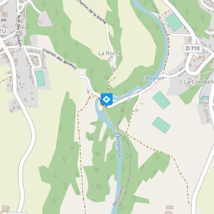
2 - Go up on the left, turn off towards the houses, continue on the right ignoring the rue du 19 Mars 1962, turn left on rue de la Roche and follow the rue des Écoles. At the stop sign, turn right onto rue Germinal until you reach the crossroads (bus shelter) towards Bayard. Before the esplanade, go down the stairs on the right to the street below. Turn left and after the bend follow rue Marcel-Renesio until you reach the old pumping station, on the banks of the Allagnon river.
3 - Take the track to the left of the road, at the sports field, turn right, join the road and follow the Allagnon. Before the footbridge follow the path on the left along the river, continue on the wider path and join the D710, cross it. Turn right for 80 m then left and right on the road to the houses. Follow the rue des Chambettes, then the avenue d'Armois, take the first right, then the 2nd street on the left route de la Combelle. Go under the porch and get back to the starting point.
Technical Information
Altimetric profile
Starting point
Steps
Additional information
Distinctions
Listed PDIPR
Tips
- View of the Butte de Nonette, the headframes and the Sancy.
- Graves shaft, hot chamber, memorial.
- Old footbridge.
- River Allagnon.
Updated by
Conseil départemental du Puy-de-Dôme - 03/06/2026
www.puydedome-tourisme.com/
Report a problem
Environments
Presence of livestock and guard dogs
Open period
From 01/01 to 31/12 daily.
Subject to favorable weather.
Contact
Phone : 04 73 89 15 90
Email : tourisme@capissoire.fr
Website : http://www.issoire-tourisme.com
Location complements
On the A75, exit 18 Brassac, 2nd traffic circle D76 towards the Musée de la Mine, then D710 to the Bayard chevalement. The parking lot is next to the museum.
Topo guides and map references
Topo guides references :
2015 - Randos au fil de l'eau - Discovering the Puy-de-Dôme - Conseil départemental du Puy-de-Dôme
Reception complements
For your own safety, always take a bottle of water, a hat, warm clothing and footwear suitable for walking.
Depending on weather conditions, certain itineraries are not recommended in bad weather (fog) or are not practicable, or even forbidden, during the winter season.
Some sites are fragile, so stay on the marked trails. Avoid picking wild flowers and disturbing wildlife. Pick up your garbage.
Animals are not allowed on some routes.
Guidebook with maps/step-by-step
1/ From the parking lot, cross the D710, turn right around the Communauté de Communes building, pass under the porch, cross the route de La Combelle and take the rue de Solignat opposite to the avenue des Gueules-Noires. Take the dirt track on the left for 50 m, continue to the right and join the tarmac road, follow it to the right for 60 m then turn left to climb onto the plateau (view of the Butte de Nonette, the chevalements and the Sancy) to a fork in the road (leaving the Des Pas des Mineurs circuit).
2/ At the hut, turn left down to La Combelle. At the houses, fork right to the entrance to the old mine (Le puits des Graves, hot chamber, memorial), go down and then turn left. After 80 m, turn left up Avenue du Puy-de-Dôme, left on Avenue d'Usson towards the viewpoint indicator, cross the plateau and join the road. Take the stairs on the right to the street below, turn left and after 200 m (Galerie d'apprentissage des Mines. École Papillon) turn right into rue Pelle-Fesse, leaving the street on the left. At the stop sign, turn right, then immediately left towards the chapel, then left into the lane, then right into avenue de la Poste. At the stop sign, cross to the right into rue de Petit-Puits, take the 1st street on the right and, in the housing estate, turn right into rue des Grises, then left into rue Descente des- Grises. At the stop sign, turn right into avenue de Tansac, then left into rue du Bac towards Brassac. Continue left, passing under the railroad and taking rue de La Batellerie towards the Allier (old footbridge).
3/ Climb left, turn towards the houses, continue right, ignoring rue du 19 Mars 1962, fork left into rue de la Roche and follow rue des Écoles. At the stop sign, turn right onto rue Germinal as far as the crossroads (bus shelter) towards Bayard. Before the esplanade, go down the stairs on the right to the street below. Turn left and, after the bend, follow rue Marcel-Renesio to the old pumping station on the banks of the Allagnon.
4/ Take the path to the left of the road, at the sports ground, turn right, rejoin the road and follow the Allagnon. Before the footbridge, take the left-hand path along the river, continue on the wider path and join the D710, cross it. Turn right for 80 m, then left and right to the houses. Follow rue des Chambettes, then avenue d'Armois, take the first right, then the 2nd left onto route de la Combelle. Pass under the porch and return to the starting point.
Proposed and managed by the Conseil départemental du Puy-de-Dôme - PDIPR.
Animals
Yes. Dogs must be kept on a leash due to the presence of herds.
Data author
