Alert
Alerts
The waterfall
Description
Discover the Livradois-Forez region through a hike in a mid-mountain area...
Technical Information
Altimetric profile
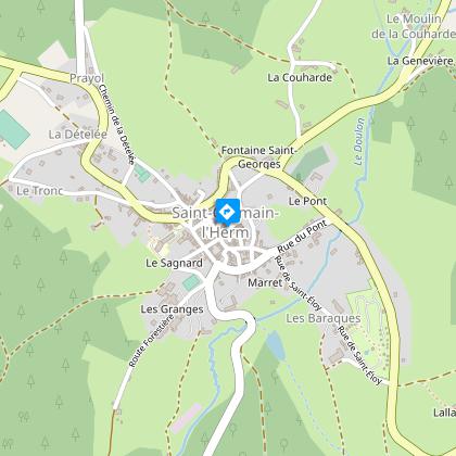
Starting point
Steps
Additional information
Distinctions
Listed PDIPR
Tips
- The St-Germain-l'Herm national forest.
- View of the Chaîne des Puys and the Livradois-Forez region.
Updated by
Conseil départemental du Puy-de-Dôme - 02/07/2026
www.puydedome-tourisme.com/
Report a problem
Environments
In the country
Forest location
Presence of livestock and guard dogs
Open period
From 01/01 to 31/12 daily.
Subject to favorable weather.
Contact
Phone : 04 73 72 05 95
Email : contact.saint-germain-lherm@vacances-livradois-forez.fr
Website : https://www.auvergne-livradois-forez.com/
Location complements
From Ambert, take the D906 towards Arlanc. On leaving Ambert, take the D996 towards Saint-Amant-Roche-Savine. After the Col des Fourches pass, take the D39 left towards Saint-Germain-l'Herm.
Topo guides and map references
Topo guides references :
2014 - Randos à croquer - Discovering the Puy-de-Dôme - Conseil départemental du Puy-de-Dôme
Reception complements
For your own safety, always take a bottle of water, a hat, warm clothing and footwear suitable for walking.
Depending on weather conditions, certain itineraries are not recommended in bad weather (fog) or are not practicable, or even forbidden, during the winter season.
Some sites are fragile, so stay on the marked trails. Avoid picking wild flowers and disturbing wildlife. Pick up your garbage.
Animals are not allowed on some routes.
Guidebook with maps/step-by-step
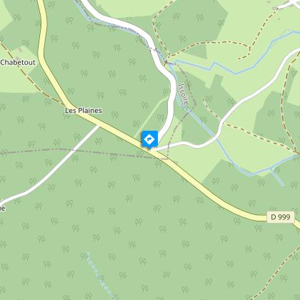
1/ Leaving the church, join the D999 to the north. At the bend in the road, take a wide track and after 400 m, take the left-hand path. Cross the D58, take a forest track opposite to a small road. Turn left to reach the D999.
2/ Follow the D999 for 500 m; at a bend in the road, go straight ahead on a wide track as far as the first house in Chatebout. Turn left onto a track that descends into the undergrowth at La Vigerie. Before the first buildings, turn left onto a wide track leading to Le Sapt.
3/ Cross the Sapt, follow the tarmac road to the transformer and turn left. Climb up to a house and fork left (view of the Chaîne des Puys). At the crossroads, take the path to the right (opposite, pierre des Prades: 200 m A-R). After 400 m, turn left. Follow the D33 and turn left towards Faredonde.
4/ At the ruined house, turn left at the crow's-foot, then right into a dark alley. Follow the forest path to a large clearing. Turn left along a wooded path to the Faredonde stream, then cross it on a well-trodden path to an open valley.
5/ At the waterfall, climb 200 m without taking the forest track, then turn right down a second stream and cross it. At a crow's-foot, take the path that descends slightly to the left, leaving the path that goes straight up and then back up to Cistrières. At the end of Cistrières, turn left down a wide track towards St-Germain and join the church via Rue des Trois Têtes.
Proposed and managed by the Conseil départemental du Puy-de-Dôme - PDIPR.
Animals
Yes. Dogs must be kept on a leash due to the presence of herds.
Data author
