Alert
Alerts
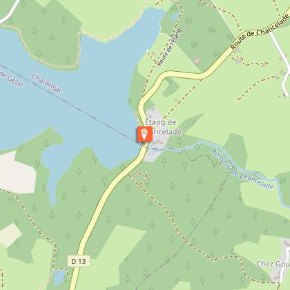
Chancelade pond
Description
The vastness of this pond inspires calm and reverie. An observatory makes the area ideal for discovering the flora and fauna, particularly migratory birds. The pond is also a favourite meeting place for pike anglers.
Technical Information
Altimetric profile
Starting point
Additional information
Distinctions
Listed PDIPR
Tips
The 132-hectare Etang Chancelade is the largest pond in the Puy-de-Dôme department. It is fed by several small streams and brooklets. The overflow from the pond gives rise to the Chancelade stream, which is a sub-tributary of the Sioulet (and therefore of the Sioule) via the Chevalet. It has a capacity of around 2,500,000 m3 and a water height of between 5 and 6 metres. It is mainly used by anglers. The pond and its surroundings are part of a wild and preserved site (Z.N.I.E.F.F).
Updated by
Conseil départemental du Puy-de-Dôme - 02/06/2026
www.puydedome-tourisme.com/
Report a problem
Environments
Forest location
Presence of livestock and guard dogs
Open period
All year round daily.
Subject to favorable weather.
Contact
Phone : 04 73 85 80 94
Email : contact@tourisme-combrailles.fr
Website : https://www.combrailles-auvergne-tourisme.fr/
Facebook : https://www.facebook.com/OfficeTourismeCombrailles/
Location complements
On the D13, between Charensat and Montel-de-Gelat. Parking opposite the
"Chancelade Hôtel" at the end of the pond dike.
Topo guides and map references
Topo guides references :
2015 - Randos au fil de l'eau - Discovering the Puy-de-Dôme - Conseil départemental du Puy-de-Dôme
Reception complements
For your own safety, always take a bottle of water, a hat, warm clothing and footwear suitable for walking.
Depending on weather conditions, certain itineraries are not recommended in bad weather (fog) or are not practicable, or even forbidden, during the winter season.
Some sites are fragile, so stay on the marked trails. Avoid picking wild flowers and disturbing wildlife. Pick up your garbage.
Animals are not allowed on some routes.
Guidebook with maps/step-by-step
1/ Go as far as the pond and turn right on the path along the shore. Pass a log cabin on the right, two observation pontoons and a footbridge.
2/ Cross the bridge and continue along the path away from the pond, through a fence, past the wood exit to a T-junction. Turn left to reach the village of Troissagnes. In the hamlet, go down to the left and, at the exit, take the track on the left. After 250 m, take the right-hand path and follow it to a crossroads.
3/ Turn left and continue for 2 km, keeping to the left, until you reach the village of Malganne. Cross the village, keeping to the left; 200 m after leaving the village, take a track rising to the left. Follow this up to a stream, which you follow for a few metres before fording. Continue to a fork (cross). Go downhill to the left, joining a wide track in a bend; take this to the left as far as the D13 road. Turn left to return to the starting point.
Proposed and managed by the Conseil départemental du Puy-de-Dôme - PDIPR.
Animals
Yes. Dogs must be kept on a leash due to the presence of herds.
Data author
