Alert
Alerts
Le creux de l'Oulette
Description
Between the Velay plateaux and the Ance valley, this itinerary leads to the charming waterfall of Le creux de l'Oulette, as well as the basaltic organs of Montpeloux, plunging from their full height into the waters of a lake set in a former quarry.
Technical Information
Altimetric profile
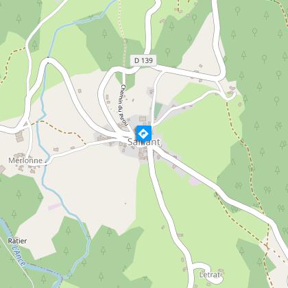
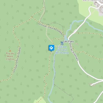
Starting point
Steps
Additional information
Distinctions
Listed PDIPR
Tips
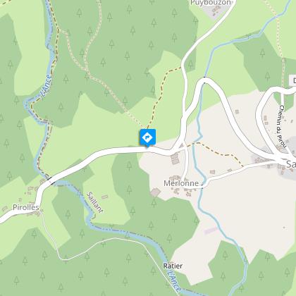
- View of the Ance valley.
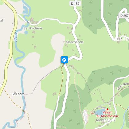
- Montpeloux volcano (basalt cliffs).
- View of the Forez mountains.
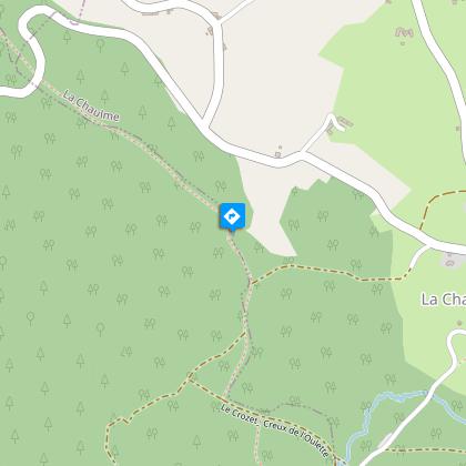
- The creux de l'Oulette waterfall.
- View of Saillant.
Updated by
Conseil départemental du Puy-de-Dôme - 02/06/2026
www.puydedome-tourisme.com/
Report a problem
Environments
Forest location
Mountain view
Presence of livestock and guard dogs
Open period
From 01/01 to 31/12 daily.
Subject to favorable weather.
Contact
Phone : 04 73 95 47 06
Email : saint-antheme.tourisme@wanadoo.fr
Website : http://www.vallee-de-lance.com
Topo guides and map references
Topo guides references :
2015 - Randos au fil de l'eau - Discovering the Puy-de-Dôme - Conseil départemental du Puy-de-Dôme.
2019 - Volcano hikes - Discovering the Puy-de-Dôme - Conseil départemental du Puy-de-Dôme.
Type of land
Ground
Location complements
From the village of Saint-Anthème, take the D261 towards Viverols. After 5 km, turn left onto the D139 towards Saillant.
Reception complements
For your own safety, always take a bottle of water, a hat, warm clothing and footwear suitable for walking.
Depending on weather conditions, certain itineraries are not recommended in bad weather (fog) or are not practicable, or even forbidden, during the winter season.
Some sites are fragile, so stay on the marked trails. Avoid picking wild flowers and disturbing wildlife. Pick up your garbage.
Animals are not allowed on some routes.
Guidebook with maps/step-by-step
1/ From Saillant town hall, take the D256 towards Églisolles. Turn left downhill, then right. When you come to a house, go round it to the right and join the road on the left.
2/ After approx. 150 m, take the first track on the right and follow it to the Ance river. Follow the river upstream. Continue through the forest to Bostfranchet. Go right up the asphalt road to the D139. Turn left for approx. 300 m, then left at the chalet onto a tarmac road (view over the Ance valley).
3/ Cross the D139 and continue straight ahead on the road. Before the last house, turn right along a path to the Montpeloux volcano. Return to the path and turn left onto the road, passing through the village of Montpeloux. Take the sunken path on the right after the last chalet (view of the Monts du Forez). Cross the D257 and continue uphill through undergrowth.
4/ In the clearing, turn right, then right again at the next fork. Turn left twice to reach another clearing. Continue straight ahead (ignore the "cascade" off-route path). Before the stream, turn right along the fence. Descend into the forest, turn left at the intersection. At the next junction, turn left for a short round trip to the waterfall. Continue along the right-hand side of the circuit (you can return to the "Creux de l'Oulette" sign off the circuit).
5/ Continue along this rocky path to a large clearing. Turn right onto the carriage road. Cross Le Mont and keep right on the D256. After approx. 200 m, at the bend in the road, take the path on the right (view of Saillant). Cross the road and go down to the Fangody cross. Turn right onto the path, cross the road and climb to Bichelonne. At the hamlet, take the road immediately to the left. Reach Saillant below.
Proposed and managed by the Conseil départemental du Puy-de-Dôme - PDIPR.
Animals
Yes. Dogs must be kept on a leash due to the presence of herds.
Data author
