Alert
Alerts
Lake Sainte Marguerite


Description
Lake Sainte-Marguerite is well worth the effort, offering a peaceful setting ideal for a picnic or a refreshing break. It ‘s a pleasant destination to head for with children.
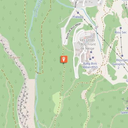
Follow the forest track that starts at the end of the Pra Paisset car park at the bend. After a few hundred meters, continue straight past the Gautier sheepfold. Keep going straight at the intersection with the Via Ferrata sign, 1.8 km from the starting point.
Then turn left at Pré Lapierre on wide, flat terrain. The path then rises on a steep slope. Veer right 250m higher. Continue straight on a wide path through the larches at the next intersection. Turn left at the Rocher Long sign, then follow a rocky steep path. It disappears when entering an alpine meadow after an ascent of a few hundred meters. It is extended by a small path that crosses the high-altitude meadows near the lake cabins. Then cross the stream and continue on a small path in the pastures. Keep climbing, then turn right at the intersection. Continue as far as the lake.
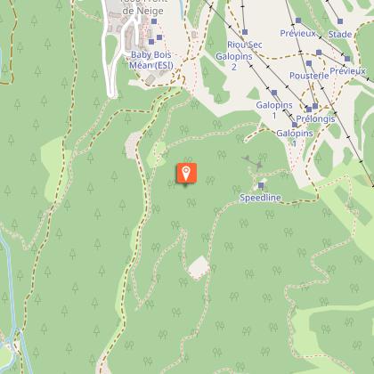
Once you reach the lake, you can walk around it. Then retrace your steps to the previous intersection, take the wooden bridge over the river, continue through the pastures, cross a stream, and follow the path that ascends slightly (the stream is likely to disappear in summer). The route becomes more wooded between clearings and undergrowth, then enters a larch forest. Keep straight when crossing the ruins of old cabins. Turn right and follow the sign indicating the return to the resort at the next intersection. At the next intersection in a clearing, follow the direction “Station par le chalet des Fontaines “ "resort via the Fontaines chalet." Continue straight at the next intersection after a descent.
Once you reach the skiing area, take the wide path that passes under the chairlift. Then follow a small path that goes behind the brasserie restaurant and in front of the Pousterle chairlift, then join the gravel access road and follow it to Les Orres 1800. Then take a right towards Champ Lacas and reach the centre of the resort. Pass under the tunnel towards the shops and join the parking lot on the other side. Take the Bois Méans road at the bend at the exit to the car park. Descend to the hairpin bend below and take a path to the left 20m further on, crossing the balustrade. The path drops down to the Pra Paisset car park.
Technical Information
Altimetric profile
Starting point
Points of interest


Additional information
Advised parking
Pra Paisset car park, les Orres 1800
Public transport
Public transport : ccserreponcon.com
Access
Follow the N94 from Gap or Briançon, then the D40 towards Les Orres at Embrun.
Ambiance
The first part of this hike takes place in the shade of some ancient larch trees, after which the landscape opens up and leads to summer pastures, sometimes described as "cow mountains" by the most experienced mountaineers. The lake, which is hidden from view until the final effort, then appears beneath the peaks reflected in its crystal-clear waters. No need to climb any higher to appreciate the freshness of the setting!
Arrival
Pré Claux Les Orres
Departure
Pré Claux, Les Orres
Data author
